Understory terrain inversion method, device, equipment and medium

A terrain and inversion technology, applied in measurement devices, reflection/re-radiation of radio waves, instruments, etc., can solve problems such as limited practicability and limited acquisition, and achieve deep integration, intuitive principle, and high-precision forest terrain. The effect of inversion

Active Publication Date: 2022-06-24
CENT SOUTH UNIV
View PDF5 Cites 0 Cited by
  • Summary
  • Abstract
  • Description
  • Claims
  • Application Information

AI Technical Summary

Problems solved by technology

Among them, the first type of method usually needs to rely on a large amount of external auxiliary data (such as: temperature data, precipitation data, low-resolution vegetation height data) for modeling, and in order to obtain high-precision forest terrain results, it usually requires research Certain prior information of the region, and the accuracy of the auxiliary data and the selection of the model further limit the practicability of this method; compared with the first method, the second method requires multi-polarization data to separate the surface scattering information, Due to the lack of spaceborne SAR systems that can obtain multi-polarization data, the current method can only conduct related experiments through airborne SAR data, which limits the acquisition of large-scale forest terrain

Method used


Image

  • Understory terrain inversion method, device, equipment and medium
  • Understory terrain inversion method, device, equipment and medium
  • Understory terrain inversion method, device, equipment and medium

Examples


Embodiment Construction

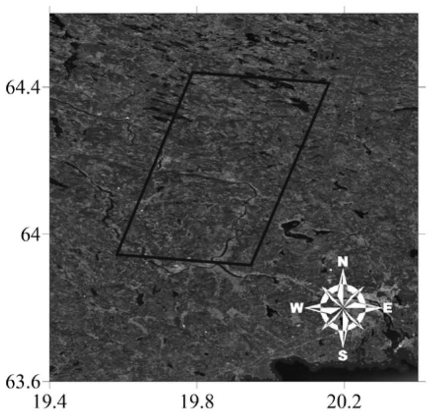
[0062] In order to better illustrate the method and steps of the present invention, the present invention is further described in detail by using the double-station TanDEM-X radar data located in the BioSAR2008 test area in northern Sweden. It should be understood that the specific implementations described herein are only used to explain the present invention, but not to limit the present invention.

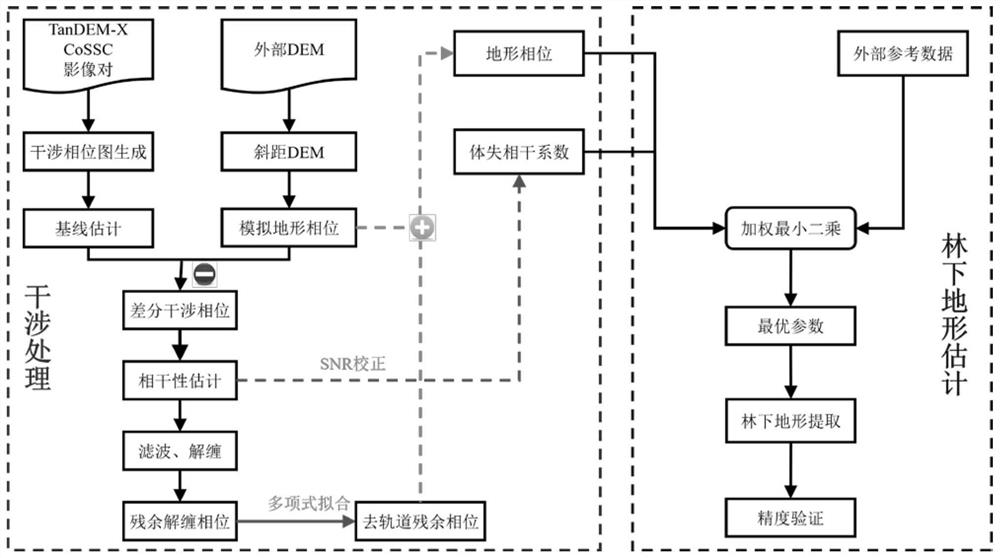
[0063] This embodiment provides an understory terrain inversion method based on dual-station TanDEM-X data, refer to figure 1 shown, including the following steps:

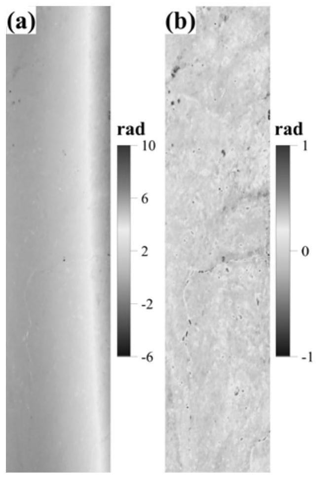
[0064] Step 1: According to the selected coordinate range of the understory topography inversion research area, obtain the dual-station TanDEM-X data corresponding to the German Aerospace Center, and compare the acquired dual-station TanDEM-X data (DLR has passed the ITP data processing software to the data. Certain radiation correction and fine registration are performed) to perform interference processing to obta...


PUM


Abstract

The invention discloses an understory terrain inversion method, device, equipment and medium. The method is as follows: acquiring dual-station TanDEM‑X data in an understory terrain inversion area and performing interference processing to obtain an interference phase and a volume decoherence coefficient; Remove the flat ground, simulated terrain, noise, orbit error and other phases from the interferometric phase to obtain the residual terrain phase; use the residual terrain phase and simulated terrain phase to reconstruct the high-precision InSAR terrain phase; build a forest inversion model, and combine ICESat-2 ground altimetry Point adjustment calculation is performed to solve the unknown parameters in the model; using the volume decoherence coefficient and high-precision InSAR terrain phase information, the understory terrain data of the entire inversion area is calculated according to the understory inversion model. The invention is a robust and feasible method for estimating understory topography, which can be widely used in measuring the height of understory topography in a large range using TanDEM‑X data.

Description

technical field [0001] The invention relates to the field of geodetic surveying based on Synthetic Aperture Radar Interferometry (InSAR), in particular to a method, device, equipment and medium for understory terrain inversion based on dual-station TanDEM-X data. Background technique [0002] Digital elevation model (DEM) is an indispensable basic drawing for national economic construction, social development and national security. In particular, high-precision terrain height information under the cover layer (such as: understory terrain) is of great significance to the fields of natural resource survey, infrastructure construction, national economic development, and national defense security. At present, in order to obtain high-precision terrain height information, synthetic aperture radar (InSAR), LiDAR technology and optical remote sensing technology are commonly used technical means. Among them, InSAR technology has the advantages of all-weather, all-day, short observat...

Claims


Application Information

Patent Timeline
Patent Type & Authority Patents(China)
IPC IPC(8): G01S13/90G01S13/88
CPCG01S13/90G01S13/885
Inventor 朱建军刘志卫付海强王会强赵蓉欧蔓
Owner CENT SOUTH UNIV
Why Eureka
Try Eureka