
Forest grassland fire behavior discrimination method based on remote sensing image and vegetation type graph

A discriminant method and type map technology, which is applied in the field of forest and grassland fire discrimination based on remote sensing images and vegetation type maps, can solve problems such as smoke area interference, unfocused fire scene burning situation, and subjective factors that are greatly affected, and achieve accurate data supported effect

Active Publication Date: 2021-01-05
RES INST OF FOREST RESOURCE INFORMATION TECHN CHINESE ACADEMY OF FORESTRY
View PDF2 Cites 5 Cited by
  • Summary
  • Abstract
  • Description
  • Claims
  • Application Information

AI Technical Summary

Problems solved by technology

However, relying too much on people's subjective judgment not only has the problem of being greatly affected by subjective factors, but also cannot directly obtain the flame height of the fire scene due to tree canopy occlusion, smoke area interference, etc., making it difficult to judge the size of the fire scene
At present, in the daily business monitoring of forest and grassland fires by satellite remote sensing, although the data acquisition is more objective, using the satellite remote sensing data with low and medium spatial resolution (about 1000m) with thermal radiation detection capabilities, most of the burning areas are only shown in satellite images. is the ignition point, and most of them are a mixture of burning areas and non-burning areas; in the daily fire monitoring results of forest and grassland fires, information such as the spatial position (longitude, latitude), brightness temperature, and radiant energy of each ignition point pixel is provided, while Not paying attention to the burning situation of the fire scene (such as radiation intensity, fire line intensity, flame height, etc.)

Method used


Image

  • Forest grassland fire behavior discrimination method based on remote sensing image and vegetation type graph
  • Forest grassland fire behavior discrimination method based on remote sensing image and vegetation type graph
  • Forest grassland fire behavior discrimination method based on remote sensing image and vegetation type graph

Examples


Embodiment Construction

[0033] The technical problems, technical solutions and advantages of the present invention will be explained in detail below by referring to exemplary embodiments and in conjunction with the accompanying drawings. The exemplary embodiments described below are only for explaining the present invention, but not construed as limiting the present invention. Those skilled in the art can understand that, unless otherwise defined, all terms (including technical and scientific terms) used herein have the same meaning as commonly understood by one of ordinary skill in the art to which this invention belongs. It should also be understood that terms such as those defined in commonly used dictionaries should be understood to have meanings consistent with their meaning in the context of the prior art and will not be used in an idealized or overly formal sense unless defined herein to explain.

[0034] Aiming at the accurate judgment of forest and grassland fires, the present invention pro...


PUM


Abstract

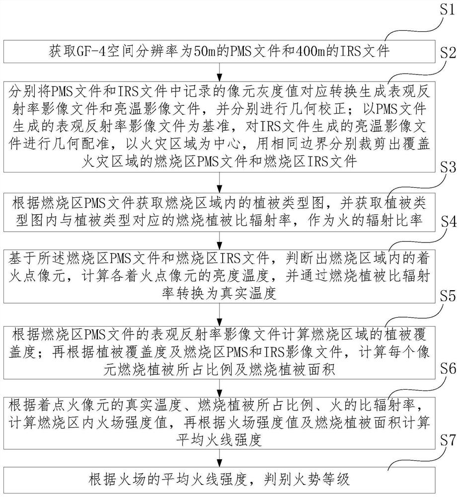
The invention provides a forest grassland fire behavior discrimination method based on a remote sensing image and a vegetation type graph. The method is used for solving the problem that the combustion situation of a fire scene is not quantitatively evaluated in the prior art. According to the forest grassland fire behavior discrimination method based on the remote sensing image and the vegetationtype graph, GF-4 PMI data are utilized, a visible light near-infrared image and a medium wave infrared image are combined and then combined with the vegetation type graph, specific emissivity corresponding to the vegetation type is obtained to serve as specific emissivity of fire, the proportion of the burning vegetation, the area of the burning vegetation and the temperature of the fire are quantitatively calculated, the radiation intensity, the live wire intensity, the flame height and other parameters representing the fire behavior of the forest grassland fire are further calculated, and the fire behavior grade is judged based on the quantitative parameters. Quantitative, reliable and accurate data support of fire scene radiation energy is provided for fire fighting decision making offorest grassland fire disasters.

Description

technical field [0001] The invention belongs to the field of forest and grassland fire monitoring, in particular to a method for discriminating forest and grassland fire intensity based on remote sensing images and vegetation type maps. Background technique [0002] The fire intensity of forest grassland fire refers to the fire intensity level reflected by quantitative indicators such as radiation intensity, fire line intensity, and flame height of the burning area of ​​the fire scene during the occurrence of forest grassland fire, so that fire extinguishing plans can be formulated according to different fire intensity levels. [0003] In the existing technology, after a forest and grassland fire occurs, the flame height of the fire scene is usually obtained by means of ground observation, manned aircraft reconnaissance or unmanned aerial vehicle inspection, and the observer's manual visual inspection and empirical judgment, and then the fire line intensity is estimated from ...

Claims


Application Information

Patent Timeline
Patent Type & Authority Applications(China)
IPC IPC(8): G06K9/00G06K9/62G01J5/00G01N21/25G01N21/47
CPCG01J5/0018G01N21/25G01N21/4738G01J2005/0077G01N2021/1793G06V20/188G06V10/751
Inventor 覃先林胡心雨刘倩李增元
Owner RES INST OF FOREST RESOURCE INFORMATION TECHN CHINESE ACADEMY OF FORESTRY
Learn More