
Relying-free positioning and navigation method and device and storage medium

A navigation method and navigation map technology, applied in surveying and mapping, navigation, navigation, measuring devices, etc., can solve problems affecting the safety of unmanned driving systems, GPS positioning drift, high demand, etc., to reduce communication bandwidth requirements, improve efficiency, The effect of avoiding waste of resources

Active Publication Date: 2020-12-15
XI AN JIAOTONG UNIV
View PDF13 Cites 7 Cited by
  • Summary
  • Abstract
  • Description
  • Claims
  • Application Information

AI Technical Summary

Problems solved by technology

Most of the current unmanned driving systems rely on the GPS global satellite navigation system to achieve self-positioning. However, in the application scenarios of the unmanned driving system, there are many environments where GPS signals are blocked, such as tree-lined roads, urban high-rise buildings, underground garages and other environments, which will cause GPS Positioning drift or even loss seriously affects the safety of unmanned driving systems. Therefore, there is an urgent need for a non-reliant positioning solution to compensate for the safety hazards caused by the lack of GPS signals, that is, it does not rely on any external signals (GPS, WIFI, cellular mobile data, etc.) ) to provide pose information to realize the self-positioning of the unmanned driving platform in natural scenes
The difficulty in solving this problem lies in the following two main aspects: 1. A large number of prior maps need to be stored to achieve unsupported positioning based on vehicle sensors, so the storage and loading of maps requires extremely high memory and cache memory on the computing platform; 2. To ensure real-time and low-latency positioning results, high-speed parallel operation of the overall algorithm framework is required. However, using traditional CPU / GPU for acceleration will inevitably lead to another serious problem, which is excessive energy consumption.

Method used


Image

  • Relying-free positioning and navigation method and device and storage medium
  • Relying-free positioning and navigation method and device and storage medium
  • Relying-free positioning and navigation method and device and storage medium

Examples


Embodiment Construction

[0036] The present invention will be described in detail below in conjunction with the accompanying drawings.

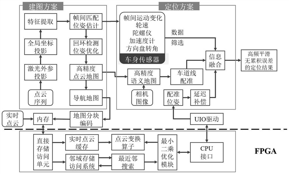
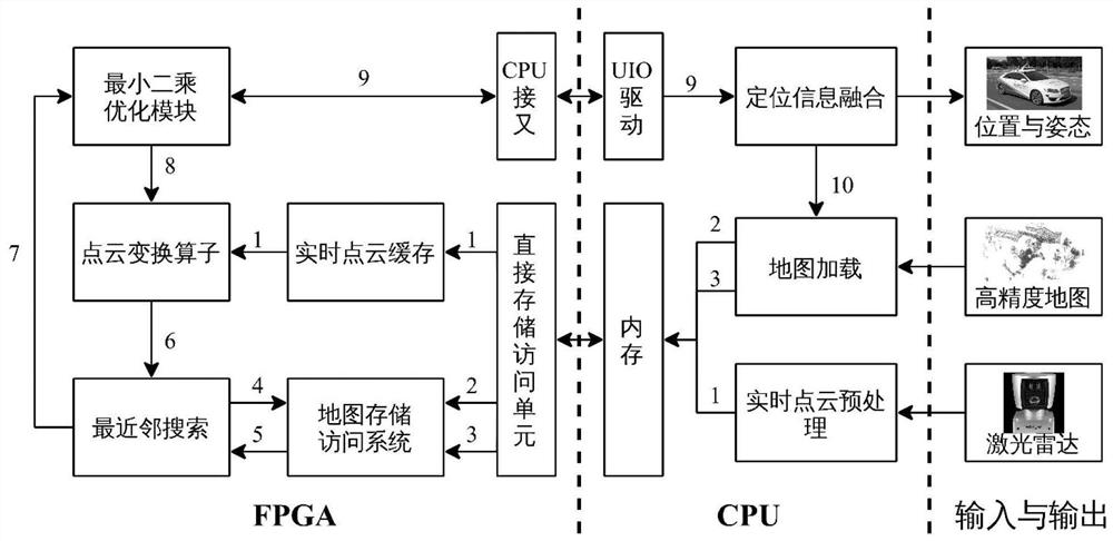
[0037] refer to figure 1 and image 3 , a method for unsupported positioning and navigation, comprising the following steps:

[0038] S100, navigation map construction and map segmentation and coding:

[0039] S101, in terms of map construction, the present invention adopts a synchronous positioning and mapping (SLAM) and inertial navigation system (GPS / DR) collaborative method to construct a high-precision point cloud map, and sequentially through the lidar frame matching and loopback in SLAM The detection and graph optimization algorithm corrects the map of the GPS signal occlusion area to obtain a high-precision point cloud map with greatly improved accuracy and quality and the track information of the unmanned platform in the high-precision point cloud map. For underground Global high-precision map construction can also be achieved in this way for scenarios wi...


PUM


Abstract

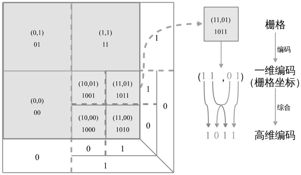
The invention discloses a relying-free positioning and navigation method and device and a storage medium. The method comprises the following steps: cooperatively constructing a high-precision navigation map based on synchronous positioning and mapping and an inertial navigation system; dividing the high-precision navigation map into a plurality of map blocks through a multi-dimensional space dichotomy algorithm, and encoding the map blocks to obtain codes in each map block, the number of point clouds and central position coordinates; performing secondary partitioning and encoding on each blockin the processed high-precision navigation map based on a nearest neighbor search method to obtain grids with higher resolution, and constructing indexes and neighborhood traversal to perform point cloud registration; and performing adaptive positioning on the point cloud registration result by adopting a multi-source fusion algorithm based on extended Kalman filtering to obtain an accurate positioning result. The key problems of map storage and loading, point cloud registration algorithm acceleration and the like in a large-scale scene are solved, and high-precision no-support positioning isrealized; and the drivable area and range of the unmanned driving system are improved.

Description

technical field [0001] The invention belongs to the field of artificial intelligence and unmanned driving, and in particular relates to an unsupported positioning and navigation method, device and storage medium. Background technique [0002] With the continuous development and iteration of artificial intelligence, autonomous mobile agents have higher and higher requirements for key indicators such as positioning accuracy, frequency, and robustness. Most of the current unmanned driving systems rely on the GPS global satellite navigation system to achieve self-positioning. However, in the application scenarios of the unmanned driving system, there are many environments where GPS signals are blocked, such as tree-lined roads, urban high-rise buildings, underground garages and other environments, which will cause GPS Positioning drift or even loss seriously affects the safety of unmanned driving systems. Therefore, there is an urgent need for a non-reliant positioning solution ...

Claims


Application Information

Patent Timeline
Patent Type & Authority Applications(China)
IPC IPC(8): G01C21/32G01C21/34
CPCG01C21/32G01C21/3446
Inventor 郑南宁夏超杨岳东沈艳晴陈仕韬
Owner XI AN JIAOTONG UNIV
Learn More