Mountainous area railway low-altitude survey operation method

A low-altitude, working technology, applied in the field of engineering survey, can solve the problem of not being able to meet the operation requirements of the special working environment in complex mountainous areas, and achieve the effect of improving the level of survey technology, improving survey accuracy, and high efficiency.

Pending Publication Date: 2020-11-10
CHINA RAILWAY FIRST SURVEY & DESIGN INST GRP
View PDF8 Cites 1 Cited by
  • Summary
  • Abstract
  • Description
  • Claims
  • Application Information

AI Technical Summary

Problems solved by technology

[0007] The purpose of the present invention is to provide a low-altitude survey operation method for railways in mountainous areas, which overcomes the problem that the traditional conventional operation methods in the prior art cannot meet the operational requirements of the special working environment in complex mountainous areas, and establishes a method applicable to different ranges, different height differences, different A low-altitude comprehensive survey technology method for survey objects, which can ensure the safe survey operations of UAVs in complex working environments in mountainous areas, meet the technical requirements of different survey environments and objects, and improve the accuracy of low-altitude non-contact surveys in mountainous areas

Method used


Image

  • Mountainous area railway low-altitude survey operation method
  • Mountainous area railway low-altitude survey operation method
  • Mountainous area railway low-altitude survey operation method

Examples


experiment example

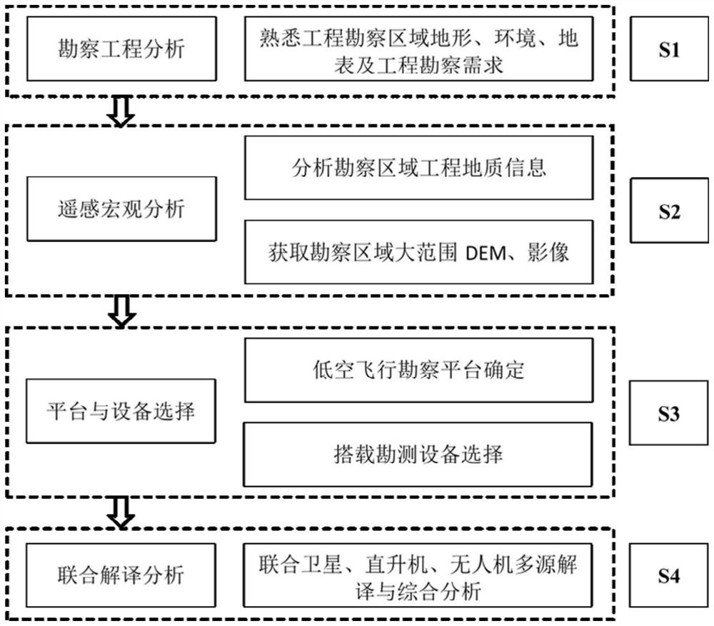
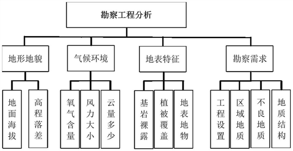
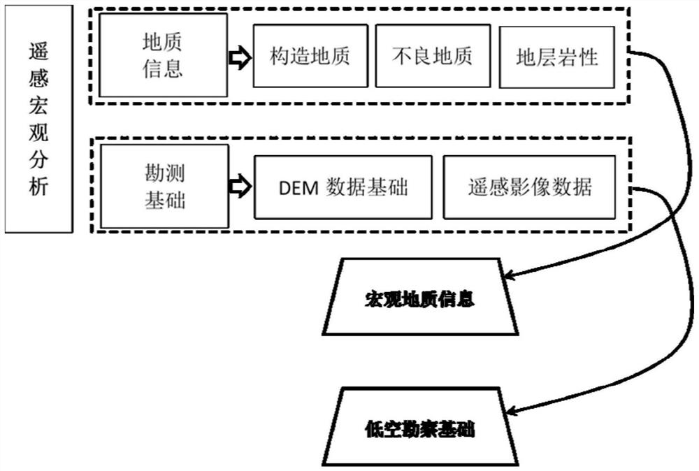
[0042] In the railway survey work in a mountainous area of ​​the Qinghai-Tibet Plateau in the southwest, there are a large number of high and steep slopes connected by bridges and tunnels, with an altitude distribution of 3000-5000m, and a valley elevation drop of more than 1000m. Surveying methods of work. Aiming at different surface characteristic environments such as bedrock exposed mountains and vegetation coverage areas, large-area Gaofen-2 remote sensing images were obtained, combined with UAV and helicopter surveys, equipped with AMC5100 digital tilt aerial camera, RiY-DG4 small digital tilt aerial camera The camera and Riegl VUX-1LR long-range airborne lidar realized comprehensive low-altitude survey of 80 high and steep slopes. The Skyline Terra Explorer basic GIS platform was used to realize multi-source data fusion, and the joint data of different ranges and different precisions was carried out. Interpretation and information extraction have obtained accurate data r...


PUM


Abstract

The invention relates to a mountainous area railway low-altitude survey operation method. The method overcomes the problem that the existing operation method cannot meet the operation requirement of aspecial working environment of a complex mountainous area, can ensure the safe survey operation of an unmanned aerial vehicle in the complex working environment of the mountainous area, and can improve the mountainous area low-altitude non-contact survey precision. The method comprises the following steps of S1, analyzing an operation environment to be subjected to low-altitude survey, and formulating a low-altitude survey operation and geological interpretation technical scheme; S2, carrying out the large-scale and rapid remote sensing interpretation on a survey area to obtain the macroscopic engineering geological information, and obtaining the large-scale DEM and images of the survey area; S3, enabling a low-altitude flight reconnaissance platform to adopt an unmanned aerial vehicle and a helicopter to separately determine and carry the corresponding reconnaissance devices according to the surface features; and S4, carrying out multi-means combined interpretation analysis, adoptinga GIS platform, establishing a three-dimensional geological interpretation sand table, realizing the fusion integration of the remote sensing satellite data and the helicopter and unmanned aerial vehicle survey data, so that the combined interpretation analysis of survey objects is realized.

Description

Technical field: [0001] The invention relates to an engineering survey method, in particular to a low-altitude survey operation method for mountainous railways. Background technique: [0002] With the continuous advancement of national major railway projects and the construction of long-term trunk lines, more and more mountainous railways and high-grade railway projects are gradually increasing, and railway survey and design are faced with a more complex working environment, especially in plateau mountainous railway survey operations. Traditional ground mapping and survey methods are risky and difficult to implement, the efficiency of survey work is low, and survey accuracy needs to be improved. Low-altitude survey methods represented by drones and helicopters can provide flexible and efficient work platforms for mountainous surveys. However, low-altitude surveys in mountainous areas are different from plain environments, and traditional conventional operating methods cannot...

Claims


Application Information

Patent Timeline
IPC IPC(8): G01C7/02G01D21/02G05D1/10B64C39/02
CPCB64C39/02G01C7/02G01D21/02G05D1/101
Inventor 周福军孟祥连杜世回王生仁张文忠黄凯黄勇苗晓岐柏青王栋张坤刘亚林权董杰罗文艺李俊青张晓宇陈兴强冯武超
Owner CHINA RAILWAY FIRST SURVEY & DESIGN INST GRP
Why Eureka
Try Eureka