
Unmanned aerial vehicle area trajectory planning method and device and readable storage medium

A trajectory planning and UAV technology, applied in the field of UAVs, can solve problems such as low operation efficiency and complicated flight trajectory planning methods, and achieve the effects of improved operation efficiency, simple planning and calculation process, and high calculation efficiency

Pending Publication Date: 2020-11-06
SHENZHEN UNIV
View PDF5 Cites 5 Cited by
  • Summary
  • Abstract
  • Description
  • Claims
  • Application Information

AI Technical Summary

Problems solved by technology

[0004] In view of this, the embodiment of the present invention provides a UAV regional trajectory planning method, device and readable storage medium to solve the problems that the existing UAV flight trajectory planning method is relatively complicated and the operation efficiency is low

Method used


Image

  • Unmanned aerial vehicle area trajectory planning method and device and readable storage medium
  • Unmanned aerial vehicle area trajectory planning method and device and readable storage medium
  • Unmanned aerial vehicle area trajectory planning method and device and readable storage medium

Examples


Embodiment Construction

[0046] In order to make the purpose, technical solutions and advantages of the embodiments of the present invention clearer, the technical solutions in the embodiments of the present invention will be clearly and completely described below in conjunction with the drawings in the embodiments of the present invention. Obviously, the described embodiments It is a part of embodiments of the present invention, but not all embodiments. Based on the embodiments of the present invention, all other embodiments obtained by those skilled in the art without creative efforts fall within the protection scope of the present invention.

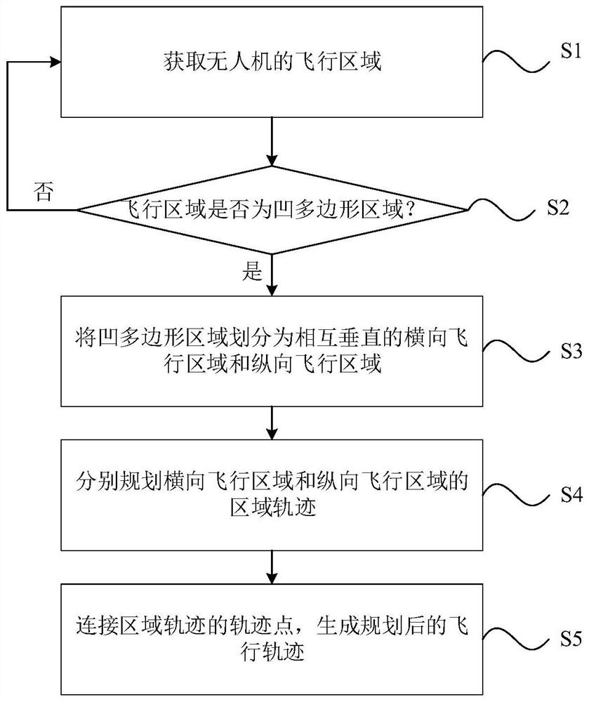
[0047] An embodiment of the present invention provides a method for regional trajectory planning of an unmanned aerial vehicle, such as figure 1 As shown, the method includes:

[0048] Step S1: Obtain the flight area of ​​the UAV; firstly, obtain the flight area of ​​the target of the UAV by means of UAV, satellite, etc., and determine the vertices of the po...


PUM


Abstract

The invention discloses an unmanned aerial vehicle area trajectory planning method and device and a readable storage medium. The method comprises the steps of obtaining a flight area of the unmanned aerial vehicle; judging whether the flight area is a concave polygonal area or not; if the flight area is a concave polygonal area, dividing the concave polygonal area into a transverse flight area anda longitudinal flight area which are perpendicular to each other; respectively planning regional trajectories of the transverse flight area and the longitudinal flight area; and connecting the trajectory points of the regional trajectories to generate a planned flight trajectory. According to the invention, the concavity and convexity of the planning area are judged, and the flight area is divided; therefore, generation of interval areas is avoided, the problem that existing direct round-trip flight does not correctly plan the navigation trajectory of the unmanned aerial vehicle is solved, the trajectories of different flight areas are connected, trajectory planning is completed, the optimal flight trajectory is planned for the concave polygonal area, and when the unmanned aerial vehicleworks normally, the working efficiency is improved, and the working time is saved.

Description

technical field [0001] The present invention relates to the technical field of unmanned aerial vehicles, in particular to a method, device and readable storage medium for planning an unmanned aerial vehicle's regional trajectory. Background technique [0002] With the continuous development of drone technology and airborne remote sensing technology, the application range of drones is becoming wider and wider, mainly in aerial photography, air delivery, and farmland operations. [0003] However, in today's planning methods for UAV polygonal planning areas, by calculating the waypoints covering the entire planning area, the method of connecting the starting points or ending points of all routes according to the principle of the shortest distance, although it can be used for concave polygons The trajectory planning is carried out in the planning area, but in the planning process, it is necessary to judge whether there is an interval area between the two areas, and when connecti...

Claims


Application Information

Patent Timeline
IPC IPC(8): G05D1/10
CPCG05D1/101Y02T10/40
Inventor 李岩山姚若强郭天宇刘瑜王海鹏
Owner SHENZHEN UNIV
Learn More