
A method for searching and positioning karst soil caves

A positioning method and earth cave technology, which is applied in the field of karst soil cave exploration and positioning, can solve the problems of uncertain development location underground concealment, difficulty in exploring and positioning underground karst soil caves, and low accuracy of geophysical prospecting results

Active Publication Date: 2021-09-03
CHONGQING INST OF GEOLOGY & MINERAL RESOURCES
View PDF0 Cites 0 Cited by
  • Summary
  • Abstract
  • Description
  • Claims
  • Application Information

AI Technical Summary

Problems solved by technology

[0003] Due to the typical characteristics of karst soil caves, such as uncertain development location, strong underground concealment, and sudden disaster-causing process, it is difficult to carry out effective monitoring for them at present, and only conventional drilling and geophysical prospecting methods can be used to specifically detect them in advance. After the development location, size, buried depth and other parameters are verified, engineering treatment will be carried out
At present, there are many methods for karst soil cave exploration and positioning, such as geological drilling, geological radar, shallow seismic longitudinal wave reflection method, hole collapse elastic wave CT, high-density electrical method, microgravity, etc.; It is the most direct method to drill a hole, but its cost is high, the detection position is random, and there is a "one-hole view" vision limitation. Often no soil hole is found at the drilled hole position, and as a result, a subsidence occurs next to the drilled position. To achieve large-scale For general survey, it is necessary to reduce the drilling hole spacing to 2-3m / hole, assuming a general survey of 1km 2 area, about 110,000 holes need to be arranged, which is obviously unscientific; for physical detection methods such as geological radar, shallow seismic longitudinal wave reflection method, hole collapse elastic wave CT, high-density electrical method, and microgravity, they have similar The advantage is that it can carry out detection of several kilometers at a time, and the work efficiency is higher than that of geological drilling methods, but there are still many disadvantages. First, it is more restricted by surface vegetation, large surface water bodies and buildings (structures). Second, the linear survey can only be carried out at one time. To realize the planar general survey, it is necessary to arrange a lot of parallel lines, and the distance between the parallel lines generally does not exceed 5m. This is very complicated to implement and the cost is very high. Third, the accuracy of the geophysical survey results is relatively low. Low, the accuracy of the interpretation results depends on the technical level and engineering experience of the interpreters, so the current geophysical prospecting methods are only suitable for fine detection in small areas or rough detection in large areas
[0004] To sum up, it is very difficult to find and locate underground karst caves with large area, low cost, easy operation and high accuracy in terms of the karst soil cave exploration methods commonly used in practical engineering at present.

Method used


Image

  • A method for searching and positioning karst soil caves
  • A method for searching and positioning karst soil caves
  • A method for searching and positioning karst soil caves

Examples


Embodiment 1

[0030] A kind of karst soil hole exploration positioning method comprises the following steps:

[0031] 1. Select the work area to carry out subsidence exploration, conduct statistics on the surface structures, surface water bodies, forest land, grassland, cultivated land and bare land in the work area, and formulate flight routes;

[0032] 2. Use the aircraft to carry non-toxic, pollution-free or low-toxic, low-hazard liquid foaming agent that meets the requirements of environmental protection, and spray it evenly on the surface of the work area. The foaming agent here is pine oil, and the aircraft can be a drone. Or low-altitude aircraft, the spraying density is generally 0.5-2L / m 2 , choose 2L / m here 2 , after spraying, the liquid foaming agent will permeate down to a certain depth along the soil, and at the same time, a part will remain in the pores of the soil. The indoor test is carried out on the soil samples randomly taken from the site to achieve the set foaming conc...

Embodiment 2

[0036] A kind of karst soil hole exploration positioning method comprises the following steps:

[0037] 1. Select the work area to carry out subsidence exploration, make statistics on the surface structures, surface water bodies, forest land, grassland, cultivated land and bare land in the work area, and formulate the search route;

[0038] 2. Use land spraying devices, such as vehicle-mounted or knapsack sprayers, to spray non-toxic, non-polluted or low-toxic, low-hazard solid foaming agents that meet environmental protection requirements. Here, sodium dodecylsulfonate is selected. The solid foaming agent is in powder form; spray evenly on the surface of the work area, and the spraying density is 0.5L / m 2 , after spraying, carry out on-site sampling in different areas such as surface structures, surface water bodies, woodlands, grasslands, cultivated land, and bare land. Indoor test, the indoor test is carried out 2 hours after the soil sample is sprayed with water, so as to...


PUM


Abstract

The present invention relates to the field of geological disasters of soil cave subsidence in karst karst areas, in particular to a method for searching and locating karst soil caves, which comprises the following steps: firstly, selecting the work area where the subsidence exploration needs to be carried out; Spray the foaming agent until the content of the foaming agent in the surface covering soil reaches the design concentration; then observe whether there are bubbles on the surface after the rain, and mark the bubble generation point, which is the possible development position of the karst soil cave Finally, conventional drilling or geophysical prospecting methods are used to detect the bubble point and the adjacent area in detail to determine the detailed characteristics of the soil cave; the karst soil cave exploration and positioning method of the technical solution of the present invention can realize large-area, low-cost, and easy Operational and more accurate detection of the specific development location of underground karst soil caves can significantly reduce the detection target area of ​​karst soil caves, and effectively solve the current bottleneck problem of "where are the soil caves" in the monitoring and prevention of karst collapse.

Description

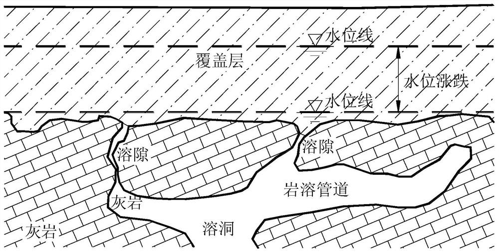
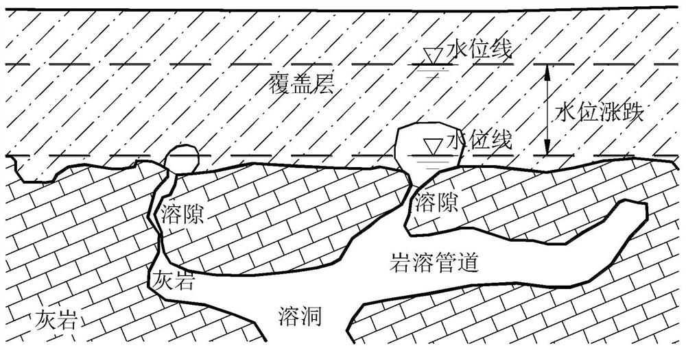
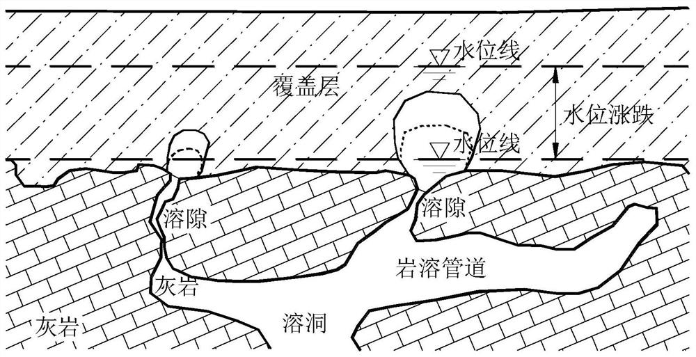
technical field [0001] The invention relates to the field of earth cave subsidence geological disasters in karst karst areas, in particular to a method for searching and positioning karst earth caves. Background technique [0002] Karst soil cave collapse is a common type of geological disaster in karst areas. According to incomplete statistics, there are more than 2,000 karst collapses on average in the country every year, causing direct economic losses of about 50 million yuan, threatening buildings (structures), public ( Railway transportation, cultivated land and other various infrastructures built on karst overburden and the safety of people's life and property. The main reason for karst collapse is that there are soil cavities within a certain depth (generally 3-10m) below the ground, and the inner diameter of the cavities generally ranges from 3-20m. When the soil on the top of the cavity cannot bear the relevant loads, it will collapse. , the direct manifestation of...

Claims


Application Information

Patent Timeline
Patent Type & Authority Patents(China)
IPC IPC(8): G01V9/00G01F23/00E02D1/00
CPCE02D1/00
Inventor 董平廖云平梁丹彭海游马磊余詹陶然
Owner CHONGQING INST OF GEOLOGY & MINERAL RESOURCES
Learn More