
A method and device for vehicle route planning at intersections based on virtual lane lines

A technology of virtual lane lines and intersections, which is applied in the field of vehicle path planning at intersections based on virtual lane lines, can solve problems such as result errors and affect driving experience, and achieve the effects of improving accuracy, high real-time performance, and wide perception range.

Active Publication Date: 2021-09-03
TONGJI UNIV
View PDF7 Cites 0 Cited by
  • Summary
  • Abstract
  • Description
  • Claims
  • Application Information

AI Technical Summary

Problems solved by technology

However, the reference object is blocked, and the distance information is constantly updated during the turning process, which requires a large amount of calculation to calculate the curvature and bending direction of the lane line, resulting in certain errors in the results and affecting the driving experience.

Method used


Image

  • A method and device for vehicle route planning at intersections based on virtual lane lines
  • A method and device for vehicle route planning at intersections based on virtual lane lines
  • A method and device for vehicle route planning at intersections based on virtual lane lines

Examples


Embodiment Construction

[0041] The present invention will be described in detail below in conjunction with the accompanying drawings and specific embodiments. This embodiment is carried out on the premise of the technical solution of the present invention, and detailed implementation and specific operation process are given, but the protection scope of the present invention is not limited to the following embodiments.

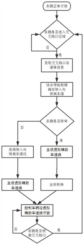
[0042] Such as figure 1 As shown, a vehicle path planning method at an intersection based on virtual lane lines, which improves the safety and reliability of vehicles passing through the intersection, and improves the road conditions at the intersection, has the following steps:

[0043] Step S1: The target vehicle obtains body GPS data and navigation data through the vehicle-mounted GPS sensor, and uploads them to the roadside unit;

[0044] Step S2: The roadside unit (RSU) obtains the lane data at the intersection, and combines it with the received GPS data and navigation data of t...


PUM


Abstract

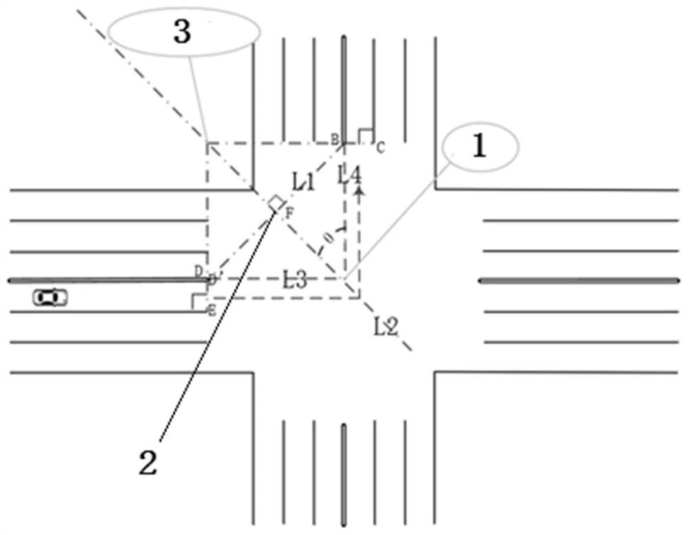
The present invention relates to a vehicle route planning method at an intersection based on virtual lane lines, which comprises the following steps: Step S1: the target vehicle acquires GPS data and navigation data of the vehicle body, and uploads them to the roadside unit; Step S2: the roadside unit acquires the intersection Lane data, combined with vehicle body GPS data and navigation data, to obtain the GPS information of entering and leaving the lane, if entering and leaving the lane parallel to each other, go to step S3, otherwise go to step S4; step S3: connect the driving The lane and the departure lane generate a virtual auxiliary lane line, and the target vehicle drives according to the virtual auxiliary lane line; Step S4: Establish a line model according to the GPS information of the lane port, generate an arc-shaped virtual auxiliary lane line, and convert it to the local plane coordinate system, Get the turning angle, and drive according to the virtual auxiliary lane line and turning angle. Compared with the prior art, the invention has the advantages of improving the safety and reliability of vehicles passing through the intersection, improving the road conditions of the intersection, and the like.

Description

technical field [0001] The invention relates to the technical field of driving assistance, in particular to a method and device for planning vehicle paths at intersections based on virtual lane lines. Background technique [0002] The Internet of Vehicles is an important application of the Internet of Things in the field of intelligent transportation. It integrates vehicles, pedestrians, obstacles, and roadside information into a large network through information interaction between the vehicle terminal, roadside terminal, edge cloud, and central cloud. , to achieve intelligent transportation. At present, the Internet of Vehicles technology is constantly developing. Through the perception of the surrounding environment by roadside and vehicle-side sensors, cars can learn a wealth of surrounding environment information and make decisions, which can greatly reduce the occurrence of traffic accidents. [0003] At present, many Internet of Vehicles applications do not combine r...

Claims


Application Information

Patent Timeline
Patent Type & Authority Patents(China)
IPC IPC(8): G08G1/01G08G1/0967G08G1/16
CPCG08G1/0125G08G1/0137G08G1/096725G08G1/096766G08G1/167
Inventor 王平王新红刘富强任肖阳
Owner TONGJI UNIV
Learn More