A Fast Reconstruction Method of Inertial Navigation Reference During Planetary Landing

A benchmark and planetary technology, applied in navigation through speed/acceleration measurement, integrated navigator, instrument, etc., can solve problems that affect the successful implementation of missions, error in calculating height information, lander crashes, etc., and achieve data validity The effect of judging, improving estimation accuracy, and improving convergence speed

Active Publication Date: 2022-01-04
BEIJING INST OF CONTROL ENG
View PDF0 Cites 0 Cited by
  • Summary
  • Abstract
  • Description
  • Claims
  • Application Information

AI Technical Summary

Problems solved by technology

Once the attitude loses its reference, the height information calculation error will affect the successful implementation of the mission
The 2016 ESA ExoMars Mars mission lander lost its attitude reference due to the saturation of the IMU, resulting in an altitude calculation error that caused a GNC command execution error, which eventually caused the lander to crash

Method used


Image

  • A Fast Reconstruction Method of Inertial Navigation Reference During Planetary Landing
  • A Fast Reconstruction Method of Inertial Navigation Reference During Planetary Landing
  • A Fast Reconstruction Method of Inertial Navigation Reference During Planetary Landing

Examples


Embodiment 1

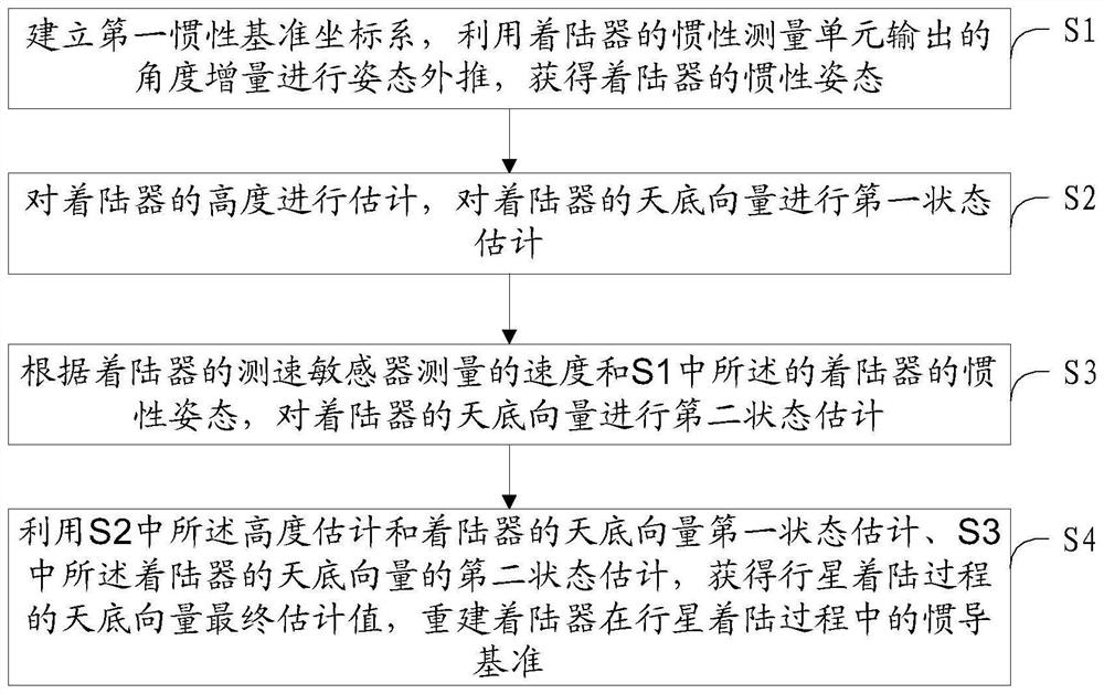
[0046] A fast reconstruction method of inertial navigation reference during planetary landing process, such as figure 1 shown, including the following steps:

[0047] S1. Establish the first inertial reference coordinate system, and use the angle increment output by the inertial measurement unit of the lander to perform attitude extrapolation in the first inertial reference coordinate system to obtain the inertial attitude of the lander.

[0048] The inertial attitude of the lander is:

[0049]

[0050] in

[0051]

[0052] In the formula, q k and q k+1 Respectively represent t k and t k+1 moment pose quaternion, is the quaternion multiplication, Δθ is the angle increment in an attitude update cycle, and δθ is the modulus of Δθ.

[0053] S2. Estimate the height of the lander by using the least squares algorithm, and estimate the first state of the nadir vector of the lander.

[0054] The lander's altitude estimate for:

[0055]

[0056] in

[0057]

[...

Embodiment 2

[0080] The specific calculation process of the rapid reconstruction of the inertial navigation reference during the Mars landing process is as follows:

[0081] 1. Establish the first inertial reference coordinate system, and use the angle increment output by the IMU (ie inertial measurement unit) under the first inertial reference coordinate system to perform attitude extrapolation to obtain the inertial attitude.

[0082]

[0083] where q k and q k+1 Respectively represent t k moment and t k+1 moment pose quaternion, is the attitude quaternion multiplication, q' is the attitude rotation quaternion, given by the following formula:

[0084]

[0085] Among them, Δθ is the angle increment in an attitude update cycle, which is a three-dimensional vector, and δθ is the modulus of Δθ.

[0086] 2. Using the least squares algorithm, the first state estimation and height estimation of the nadir vector of the lander are performed from the distance measurements of multiple b...


PUM


Abstract

A method for quickly rebuilding an inertial reference reference during a planetary landing process, belonging to the technical field of spacecraft autonomous navigation, comprising the following steps: S1, establishing a first inertial reference coordinate system, and performing attitude extrapolation using the angle increment output by the inertial measurement unit of the lander , to obtain the inertial attitude of the lander; S2, estimate the altitude of the lander, and perform the first state estimation on the nadir vector of the lander; S3, according to the speed measured by the speed sensor of the lander and the landing described in S1 The inertial attitude of the lander is used to perform the second state estimation on the nadir vector of the lander; S4, using the height estimation described in S2 and the first state estimation of the nadir vector of the lander, and the nadir vector of the lander described in S3 The second state estimation is to obtain the final estimated value of the nadir vector during the planet landing process, and reconstruct the inertial navigation reference of the lander during the planet landing process. The method of the invention fuses two kinds of nadir vectors, which effectively improves the convergence speed of datum reconstruction.

Description

technical field [0001] The invention relates to a fast reconstruction method of an inertial navigation reference during a planetary landing process, and belongs to the technical field of spacecraft autonomous navigation. Background technique [0002] The Entry, Descent, and Landing (EDL) section of the Mars exploration mission is the last 6 or 7 minutes of the Mars probe’s journey of nearly 700 million kilometers. It is the key stage of the Mars surface exploration mission and the most difficult stage. EDL technology is also one of the key technologies for Mars surface exploration missions. From the time the Mars probe entered the Martian atmosphere at a speed of 20,000 kilometers per hour, it went through a series of stages such as atmospheric deceleration, parachute drag, and power deceleration, and finally in order to ensure a safe and accurate landing on the surface of Mars. Most of the failure cases of Mars exploration are due to the accident of the Mars lander during...

Claims


Application Information

Patent Timeline
Patent Type & Authority Patents(China)
IPC IPC(8): G01C21/24G01C21/16G01C25/00
CPCG01C21/24G01C21/16G01C25/005
Inventor 李茂登黄翔宇郭敏文徐超魏春岭张晓文胡锦昌王晓磊郝策王云鹏张琳
Owner BEIJING INST OF CONTROL ENG
Why Eureka
Try Eureka