Unmanned aerial vehicle navigation and positioning method based on indoor vision Vicon system

A technology of navigation and positioning and UAV, applied in the field of UAV navigation and positioning based on indoor visual vicon system

Active Publication Date: 2020-05-29
西安因诺航空科技有限公司
View PDF19 Cites 1 Cited by
  • Summary
  • Abstract
  • Description
  • Claims
  • Application Information

AI Technical Summary

Problems solved by technology

The Vicon system has high positioning accuracy and fast data update frequency, and can respond in real time to the position and attitude information of the UAV as a motion carrier. The delay of the Vicon system is less than 2.5ms (the maximum refresh rate is 400Hz), but it is limited by the current civilian unmanned Due to the hardware of the data link of the machine, the UAV as a movement carrier cannot accept the data that the data link brushes so fast and the data link is large.

Method used


Image

  • Unmanned aerial vehicle navigation and positioning method based on indoor vision Vicon system
  • Unmanned aerial vehicle navigation and positioning method based on indoor vision Vicon system
  • Unmanned aerial vehicle navigation and positioning method based on indoor vision Vicon system

Examples


Embodiment Construction

[0074] The present invention is further described below in conjunction with accompanying drawing:

[0075] see Figure 1 to Figure 3 , the invention and patent will be described in detail below in conjunction with the accompanying drawings and specific embodiments.

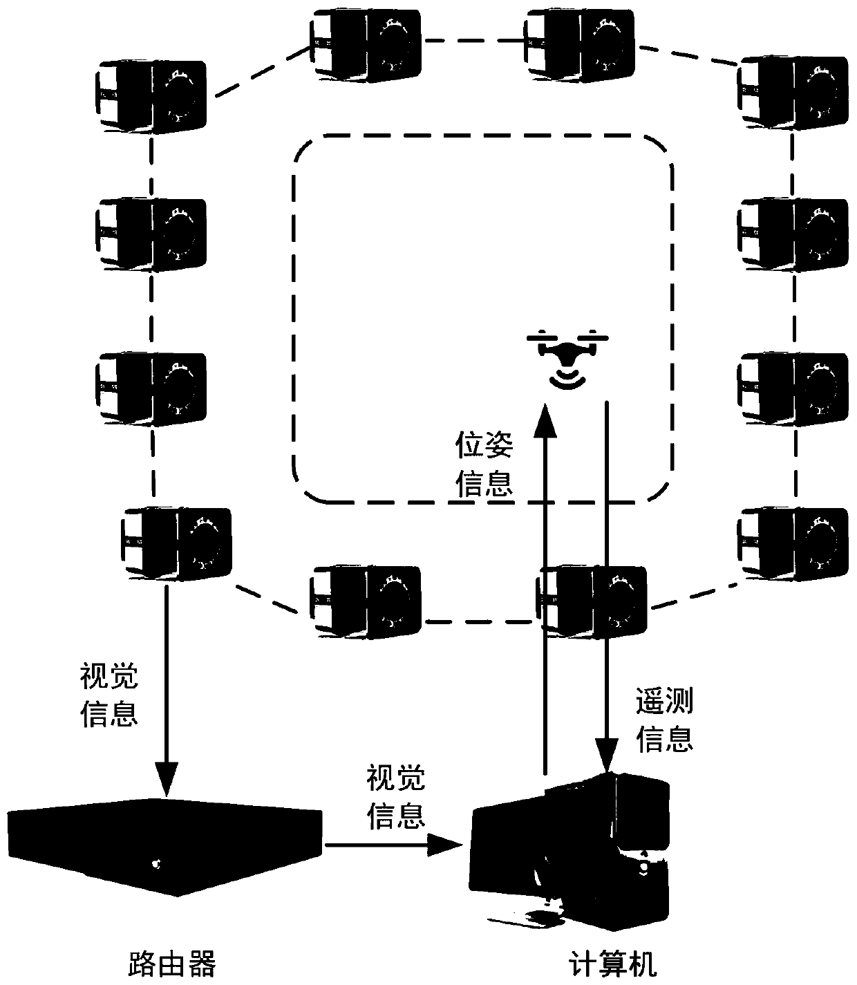
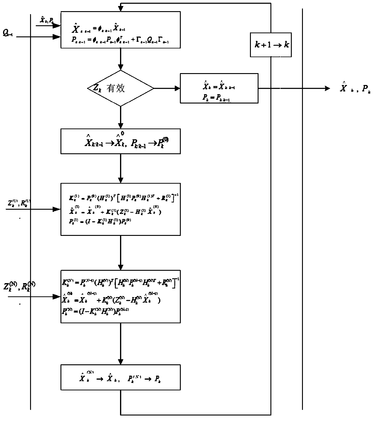
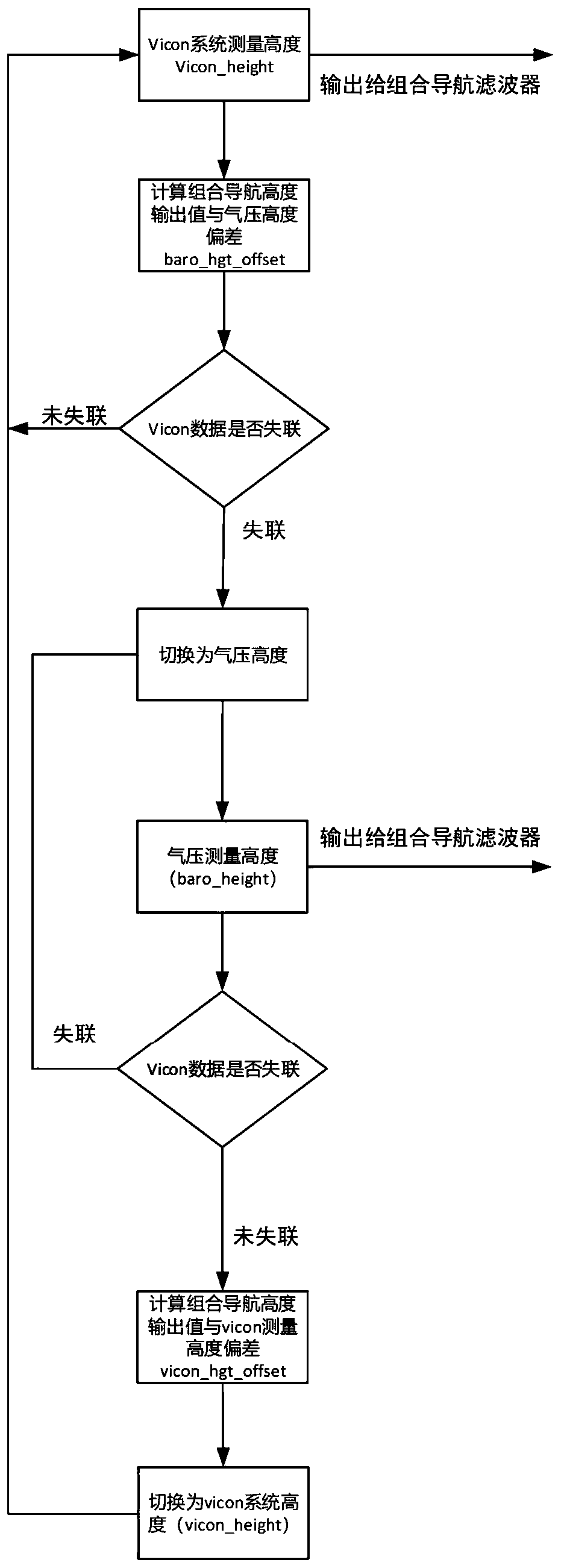
[0076] The structural diagram of this patent is shown in the figure, and the specific implementation process of this patent includes two steps:

[0077] The first step is to start the SDK of the Vicon system, and analyze the position and attitude data of the UAV as the motion carrier obtained by the Vicon system through the wireless data link. The position includes the three-axis position and attitude in the local coordinate system of the Vicon system. Including the drone's roll, pitch and heading information between the X-axis of the Vicon system and the X-axis of the drone's own coordinate system (front lower right);

[0078] In the second step, the UAV receives the attitude and position data uploaded by the V...


PUM


Abstract

The invention relates to an unmanned aerial vehicle navigation and positioning method based on an indoor visual Vicon system. The method comprises steps that 1, an SDK of the Vicon system is started,and position and attitude data, obtained through analysis of the Vicon system, with an unmanned aerial vehicle as a motion carrier are obtained through a wireless data link; and 2, the unmanned aerialvehicle receives the attitude and position data uploaded by the Vicon system through the wireless data link, takes the attitude and position data as the measurement quantity of an integrated navigation algorithm and combines inertial navigation equipment on the unmanned aerial vehicle to perform integrated navigation, and outputs the position, speed and attitude information of the unmanned aerialvehicle in real time. According to the Vicon + INS-based integrated navigation algorithm provided by the invention, high-precision attitude and position precision of the unmanned aerial vehicle in aroom can be realized, the motion speed of the unmanned aerial vehicle under the indoor condition is estimated, the requirement on the data link is reduced, and researchers can focus on the research ofan upper-layer algorithm.

Description

technical field [0001] The invention belongs to the technical field of unmanned aerial vehicles, in particular to a method for navigation and positioning of unmanned aerial vehicles based on an indoor visual vicon system. Background technique [0002] In order to facilitate the research of UAV cluster algorithm, formation coordination algorithm, artificial intelligence algorithm, and intelligent control algorithm, an indoor positioning system laboratory was built, and UAV was used as the controlled object for research. [0003] Since the drone flies indoors and cannot receive GPS signals, an external positioning system is required. Vision-based British Vicon system is a good solution. The Vicon system has high positioning accuracy and fast data update frequency, and can respond in real time to the position and attitude information of the UAV as a motion carrier. The delay of the Vicon system is less than 2.5ms (the maximum refresh rate is 400Hz), but it is limited by the cu...

Claims


Application Information

Patent Timeline
Patent Type & Authority Applications(China)
IPC IPC(8): G01C21/16
CPCG01C21/165
Inventor 李定涌闫永驰陈朋印
Owner 西安因诺航空科技有限公司
Why Eureka
Try Eureka