Cloud base height inversion method and system based on multi-source satellite data

A technology of cloud base height and satellite data, which is applied in the field of atmospheric sounding, can solve problems such as insufficient accuracy, difficulty in obtaining cloud base height, and inability to expand cloud base height, so as to achieve the effect of improving accuracy and expanding coverage

Active Publication Date: 2020-05-22
HUAZHONG UNIV OF SCI & TECH
View PDF4 Cites 2 Cited by
  • Summary
  • Abstract
  • Description
  • Claims
  • Application Information

AI Technical Summary

Problems solved by technology

[0005] Aiming at the defects of the prior art, the object of the present invention is to provide a cloud base height inversion method and system based on multi-source satellite data, aiming to solve the existing method of obtaining cloud base height, which is obtained through active remote sensing or physical model calculation Cloud base height, but cannot effectively extend the cloud base height of limited observation points to other areas, making it difficult to obtain cloud base height or the problem of insufficient accuracy

Method used


Image

  • Cloud base height inversion method and system based on multi-source satellite data
  • Cloud base height inversion method and system based on multi-source satellite data
  • Cloud base height inversion method and system based on multi-source satellite data

Examples


Embodiment

[0124] In the embodiment, the present invention is verified according to the above steps:

[0125] (1) Obtain the historical cloud base height obtained by the Cloudsat satellite and the cloud top temperature, optical thickness and other historical cloud physical characteristics in the Aqua satellite from the satellite database; specifically:

[0126] (1.1) Obtain the 2B-GEOPROF-LIDAR_GRANULE_P1_R05 data product from Cloudsat official website, which can provide the historical cloud base height of each layer, and use it as the output to train the cloud base height inversion model;

[0127] (1.2) Obtain the MYD08_L2 data product of Aqua satellite from MODIS official website, which can provide historical cloud physical quantity characteristics such as cloud top temperature and optical thickness;

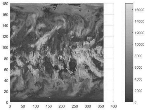
[0128] figure 2 It is the cloud top height distribution map in the world on September 6, 2013 (the unit of cloud top height is meter, the range is: 3m~17070m; scaling factor scale_factor...


PUM


Abstract

The invention discloses a cloud base height inversion method and system based on multi-source satellite data, and belongs to the atmospheric exploration. The method specifically comprises the steps: selecting a cloud layer classification model and a cloud base height inversion model according to the actual longitude and latitude through employing a cosine similarity method; inputting the actual cloud physical characteristics into the cloud layer classification model to obtain actual cloud layer category characteristics; and inputting the actual cloud layer category characteristics and the actual cloud physical characteristics into the cloud base height inversion model to obtain an actual cloud base height; matching the historical cloud base height with the historical cloud physical characteristics; performing data calibration on the initial training set; taking the historical cloud physical characteristics as input, taking the historical cloud class characteristics as output, and training the cloud layer classification model in different regions; and training a cloud base height inversion model in different regions by taking the historical cloud layer category features and the historical cloud physical features as inputs and taking the historical cloud bottom height as an output. According to the method, the coverage range of cloud base height observation and prediction is expanded, and the precision of cloud base height inversion is also improved.

Description

technical field [0001] The invention belongs to the field of atmospheric sounding, and more specifically relates to a cloud base height inversion method and system based on multi-source satellite data. Background technique [0002] Clouds cover more than half of the earth's surface all the year round, and their three-dimensional structure has an important impact on the global radiation balance. In addition, aviation flight also needs to estimate the height of the cloud base, and many aircraft take off and land require clear field of view conditions, among which the height of the cloud top and the height of the cloud base are important influencing factors. [0003] Satellite remote sensing is an indispensable means to grasp the global and regional characteristics of cloud structure. Among them, satellite passive remote sensing is beneficial to grasp the horizontal distribution characteristics of clouds, and active remote sensing is beneficial to grasp the vertical distributio...

Claims


Application Information

Patent Timeline
Patent Type & Authority Applications(China)
IPC IPC(8): G06K9/00G06K9/62G06N20/00
CPCG06N20/00G06V20/13G06F18/22G06F18/24
Inventor 张天序梁帅王中阳
Owner HUAZHONG UNIV OF SCI & TECH
Why Eureka
Try Eureka