Autonomous initial orbit determination method based on remote sensing image

A technology of remote sensing image and determination method, applied in the direction of integrated navigator, etc., can solve the problems such as affecting the convergence speed and iteration number of the orbit determination filter, lack of research on the initial orbit determination of the detector, and affecting the orbit determination performance.

Active Publication Date: 2020-05-08
SHANGHAI AEROSPACE CONTROL TECH INST
View PDF17 Cites 5 Cited by
  • Summary
  • Abstract
  • Description
  • Claims
  • Application Information

AI Technical Summary

Problems solved by technology

The quality of the initial value of the orbit also directly affects the convergence speed and the number of iterations of the orbit determination filter, which in turn affects the orbit determination performance
Existing studies on initial orbit determination of spacecraft are mainly carried out under ground-based and space-based observation platforms, based on different types of observations such as angle measurement, ranging, and speed measurement, and there is a lack of research on initial orbit determination that relies on autonomous navigation observations of probes

Method used


Image

  • Autonomous initial orbit determination method based on remote sensing image
  • Autonomous initial orbit determination method based on remote sensing image
  • Autonomous initial orbit determination method based on remote sensing image

Examples


Embodiment Construction

[0075] In order to make the purpose, technical solutions and advantages of the embodiments of the present invention clearer, the technical solutions in the embodiments of the present invention will be clearly and completely described below in conjunction with the drawings in the embodiments of the present invention. Obviously, the described embodiments It is a part of embodiments of the present invention, but not all embodiments. Based on the embodiments of the present invention, all other embodiments obtained by persons of ordinary skill in the art without making creative efforts belong to the protection scope of the present invention.

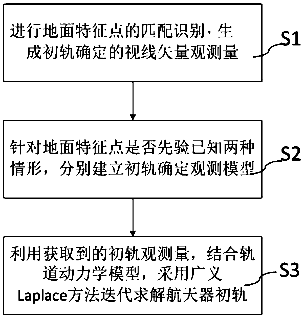
[0076] like figure 1 As shown, the present invention has improved a kind of autonomous initial orbit determination method based on remote sensing image, comprises the following steps:

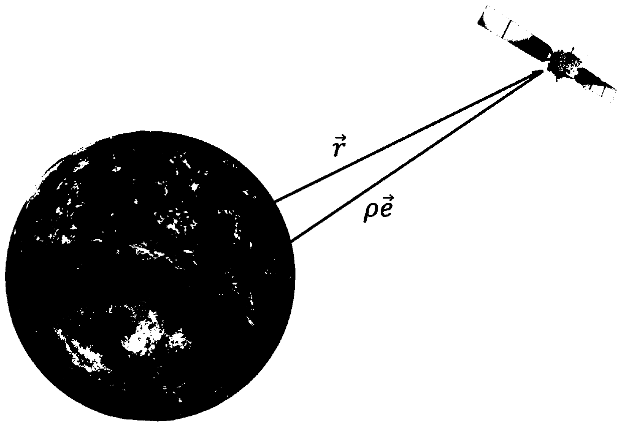
[0077] S1. Perform identification and matching of ground feature points, and generate line-of-sight vector observations determined by the initial orbit.

[...


PUM


Abstract

The invention discloses a spacecraft autonomous initial orbit determination method based on a remote sensing image. The spacecraft autonomous initial orbit determination method comprises the followingsteps of: S1, carrying out matching recognition of ground feature points in the remote sensing image, and generating a sight vector observed quantity for initial orbit determination; S2, aiming at whether the ground feature points are priori known or not, respectively establishing initial orbit determination observation models; and S3, iteratively solving an initial orbit of a spacecraft by adopting a generalized Laplace method in combination with an orbit dynamics model by utilizing the acquired initial orbit determination observed quantity. The spacecraft autonomous initial orbit determination method utilizes the feature information in the remote sensing image, derives orbit determination observation models under two conditions according to whether ground characteristic point information is priori known or not, and realizes autonomous initial orbit determination of the spacecraft by taking sight vectors at different moments as observed quantities. The autonomous initial orbit determination method provided by the invention is suitable for priori conditions of different features, has higher flexibility, and improves the reliability of on-orbit operation of the spacecraft.

Description

technical field [0001] The invention belongs to the field of spacecraft initial orbit determination, and in particular relates to a method for autonomous initial orbit determination of a spacecraft based on remote sensing images. Background technique [0002] In the orbit determination of spacecraft, it mainly relies on ground measurement and control means. As the number of spacecraft in orbit continues to grow, the amount of information transmission increases sharply, and the burden on ground measurement and control stations becomes heavier and heavier. As a result, the probability of errors and the cost of measurement and control also increase. In addition, relying on the ground station will increase the safety risk of the spacecraft when it encounters interference or communication and navigation system failure, and weaken the survivability of the spacecraft. Based on the above points, the autonomous orbit determination of spacecraft will be the future trend of aerospace ...

Claims


Application Information

Patent Timeline
Patent Type & Authority Applications(China)
IPC IPC(8): G01C21/24
CPCG01C21/24
Inventor 李木子孙俊彭杨王兆龙谭龙玉陈文
Owner SHANGHAI AEROSPACE CONTROL TECH INST
Why Eureka
Try Eureka