
River and lake shoreline sand mining monitoring and analyzing method and device

A technology of sand mining and river channel, applied in the direction of instruments, character and pattern recognition, electrical components, etc., can solve the problem of inability to realize automatic detection and labeling of large data sand mining points, inability to realize large amount of data analysis and rapid data selection, not considered Sand mining activities dynamic analysis unit and other issues, to achieve the effect of effective management, reduction of investigation work, and wide applicability

Active Publication Date: 2020-04-24
CHINA WATER RESOURCES BEIFANG INVESTIGATION DESIGN & RES
View PDF9 Cites 16 Cited by
  • Summary
  • Abstract
  • Description
  • Claims
  • Application Information

AI Technical Summary

Problems solved by technology

[0006] However, the existing technology has the following problems: without considering the satellite image screening unit covering the range of rivers and lakes, it is impossible to realize the necessary analysis of a large amount of data and the rapid selection of data; The automatic detection and labeling of positions; the dynamic analysis unit of sand mining activities cannot be easily and quickly realized the change analysis of sand mining activities in different periods; the forwarding function of sand mining analysis results is not considered, and the sand mining information cannot be reported quickly and conveniently To the river and lake protection management departments

Method used


Image

  • River and lake shoreline sand mining monitoring and analyzing method and device
  • River and lake shoreline sand mining monitoring and analyzing method and device
  • River and lake shoreline sand mining monitoring and analyzing method and device

Examples


Embodiment Construction

[0043] Below in conjunction with accompanying drawing and specific embodiment the present invention is described in further detail:

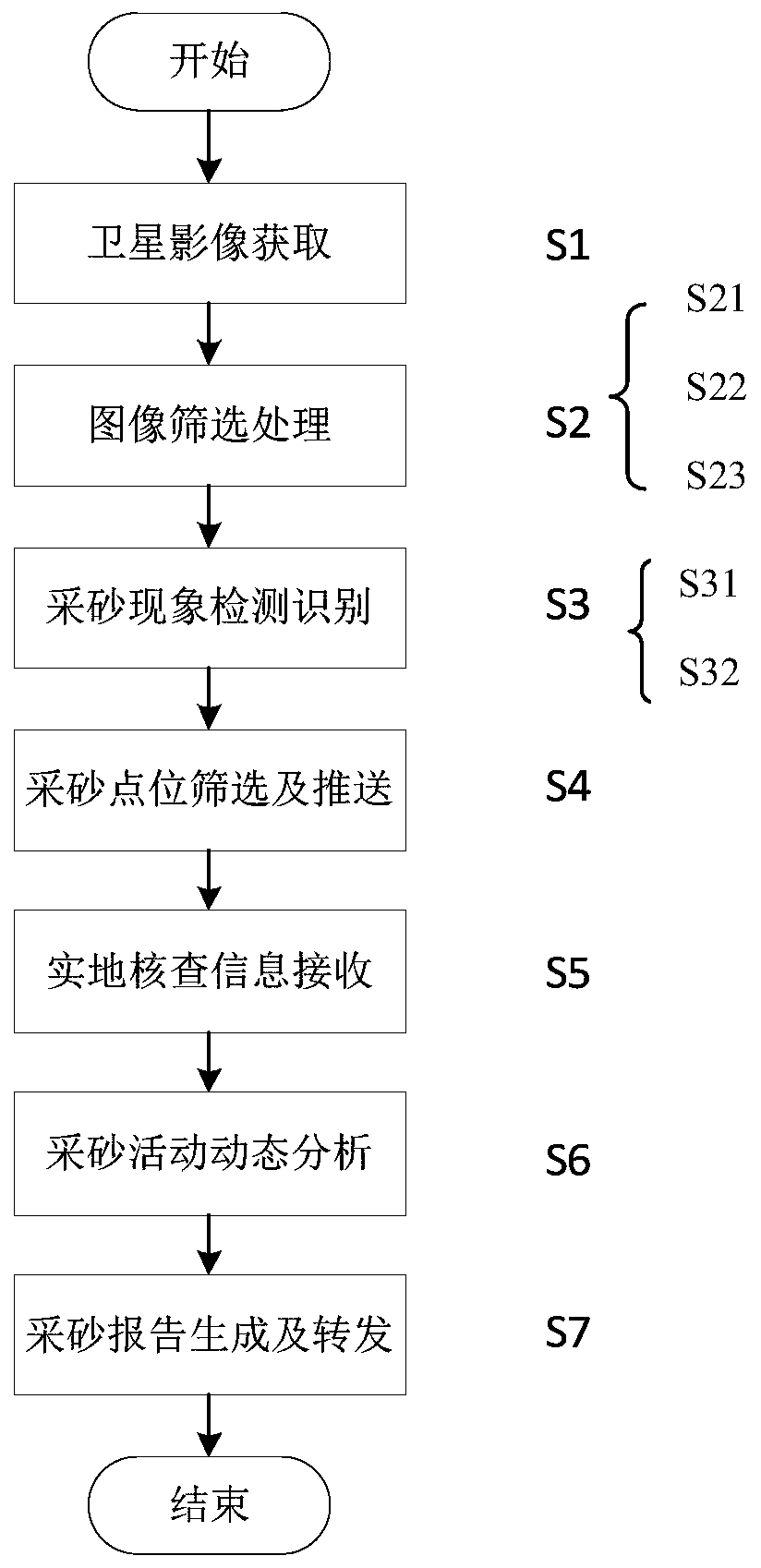
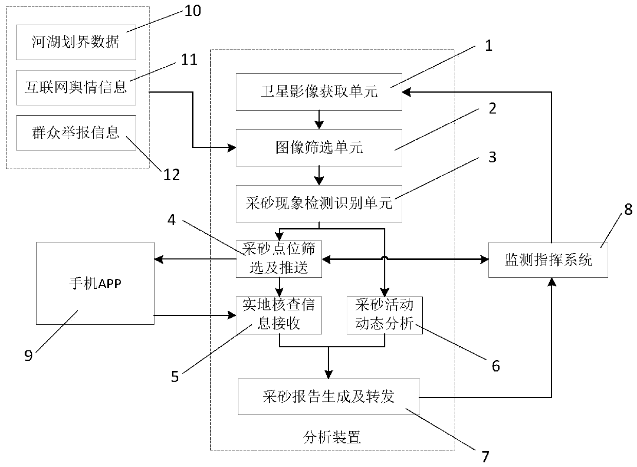
[0044] Such as figure 1 As shown, the method for sand mining monitoring and analysis of river and lake shorelines of the present invention includes: obtaining satellite image data of the range of river and lake shorelines; performing data range masking according to the management range of river and lake shorelines, and screening the waiting time according to time and space coverage. Processed satellite image data; establish a sand mining phenomenon recognition sample library, and train the model, use the trained model to perform intelligent detection and recognition of sand mining phenomenon on the satellite image data to be processed, and optimize the sand mining phenomenon recognition results ; Superimpose and analyze the intelligent detection and recognition results of sand mining phenomena of different periods of satellite image data to obta...


PUM


Abstract

The invention discloses a river and lake shoreline sand mining monitoring and analyzing method and device. The method comprises the steps of acquiring satellite image data in a river and lake shoreline range; performing data range masking according to the river and lake shoreline management range line, and screening to-be-processed satellite image data according to time and space coverage conditions; establishing a sand mining phenomenon recognition sample library, training a model, performing sand mining phenomenon intelligent detection and recognition on to-be-processed satellite image databy utilizing the trained model, and performing optimization processing on a sand mining phenomenon recognition result; carrying out superposition analysis on the sand mining phenomenon intelligent detection and identification results of the satellite image data in different periods to obtain a sand mining phenomenon change situation; pushing information to the field survey APP from the sand miningsuspected point location, and receiving field check information; and generating a sand mining analysis report, and forwarding the report to the monitoring command system. According to the invention,rapid screening is realized, the sand mining detection database is established by adopting the sand mining image data, automatic identification of sand mining phenomena with various forms is realized,and the working efficiency is improved.

Description

technical field [0001] The invention relates to the technical field of data processing in the water conservancy industry, in particular to a method and a device for monitoring and analyzing sand mining along river and lake shorelines. Background technique [0002] In recent years, with the continuous acceleration of urbanization, the "four chaos" problems of "random occupation, random mining, random piles, and random construction" have been repeatedly eliminated in the management of rivers and lakes in many cities. , Illegal reclamation of lakes (reservoirs), illegal sand mining and other water-related violations that seriously affect the water ecology and water environment occur from time to time, seriously affecting the ecological environment of rivers and lakes in cities and the happiness index of human settlements. The rectification of "four chaos" has become the main content of the supervision of urban rivers and lakes. [0003] At present, the investigation and rectif...

Claims


Application Information

Patent Timeline
Patent Type & Authority Applications(China)
IPC IPC(8): G06K9/00G06K9/62G06Q50/26H04L29/08
CPCG06Q50/26H04L67/125G06V20/182G06F18/214Y02A10/40
Inventor 刘满杰谢津平徐寅生奚歌刘金玉张福坤许健
Owner CHINA WATER RESOURCES BEIFANG INVESTIGATION DESIGN & RES
Learn More