Dynamic positioning method and system of submarine geophone and geophone

A geophone and dynamic positioning technology, applied in seismic signal receivers, seismology, seismology for areas covered by water, etc., can solve problems such as multiple offsets of geophones and imaging effect errors that are not considered

Active Publication Date: 2020-02-11
OCEAN UNIV OF CHINA +3
View PDF5 Cites 8 Cited by
  • Summary
  • Abstract
  • Description
  • Claims
  • Application Information

AI Technical Summary

Problems solved by technology

[0005] To sum up, the problems existing in the existing technology are: in all the current secondary positioning methods, the possibility of multiple offsets of the geophones is not considered, and the positions of the geophones are different in different time periods during the construction period. Thinking that the geophones are located in the same place from beginning to end, the final imaging effect will introduce errors

Method used


Image

  • Dynamic positioning method and system of submarine geophone and geophone
  • Dynamic positioning method and system of submarine geophone and geophone
  • Dynamic positioning method and system of submarine geophone and geophone

Examples


Embodiment Construction

[0036] In order to make the objectives, technical solutions and advantages of the present invention clearer, the present invention will be further described in detail below in conjunction with embodiments. It should be understood that the specific embodiments described herein are only used to explain the present invention, but not to limit the present invention.

[0037] In view of the problems existing in the prior art, the present invention provides a method, system and geophone for dynamic positioning of a seabed geophone. The present invention will be described in detail below with reference to the accompanying drawings.

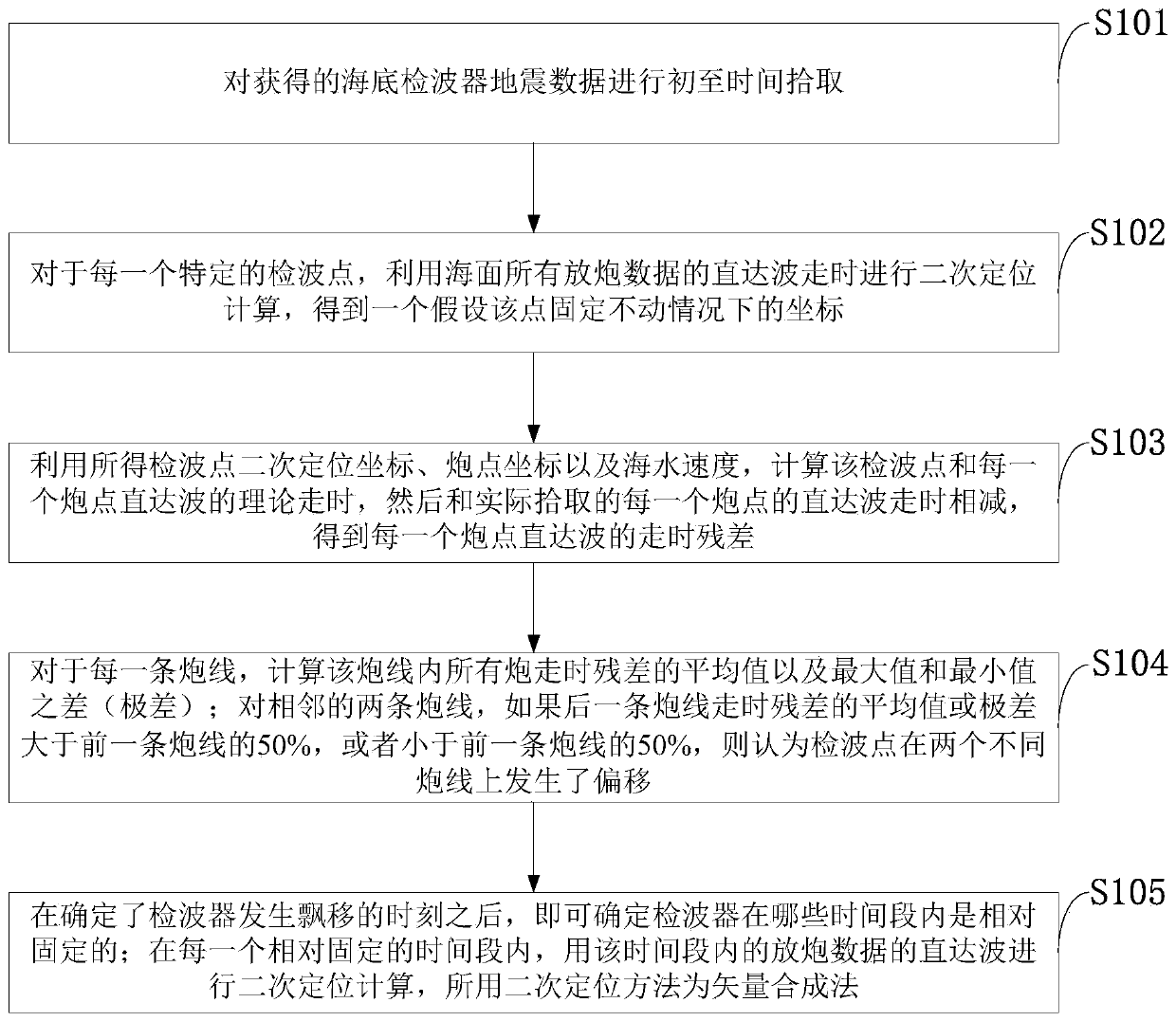
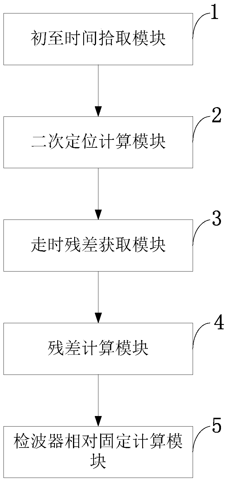
[0038] Such as figure 1 As shown, the method for dynamic positioning of a seabed geophone provided by an embodiment of the present invention includes the following steps:

[0039] S101: Pick up the first arrival time of the obtained seabed geophone seismic data;

[0040] S102: For each specific detection point, use the direct wave travel time of all the shot dat...


PUM


Abstract

The invention belongs to the technical field of ocean seismic exploration, and discloses a dynamic positioning method and system of a submarine geophone and the geophone. The dynamic positioning method comprises the steps of picking up first arrival time of submarine geophone seismic data; performing secondary positioning calculation on each special detection point according to direct wave traveltime of all shot data of a sea surface to obtain coordinate under the condition that the point is assumed to be fixed; calculating theoretical travel time of direct waves of the detection point and each shot point according to the obtained secondary positioning coordinate of the detection point, the coordinates of shot points and a seawater speed, and subtracting the theoretical travel time from direct wave travel time, actually picked up, of each shot point to obtain travel time residue of the direct wave of each shoot point; calculating an average value and a range of travel time residue ofall shots in each shot line; and determining a moment when the geophone moves according to an average value and a range of travel time residue of an adjacent shot line, and determining when the geophone is relatively fixed within certain time. By the dynamic positioning method, a foundation is laid for subsequent high-accuracy imaging.

Description

Technical field [0001] The invention belongs to the technical field of marine seismic exploration, and in particular relates to a method, system and geophone for dynamic positioning of a seabed geophone. Background technique [0002] At present, the closest existing technology: as offshore oil and gas exploration is gradually deepening, the geophones used in offshore oil and gas exploration have gradually developed submarine geophones from sea surface streamers, including submarine cables, submarine seismometers and submarine nodes. In the seismic survey of seabed nodes, the geophone needs to be placed on the seabed. Due to the influence of ocean currents, tides, biological activities, human fishing and other factors, the geophone may gradually deviate from the design position as the deployment time increases. This kind of deviation is sometimes very serious, and its uncertainty has a great influence on the collected data. If the seismic data is processed and interpreted accord...

Claims


Application Information

Patent Timeline
Patent Type & Authority Applications(China)
IPC IPC(8): G01V1/38G01V1/18
CPCG01V1/181G01V1/3808G01V1/3835G01V1/3852
Inventor 王忠成童思友李林伟王凯刘张聚
Owner OCEAN UNIV OF CHINA
Why Eureka
Try Eureka