High-precision navigation method, system, medium, and vehicle terminal based on vehicle-mounted camera device

A vehicle-mounted camera and navigation method technology, applied in the field of data processing, can solve problems such as untimely route reminders, inaccurate positioning, and wrong map data, and achieve the effects of improving user experience, avoiding matching errors, and accurate vehicle positioning.

Inactive Publication Date: 2020-01-21
SHANGHAI PATEO INTERNET TECH SERVICE CO LTD
View PDF10 Cites 3 Cited by
  • Summary
  • Abstract
  • Description
  • Claims
  • Application Information

AI Technical Summary

Problems solved by technology

[0005] (1) Inaccurate positioning often occurs due to GPS drift, Inertial Measurement Unit (IMU) measurement inaccuracy, etc., resulting in parallel road matching errors;
[0006] (2) Due to lack of map data, map data errors or map data errors, the actual driving track is inconsistent with the planned route, and the vehicle positioning cannot be accurately performed;
[0007] (3) When the road is closed due to maintenance and other reasons, it is impossible to obtain the road status change information in real time, resulting in the route reminder not being timely and causing inconvenience to the driver

Method used


Image

  • High-precision navigation method, system, medium, and vehicle terminal based on vehicle-mounted camera device
  • High-precision navigation method, system, medium, and vehicle terminal based on vehicle-mounted camera device
  • High-precision navigation method, system, medium, and vehicle terminal based on vehicle-mounted camera device

Examples


Embodiment Construction

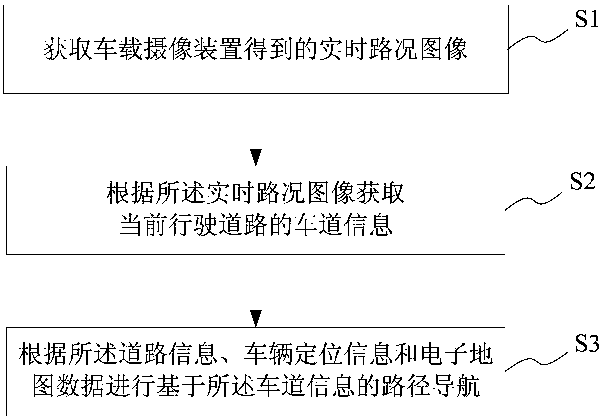
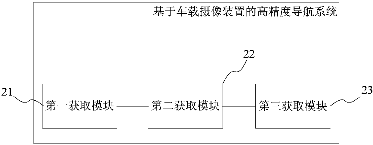
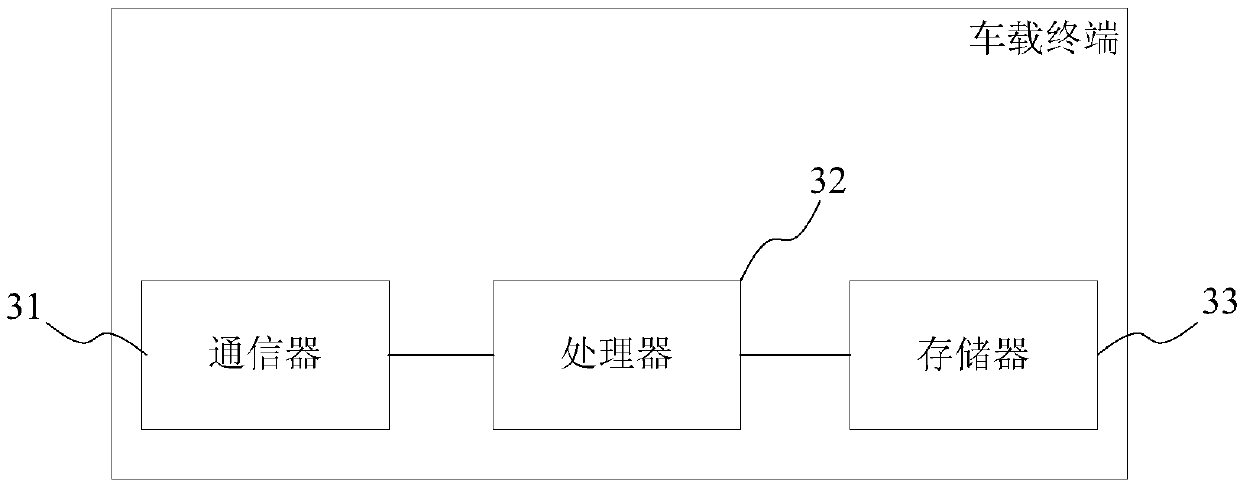
[0043] Embodiments of the present invention are described below through specific examples, and those skilled in the art can easily understand other advantages and effects of the present invention from the content disclosed in this specification. The present invention can also be implemented or applied through other different specific implementation modes, and various modifications or changes can be made to the details in this specification based on different viewpoints and applications without departing from the spirit of the present invention.

[0044] It should be noted that the diagrams provided in this embodiment are only schematically illustrating the basic idea of ​​the present invention, and only the components related to the present invention are shown in the diagrams rather than the number, shape and shape of the components in actual implementation. Dimensional drawing, the type, quantity and proportion of each component can be changed arbitrarily during actual impleme...


PUM


Abstract

The invention provides a high-precision navigation method, system, medium, and vehicle terminal based on a vehicle-mounted camera device. The method comprises the following steps: obtaining a real-time road condition image obtained by the vehicle-mounted camera device; obtaining lane information of a current driving road according to the real-time road condition image; and according to the road information, vehicle positioning information, and electronic map data, performing path navigation based on the lane information. According to the high-precision navigation method, system, medium, and vehicle terminal based on the vehicle-mounted camera device, more accurate navigation is performed according to real-time road condition information obtained by the vehicle-mounted camera device, whichgreatly improves the user experience.

Description

technical field [0001] The present invention relates to the technical field of data processing, in particular to a high-precision navigation method, system, medium, and vehicle-mounted terminal based on a vehicle-mounted camera device. Background technique [0002] Electronic map (Electronic map), that is, digital map, is a map that is stored and consulted digitally using computer technology. The method of storing information on electronic maps generally uses vector image storage, and the scale of the map can be enlarged, reduced or rotated without affecting the display effect. [0003] In the prior art, the vehicle-mounted navigation equipment uses the vehicle-mounted GPS (Global Positioning System) to coordinate with the electronic map for positioning and navigation. It can know the exact location of the vehicle anytime and anywhere while driving the vehicle, and can tell the driver where to go conveniently and accurately. The shortest or fastest path to the destination. ...

Claims


Application Information

Patent Timeline
Patent Type & Authority Applications(China)
IPC IPC(8): G01C21/28G01C21/34
CPCG01C21/28G01C21/3492
Inventor 穆允林李欢
Owner SHANGHAI PATEO INTERNET TECH SERVICE CO LTD
Why Eureka
Try Eureka