
A traffic command platform and its command method in high-risk areas based on UAV projection

A podium and unmanned aerial vehicle technology, which is applied to the traffic podium and its command field in high-risk areas, can solve the problems of traffic police life safety threats, traffic police life safety hazards, heavy physical burden, etc., achieve low delay and promote projection effect and realistic, responsive effects

Active Publication Date: 2021-08-27
徐州奥拉可电子科技有限公司
View PDF33 Cites 0 Cited by
  • Summary
  • Abstract
  • Description
  • Claims
  • Application Information

AI Technical Summary

Problems solved by technology

[0007] At present, the traffic conditions in complex areas, especially road intersections, are relatively complicated. It is difficult to direct traffic in real time and orderly by relying only on traffic lights, and improve congestion. The traffic accident rate at intersections is high. Set up a traffic command platform, and a special traffic police station will conduct real-time command on the passing vehicles. Since the traffic police can make real-time adjustments according to the traffic conditions, it has the incomparable advantages of traffic lights, including real-time and authoritative, so The scene of the traffic police standing on the traffic podium in the middle of the road is not uncommon in various cities in our country. It has become a beautiful landscape in the city, but behind this, the traffic police have a heavy burden on their physical strength besides enduring the hot and cold weather. , and the command effect is poor in bad weather. The most important thing is that the traffic police actually have great hidden dangers to life safety. Security is a great threat

Method used


Image

  • A traffic command platform and its command method in high-risk areas based on UAV projection
  • A traffic command platform and its command method in high-risk areas based on UAV projection
  • A traffic command platform and its command method in high-risk areas based on UAV projection

Examples


Embodiment 1

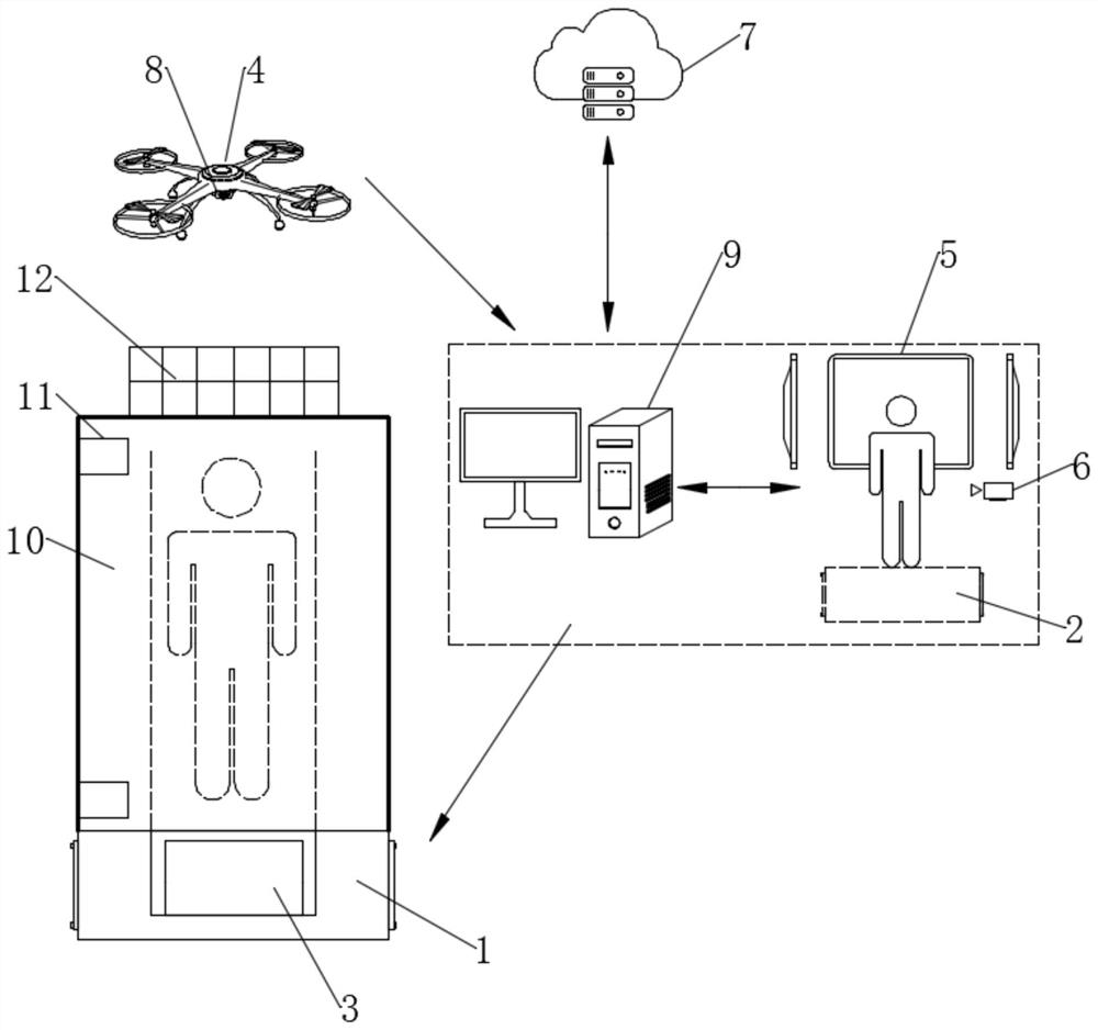
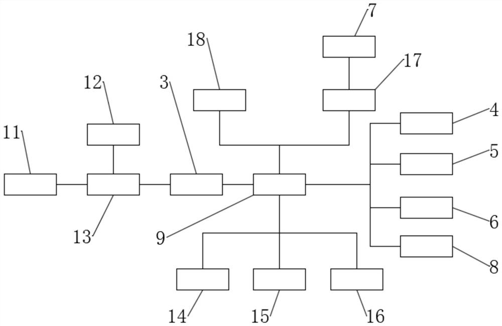
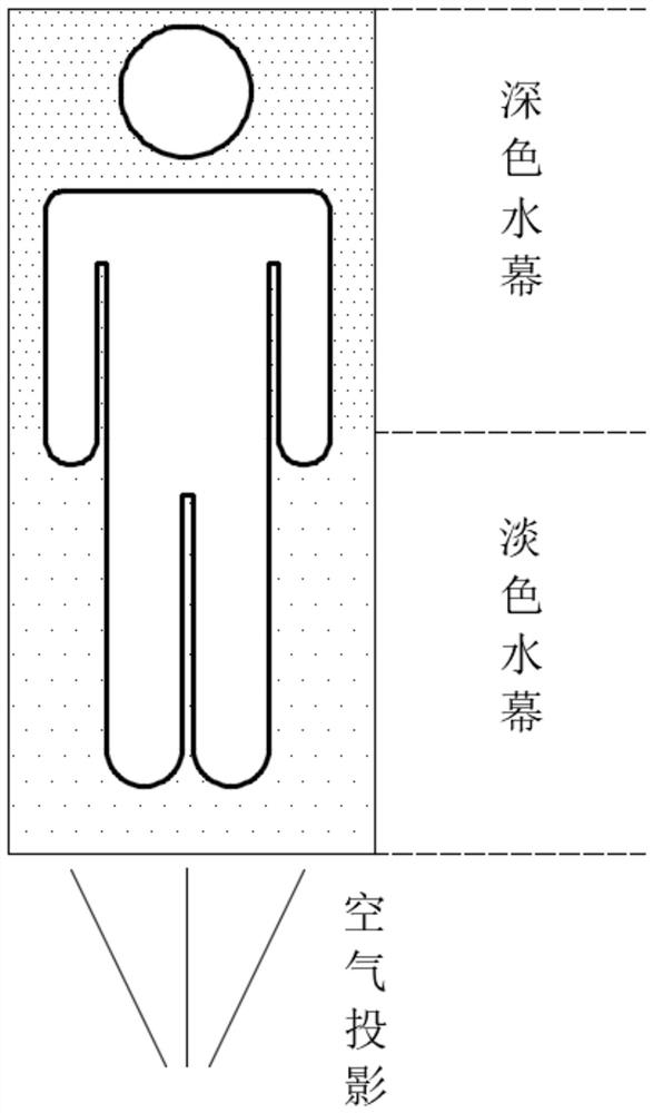
[0047] see Figure 1-2 , a high-risk area traffic control platform based on UAV projection, including a front control platform 1 and a rear control platform 2, an electronic slot is dug on the upper end of the front control platform 1, which can be shielded and protected, and an air imaging projection module is installed in the electronic slot 3 and the first power supply module 13, and the air imaging projection module 3 is electrically connected to the first power supply module 13, and the upper end of the front podium 1 is fixedly connected with a protective glass cover 10, which is cylindrical and plays a role in blocking The role of protection, on the other hand, can maintain the internal projection environment from being disturbed by the outside world. The protective glass cover 10 is made of transparent tempered glass, and the surface is covered with an anti-reflective film, and the surface of the anti-reflective film is coated with a nano-waterproof coating. On the one...


PUM


Abstract

The invention discloses a high-risk area traffic command platform based on UAV projection and a command method thereof, which can realize the setting of a conspicuous front command platform in the middle of the road in a high-risk area, and a safe rear command platform in a nearby safe position. And the remote control drone in the sky monitors the surrounding vehicle conditions in real time, and the monitoring video is sent back to the rear command platform in real time, and displayed to the traffic police on the rear command platform in the form of simulation. The traffic police can conduct targeted and effective command on the scene according to the monitoring content At the same time, through the whole process of video recording, it is transmitted to the front command platform for air projection after video processing, and the real-time command of the traffic police in the rear is projected to the front. At the same time, the effect of the auxiliary sprayer is greatly improved. It clearly captures the projected command content, and has the characteristics of low delay and fast response. On the premise of ensuring effective traffic command, the life safety of traffic police is guaranteed to the greatest extent.

Description

technical field [0001] The invention relates to the technical field of traffic command, more specifically, to a high-risk area traffic command platform based on UAV projection and a command method thereof. Background technique [0002] Traffic control, also called traffic signal control, or urban traffic control, is to rely on traffic police or use traffic signal control facilities to direct the passage of vehicles and pedestrians according to the characteristics of traffic changes. [0003] Traffic control uses modern communication facilities, signal devices, sensors, monitoring equipment and computers to accurately organize and regulate running vehicles so that they can run safely and smoothly. Traffic control is divided into static management and dynamic management, and traffic control is one of the dynamic management. [0004] Traffic control restricts, adjusts, induces, and diverts traffic flow through traffic control facilities managed by electronic computers to achie...

Claims


Application Information

Patent Timeline
Patent Type & Authority Patents(China)
IPC IPC(8): G08G1/09G08G1/01H04N7/18H04L29/08G03B21/608G09F19/18
CPCG03B21/608G08G1/012G08G1/09G09F19/18H04L67/1097H04N7/181
Inventor 颜丙磊刘浩
Owner 徐州奥拉可电子科技有限公司
Learn More