Transmission corridor tree barrier monitoring system based on aerial remote sensing
A monitoring system and aerial remote sensing technology, applied in radio wave measurement systems, control/regulation systems, measurement devices, etc., can solve problems affecting the normal operation of the power grid and normal operation, and achieve objective results and reduce workload.
- Summary
- Abstract
- Description
- Claims
- Application Information
AI Technical Summary
Problems solved by technology
Method used
Image
Examples
Embodiment Construction
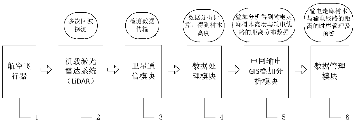
[0019] Such as figure 1 As shown, the present invention builds a tree barrier monitoring system for power transmission corridors based on aviation remote sensing, relies on the airborne LiDAR (2) carried by the aviation vehicle (1) to carry out multiple echo detection of trees on the ground surface in a wide area, and passes the detection results through The communication module (3) transmits the data processing module (4) to the ground through the analysis and calculation of the surface digital elevation model (DEM) and the canopy surface digital model (DSM) to obtain the regional tree height distribution data, and then the regional tree height distribution data Input grid transmission GIS overlay analysis module (5) to perform overlay analysis to obtain the distance between transmission corridor trees and transmission lines, and input the overlay analysis results into data management module (6) to realize the time series change of the distance between transmission corridor tr...
PUM
 Abstract
Description
Claims
Application Information
 - Generate Ideas
- Intellectual Property
- Life Sciences
- Materials
- Tech Scout
- Unparalleled Data Quality
- Higher Quality Content
- 60% Fewer Hallucinations
Browse by: Latest US Patents, China's latest patents, Technical Efficacy Thesaurus, Application Domain, Technology Topic, Popular Technical Reports.
© 2025 PatSnap. All rights reserved.Legal|Privacy policy|Modern Slavery Act Transparency Statement|Sitemap|About US| Contact US: help@patsnap.com

