Solar altitude simulation analysis method and system of sub-satellite point

A technology of sun altitude angle and simulation analysis, applied in the field of sun altitude angle simulation analysis of satellite sub-satellite point, can solve the problems of sun altitude angle accuracy error, low accuracy of calculation results, deviation, etc., to achieve the effect of improving accuracy

Active Publication Date: 2019-09-10
锡创索科技(苏州)有限公司
View PDF5 Cites 2 Cited by
  • Summary
  • Abstract
  • Description
  • Claims
  • Application Information

AI Technical Summary

Problems solved by technology

The disadvantage of this method is that the solar declination angle and solar hour angle are calculated based on empirical formulas, without considering the real-time changes in the sun's position, and there will be deviations between the calculated results and the actual values, resulting in low accuracy of the calculated results of the solar altitude angle.
[0003] In the existing method for obtaining the sun altitude angle of optical remote sensing satellites, the solar declination angle and solar hour angle obtained according to the empirical formula are used in the calculation formula of the sun altitude angle, and the real-time change of the sun position is not considered, resulting in the calculation of the solar altitude angle. There is a precision error in the altitude angle, which makes it impossible to provide accurate input for the adjustment of the space camera parameters

Method used


Image

  • Solar altitude simulation analysis method and system of sub-satellite point
  • Solar altitude simulation analysis method and system of sub-satellite point
  • Solar altitude simulation analysis method and system of sub-satellite point

Examples


Embodiment Construction

[0025] In order to make the objectives, technical solutions and advantages of the embodiments of the present invention clearer, the following will clearly and completely describe the technical solutions in the embodiments of the present invention in conjunction with the accompanying drawings in the embodiments of the present invention. Obviously, the described embodiments It is a part of the embodiments of the present invention, not all the embodiments. Based on the embodiments of the present invention, all other embodiments obtained by those of ordinary skill in the art without creative work shall fall within the protection scope of the present invention.

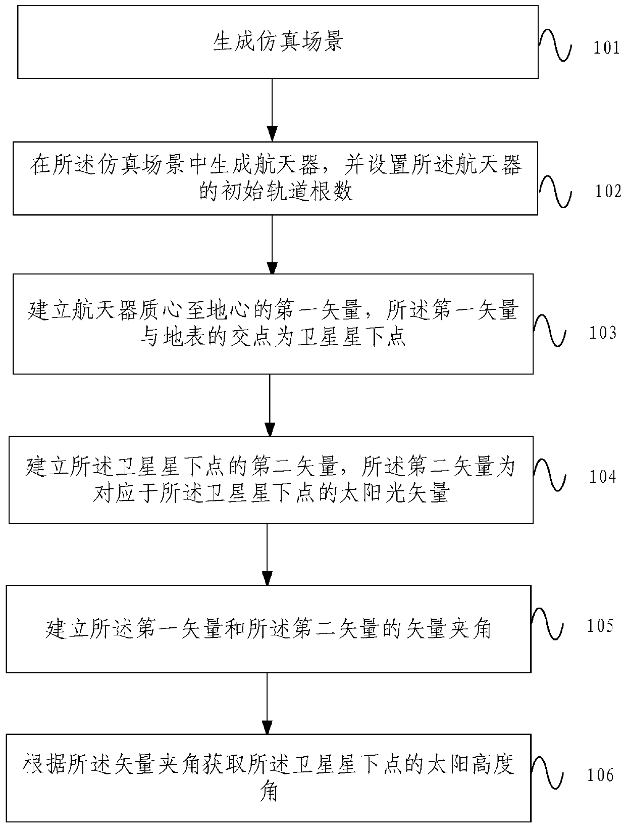
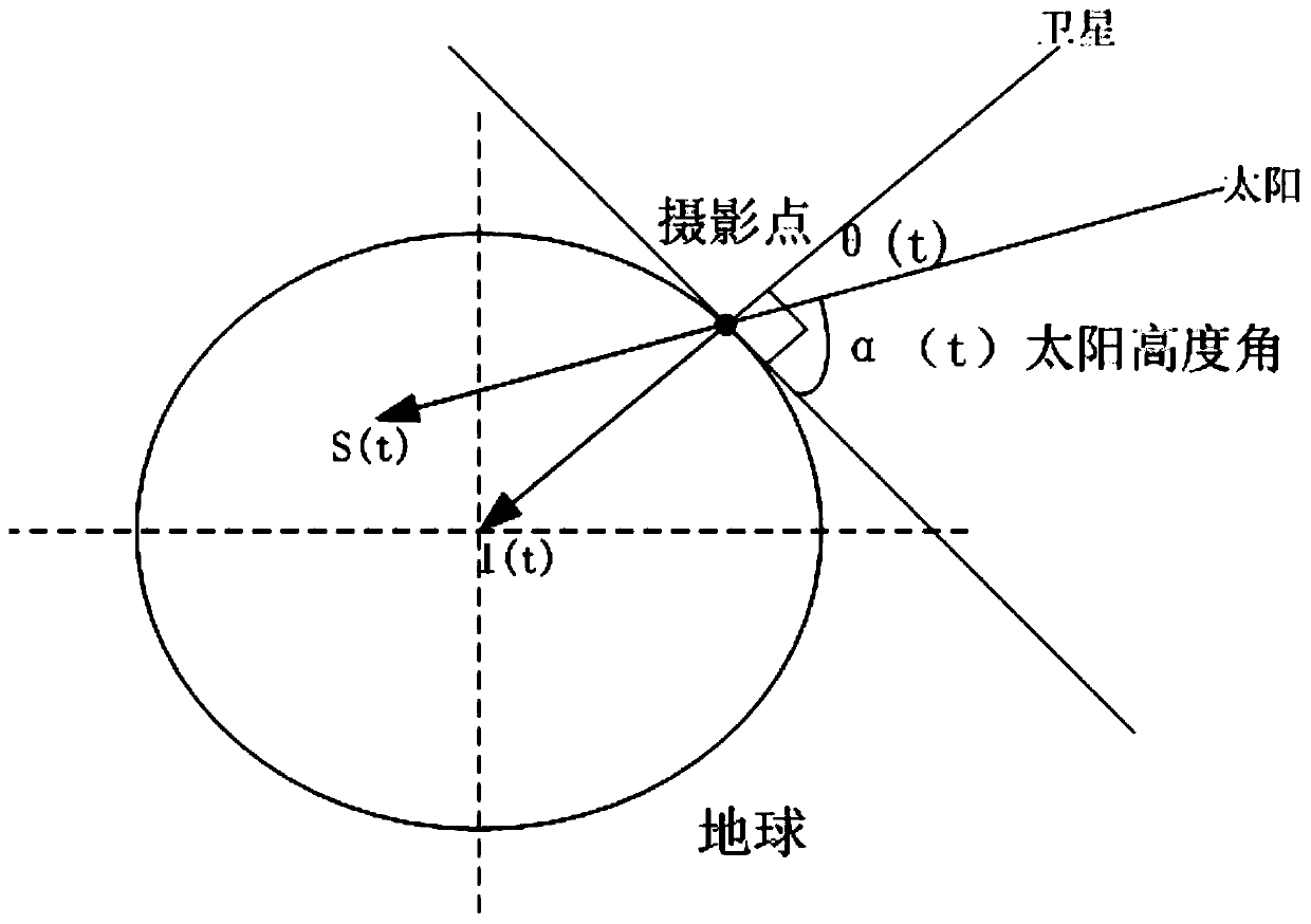
[0026] figure 1 It is a flowchart of a method for simulation and analysis of the altitude angle of the sun under the satellite provided by an embodiment of the present invention. figure 2 It is a schematic diagram of the calculation principle of the solar altitude angle in the simulation analysis method of the satellite under...


PUM


Abstract

The embodiment of the invention provides a solar altitude simulation analysis method and system of a sub-satellite point. The method comprises the steps of: generating a simulation scene; generating aspacecraft in the simulation scene, and setting the initial orbit elements of the spacecraft; establishing the first vector from the mass centre of the spacecraft to the centre of the earth, whereinthe intersection point between the first vector and the earth's surface is the sub-satellite point; establishing the second vector of the sub-satellite point, wherein the second vector is the sunlightvector corresponding to the sub-satellite point; establishing the vector included angle between the first vector and the second vector; and, obtaining the solar altitude of the sub-satellite point according to the vector included angle. According to the embodiment of the invention, simulation, analysis and calculation on the solar altitude in a satellite running process can be realized; the change problem of the photography point position and the sun position running along with the satellite can be solved; the solar altitude calculation precision is increased; and thus, effective design basisis provided for parameter adjustment of a space camera in a satellite design stage and a factor test stage.

Description

Technical field [0001] The invention relates to the technical field of satellite applications, in particular to a simulation analysis method and system for the altitude angle of the sun under the satellite. Background technique [0002] Optical remote sensing satellites have been widely used in the fields of land and resources management, environmental monitoring, land use, urban planning, and emergency response to disasters. They generally acquire remote sensing images by carrying one or more high-resolution earth observation space cameras. The sun altitude angle of the ground photography point is an important basis for the on-orbit adjustment of the space camera parameters, and its accuracy directly affects the correctness of the camera parameter adjustment. For a certain place on the earth, the solar altitude angle refers to the angle between the incident direction of the sun's rays and the ground plane. In professional terms, the solar altitude angle refers to the surface sec...

Claims


Application Information

Patent Timeline
Patent Type & Authority Applications(China)
IPC IPC(8): G01C1/00
CPCG01C1/00
Inventor 黄群东杨佳文杨炜平孔飞飞
Owner 锡创索科技(苏州)有限公司
Why Eureka
Try Eureka