
Method for determining forest grass vegetation coverage threshold capable of restraining sand production in drainage basin

A technology of vegetation coverage and coverage, which is applied in special data processing applications, instruments, and electronic digital data processing, etc., can solve the limitations of research on sediment yield, the lack of watershed or regional scale research, and the inability to quantify vegetation changes and changes in the Loess Plateau. Problems such as the relationship between sediment yield in the river basin, etc., to achieve the effect of easy operation, large coverage area and wide range

Active Publication Date: 2019-08-30
黄河流域水土保持生态环境监测中心 +1
View PDF2 Cites 2 Cited by
  • Summary
  • Abstract
  • Description
  • Claims
  • Application Information

AI Technical Summary

Problems solved by technology

However, in general, the current research mainly makes a simple qualitative analysis of the relationship between the two, and there are relatively few studies on the quantitative relationship and threshold between the vegetation change of the Loess Plateau and the sediment yield of the watershed; The determination method of the vegetation coverage threshold is mainly based on the observation data of runoff plots. There are relatively few studies on large watersheds or regional scales. In addition, current research techniques continue traditional research methods, and it is impossible to quantify loess The relationship between plateau vegetation change and watershed sediment yield, which limits the research on the threshold of vegetation coverage that can curb sediment yield

Method used


Image

  • Method for determining forest grass vegetation coverage threshold capable of restraining sand production in drainage basin
  • Method for determining forest grass vegetation coverage threshold capable of restraining sand production in drainage basin
  • Method for determining forest grass vegetation coverage threshold capable of restraining sand production in drainage basin

Examples


Embodiment Construction

[0029] The technical scheme of the present invention will be further explained below in conjunction with examples. The invention relates to a method for effectively curbing the threshold value of the forest and grass vegetation coverage rate of sand production in a watershed, which can quantitatively describe the sand reduction benefit of the vegetation coverage rate and effectively avoid the limitation on the scale.

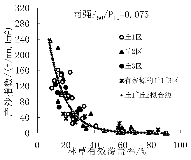
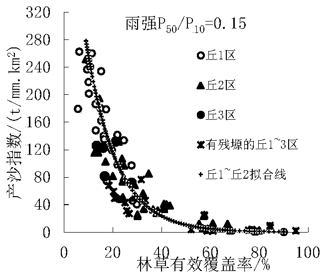
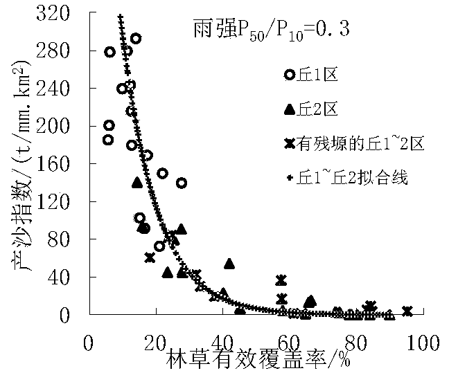
[0030] The present invention uses remote sensing images to obtain data such as forest and grassland, and combines natural rainfall data to obtain forest and grass coverage and sediment yield index, and analyzes the influence law of forest and grass vegetation changes on watershed sediment yield under different landforms, spatial scales, and rainfall conditions in the Loess Plateau, and then At the watershed scale, a threshold of forest and grass vegetation coverage that can effectively curb sediment production in the watershed is proposed. This method can not only q...


PUM


Abstract

The invention discloses a method for determining a forest grass vegetation coverage threshold capable of restraining sand production in a drainage basin. A remote sensing image is utilized to carry out the complete coverage data acquisition on an easily-eroded area of the loess plateau, the rule of influence of the forest grass vegetation change on the sand production in the drainage basin is analyzed in combination with the data of all years, and the sand production threshold values are obtained, so that the forest grass effective coverage rate threshold values under different regions and different rain intensities are obtained, and further the forest grass vegetation coverage rate threshold value capable of effectively restraining the sand production in the drainage basin is proposed onthe drainage basin scale. The method not only can quantitatively describe the sand reduction benefit of the vegetation coverage rate, but also can effectively avoid the scale limitation, and based onthe thought, even can gradually research, popularize and apply the research of the watershed scale to the landscape scale, the global scale and the regional scale.

Description

Technical field [0001] The invention belongs to the field of data collection and analysis, and specifically relates to the collection, processing and analysis of rainfall, water and sand, vegetation and terrace data in the erodible area of ​​the Loess Plateau. Background technique [0002] The Loess Plateau is one of the areas with the most serious soil erosion in my country, and it is also the main source of sediment in the Yellow River. Rainfall, soil, topography and vegetation are the key factors that determine the sediment yield in the watershed, and changes in any of these factors may aggravate or slow down soil erosion. At present, it is difficult to change natural factors such as rainfall, macro-topography, and soil composition, but it is possible to change the degree of vegetation coverage and micro-topography to affect sediment production in the watershed. In recent years, the vegetation coverage of the Loess Plateau has been greatly improved, and the sediment influx ha...

Claims


Application Information

Patent Timeline
Patent Type & Authority Applications(China)
IPC IPC(8): G06F17/50
CPCG06F30/20
Inventor 刘晓燕马宁党素珍高云飞岳本江
Owner 黄河流域水土保持生态环境监测中心
Learn More