


Quick Research
Generate reliable direction feasibility study reports for your R&D in just a few steps.

Technical Q&A
Discover and master advanced knowledge NOW. Basics, ideas, possibilities, all at once.

Find Solutions
As an expert in R&D theories, this can generate solutions to your technical problems instantly.

Evaluate Feasibility
Analyze your overall solution with one click, know your potential R&D risks in advance.

Monitor Landscape
Get weekly tech updates, stay abreast of the latest tech innovations and key insights.
A remote sensing image ship target detection method based on sparse mobilenetv2 network
A remote sensing image and target detection technology, which is applied in the field of remote sensing image ship target detection, can solve the problems of redundant remote sensing image information, large amount of remote sensing image data information, and difficulties in real-time analysis of satellites in orbit.
- Summary
- Abstract
- Description
- Claims
- Application Information
AI Technical Summary
Problems solved by technology
Method used
Image


Examples
specific Embodiment approach 1
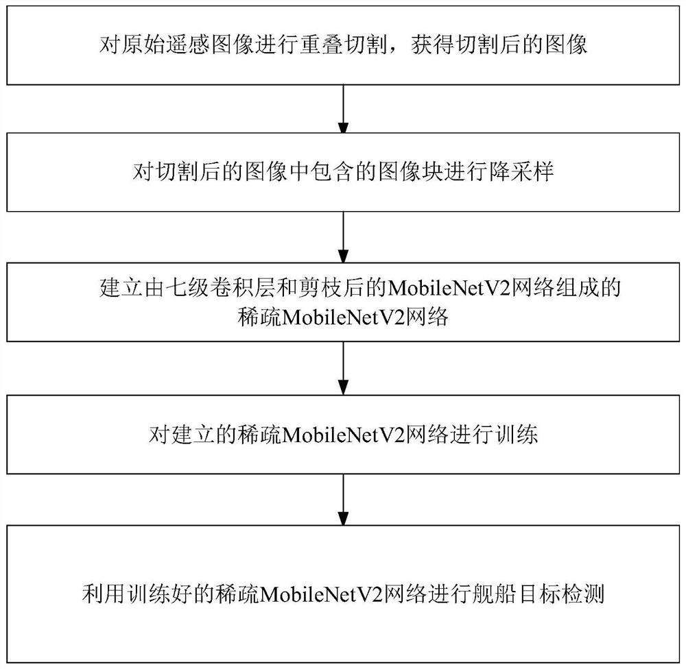
[0018] Specific implementation mode one: as figure 1 As shown, a remote sensing image ship target detection method based on a sparse MobileNetV2 network described in this embodiment, the method includes the following steps:
[0019] Step 1. Carry out overlapping cutting on the original remote sensing image according to the overlapping ratio α to obtain the cut image;
[0020] Step 2, downsampling the image block in the cut image in step 1, to obtain the downsampled image block;
[0021] Step 3. Establish a sparse MobileNetV2 network consisting of a seven-level convolutional layer and a pruned MobileNetV2 network;
[0022] And use the down-sampled image blocks in step 2 to train the seven-level convolutional layer, and use the image blocks in the cut image in step 1 to train the pruned MobileNetV2 network. When the number of training times reaches the set maximum number of iterations Stop iterating when , and obtain the trained sparse MobileNetV2 network;
[0023] Step 4. Fo...
specific Embodiment approach 2
[0027] Specific implementation mode two: the difference between this implementation mode and specific implementation mode one is: the specific process of the step one is:
[0028] According to the overlapping ratio α, the original remote sensing image with a size of 16k×16k pixels is overlapped and segmented to obtain the segmented image; in the segmented image, the size of each image block is 512×512 pixels.
[0029] The purpose of this embodiment is to make the ship target account for more than one-third of the small block image where it is located, and the purpose of overlapping is to ensure the integrity of the target and improve the accuracy of detection. Such as Figure 5 Shown is a schematic diagram of overlapping segmentation of the original remote sensing image.
specific Embodiment approach 3
[0030] Embodiment 3: This embodiment is different from Embodiment 2 in that: the image block included in the cut image is down-sampled, and the down-sampling method is a bilinear interpolation method.
[0031] The specific process of downsampling in this embodiment is as follows: the downsampling adopts the existing bilinear interpolation method, which is also called quadratic linear interpolation method. It uses the pixel values of the corresponding four points in the original image to determine the pixel values in the target image.
[0032] pseudocode
[0033] enter:
[0034] Img: original image
[0035] zmf: zoom factor
[0036] output:
[0037] new_img: output image
[0038] Step1: Find the size of the original image Img, which is recorded as height×width×channel, and then generate a matrix new_img with all 0s whose size is (zmf×height)×(zmf×width)×channel;
[0039] Step2: Extend the boundary of Img to get IT, the size is (height+2)×(width+2)×channel;
[0040] S...
PUM
 Abstract
Description
Claims
Application Information
 - R&D Engineer
- R&D Manager
- IP Professional
- Industry Leading Data Capabilities
- Powerful AI technology
- Patent DNA Extraction
Browse by: Latest US Patents, China's latest patents, Technical Efficacy Thesaurus, Application Domain, Technology Topic, Popular Technical Reports.
© 2024 PatSnap. All rights reserved.Legal|Privacy policy|Modern Slavery Act Transparency Statement|Sitemap|About US| Contact US: help@patsnap.com