A joint change detection method for extracting abandoned land from remote sensing

A technology of change detection and wasteland, applied in the direction of instruments, calculations, character and pattern recognition, etc., can solve the problems of non-cultivated land change noise impact, difficulty in ensuring large-area temporal and spatial coverage, complex land cover, etc., and achieve the effect of reducing noise interference

Active Publication Date: 2020-07-24
中国土地勘测规划院
View PDF5 Cites 0 Cited by
  • Summary
  • Abstract
  • Description
  • Claims
  • Application Information

AI Technical Summary

Problems solved by technology

[0004] However, the premise of the first classification method based on remote sensing images is that abandoned land must be significantly different from other land types. In reality, abandoned land has complex land cover and low sample separability, and it is easy to be compared with bare land and grassland. , shrubs and other land types mixed
The premise of the second type of change detection method is that the cultivated land is abandoned during the monitoring period, and it is powerless to do anything about the abandoned land that has occurred before the monitoring period, and is easily affected by the noise of non-cultivated land change.
In addition, the remote sensing data itself has certain limitations. The spatial resolution of low- and medium-score data is low, which is not enough to extract abandoned land; cloud disturbance
In addition, there are many types of abandoned land (completely abandoned, semi-abandoned, and transitional abandoned), and the crop characteristics and planting systems in different regions are also different. Therefore, there are many difficulties in accurately extracting abandoned land with the above-mentioned traditional methods.

Method used


Image

  • A joint change detection method for extracting abandoned land from remote sensing
  • A joint change detection method for extracting abandoned land from remote sensing
  • A joint change detection method for extracting abandoned land from remote sensing

Examples


Embodiment Construction

[0063] In order to make the content of the present invention clearer and easier to understand, the content of the present invention will be described in detail below in conjunction with specific embodiments and accompanying drawings.

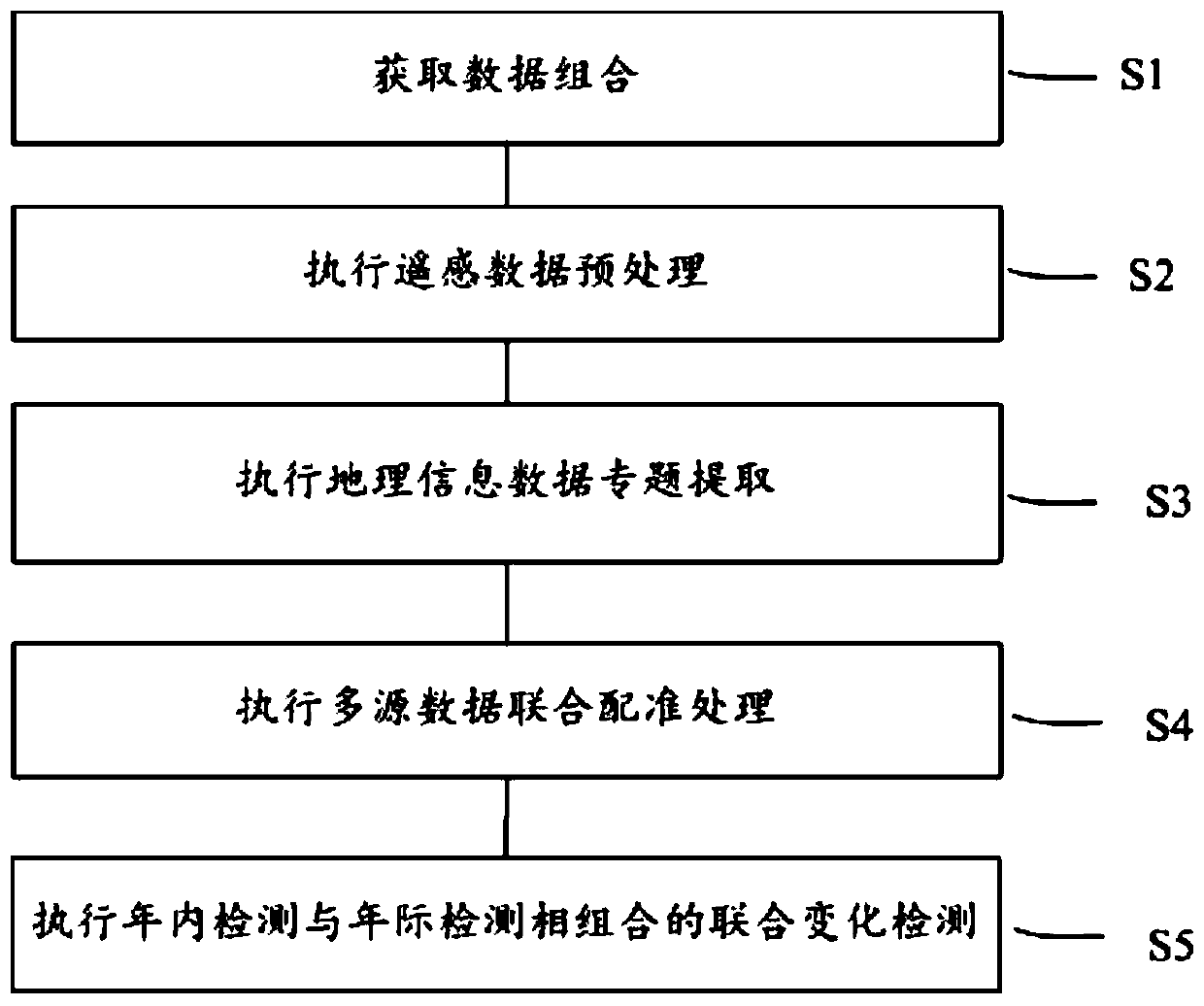
[0064] figure 1 Schematically shows a flow chart of a joint change detection method for remote sensing extraction of abandoned land according to a preferred embodiment of the present invention.

[0065] Such as figure 1 As shown, the joint change detection method for extracting abandoned land by remote sensing according to a preferred embodiment of the present invention includes:

[0066] The first step S1: Obtain a data combination, wherein the data combination includes: high-temporal and spatial remote sensing data under the full coverage of the target monitoring area within the target monitoring period, land use data within the target monitoring period, and conversion of farmland to forestry within the target monitoring period , and the cul...


PUM


Abstract

The invention provides a joint change detection method for extracting abandoned land by remote sensing, which includes acquiring data combination, performing preprocessing of remote sensing data, performing thematic extraction of geographical information data, performing joint registration processing of multi-source data, and performing intra-year detection and inter-year detection Combined five steps for joint change detection. The method of the invention not only improves the extraction accuracy of the abandoned land, so that the total extraction accuracy is as high as 97.6%, but also can effectively distinguish the types of the abandoned land. The invention provides the necessary information basis and technical system for investigating and studying the temporal and spatial evolution of abandoned land and directional improvement of the management method of abandoned land.

Description

technical field [0001] The invention relates to the field of abandoned land detection, in particular to a joint change detection method for extracting abandoned land by remote sensing. Background technique [0002] The Food and Agriculture Organization of the United Nations predicts that the total world population will increase to 9.1 billion in 2050, so it is necessary to increase global food production by 70% within 40 years to meet the needs of population growth. At the same time, with the improvement of living standards, the per capita consumption of agricultural products dominated by meat is also increasing. The demand for agricultural products will continue to rise worldwide, and under this background, the abandonment of cultivated land has gradually become a serious problem. The negative impacts of abandoned land include: reducing food production, causing irreversible losses of traditional cultivation forms, destroying rural landscapes, affecting farmers' income, cau...

Claims


Application Information

Patent Timeline
Patent Type & Authority Patents(China)
IPC IPC(8): G06K9/46G06K9/00
CPCG06V20/188G06V10/50
Inventor 杨通韩圣其郭旭东岳德鹏于潇张智杰汪晓帆吴丹周奥翟文馨
Owner 中国土地勘测规划院
Why Eureka
Try Eureka