
Distributed processing method/system for high-resolution satellite remote sensing data and medium

A distributed processing, high-resolution satellite technology, applied in the field of satellite communications, can solve the problem of unable to download data processing, only meet the download of historical data and products, etc., achieve rapid completion of computing processing, improve speed, reduce reading and writing effect of time

Active Publication Date: 2019-04-19
SHANGHAI ADVANCED RES INST CHINESE ACADEMY OF SCI
View PDF3 Cites 3 Cited by
  • Summary
  • Abstract
  • Description
  • Claims
  • Application Information

AI Technical Summary

Problems solved by technology

[0004] In view of the shortcomings of the prior art described above, the purpose of the present invention is to provide a distributed processing method / system and medium for high-resolution satellite remote sensing data, which is used to solve the problem that most of the existing high-resolution satellite remote sensing product production methods are carried out Small-scale production or large-scale production for a long time only satisfies the download of historical data and products, resulting in the inability to process the downloaded data in a timely manner

Method used


Image

  • Distributed processing method/system for high-resolution satellite remote sensing data and medium
  • Distributed processing method/system for high-resolution satellite remote sensing data and medium
  • Distributed processing method/system for high-resolution satellite remote sensing data and medium

Examples


Embodiment 1

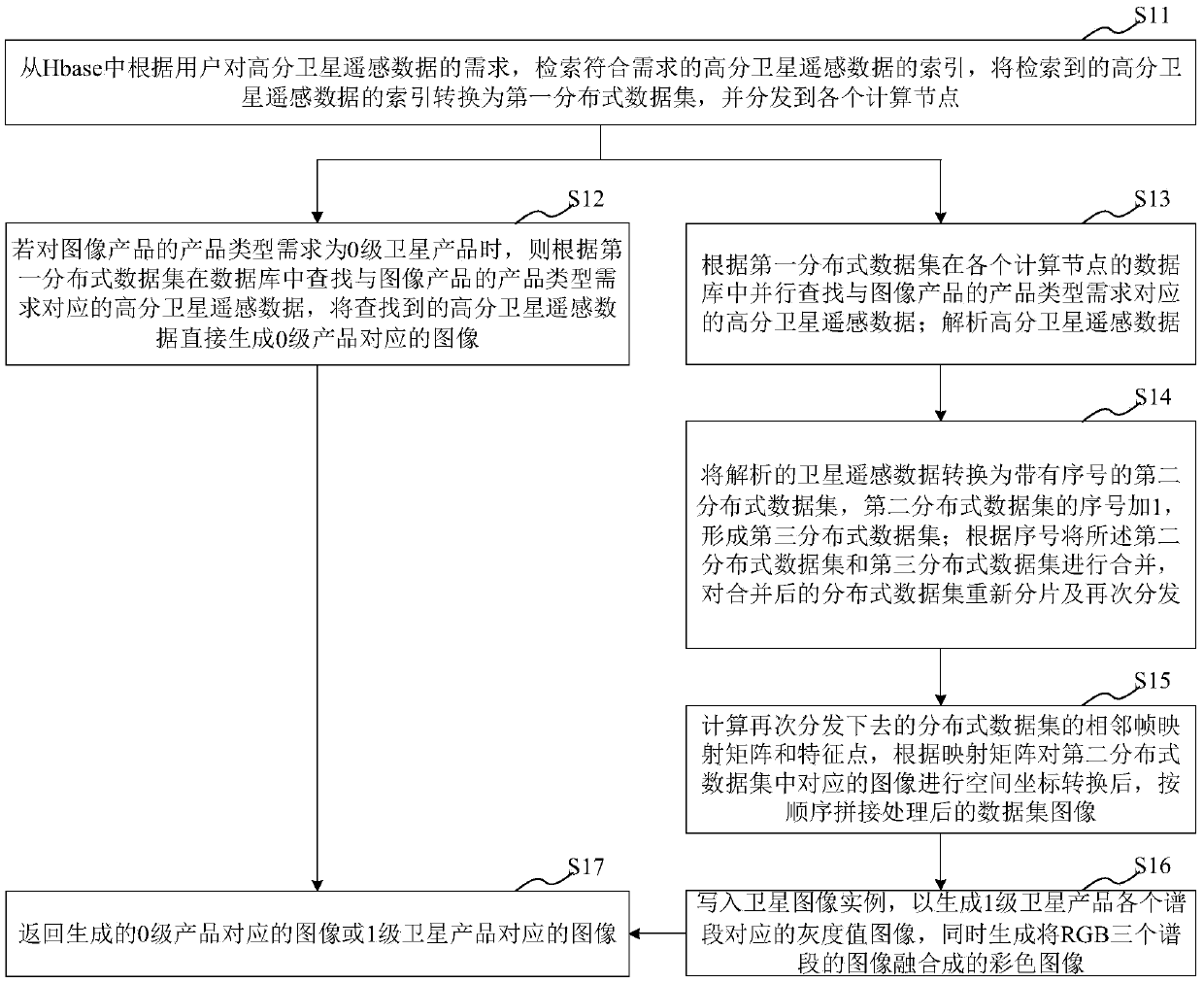
[0032] This embodiment provides a distributed processing method for high-resolution satellite remote sensing data. Before executing the processing method, the client obtains the requirements of the high-resolution satellite remote sensing data selected by the user and the product parameters of the image product, and creates a distributed The data processing task is to submit to the satellite data processing and product production platform to process high-resolution satellite remote sensing data; the satellite data processing and product production platform includes a background and a distributed computing platform that is connected to the background and includes multiple computing nodes The distributed processing method of described high-resolution satellite remote sensing data comprises:

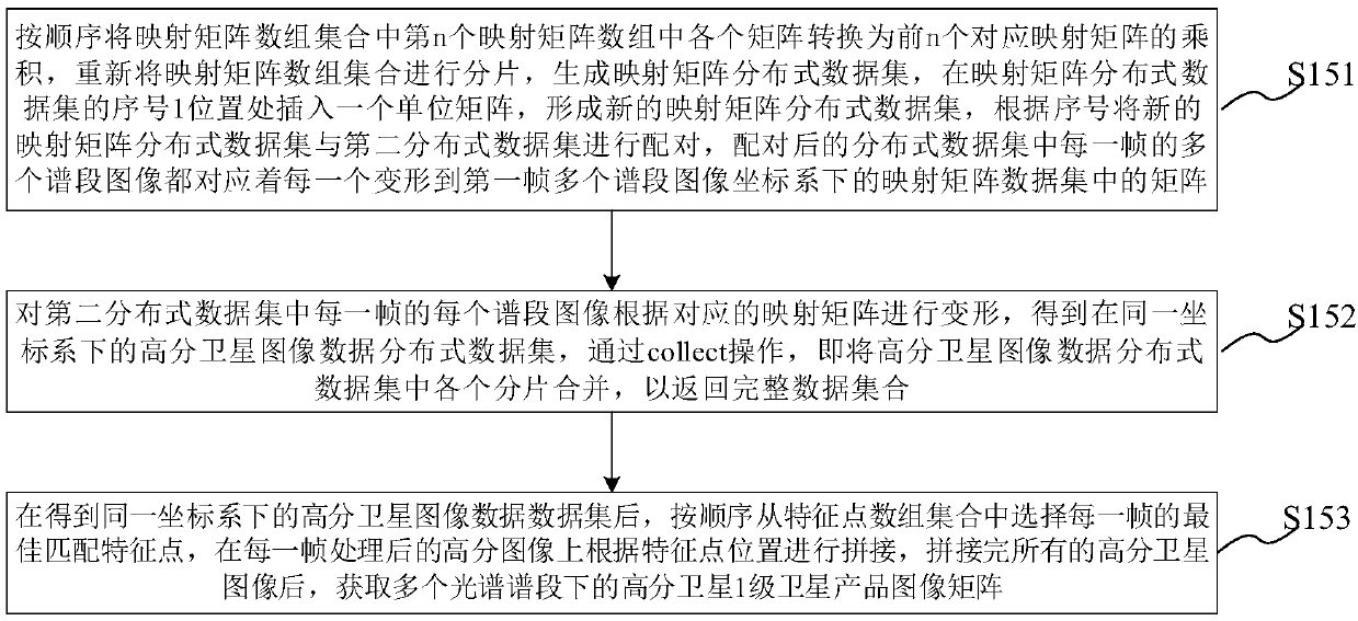
[0033] According to the user's demand for high-resolution satellite remote sensing data, retrieve the index of high-resolution satellite remote sensing data that meets the demand, convert th...

Embodiment 2

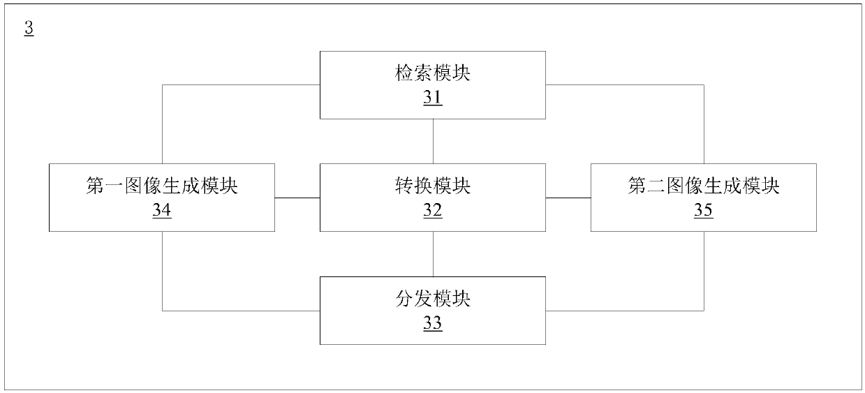
[0062] This embodiment provides a distributed processing system for high-resolution satellite remote sensing data. Before running the processing system, the client obtains the requirements of high-resolution satellite remote sensing data and product parameters of image products selected by the user, and creates a distributed The data processing task is to submit to the satellite data processing and product production platform to process high-resolution satellite remote sensing data; the satellite data processing and product production platform includes a background and a distributed computing platform that is connected to the background and includes multiple computing nodes The distributed processing system of the high-resolution satellite remote sensing data comprises:

[0063] The retrieval module is used to retrieve the index of high-resolution satellite remote sensing data that meets the requirements according to the user's requirements for high-resolution satellite remote ...


PUM


Abstract

The invention provides a distributed processing method / system for high-resolution satellite remote sensing data and a medium, and the method comprises the steps: retrieving the index of the high-resolution satellite remote sensing data, converting the index into a corresponding first distributed data set, and distributing the first distributed data set to each computing node; If the satellite product is a 0-level satellite product, generating an image corresponding to the 0-level product; If the high-resolution satellite remote sensing data is a first-level satellite product, analyzing the high-resolution satellite remote sensing data, converting the high-resolution satellite remote sensing data into a second distributed data set with a serial number, and adding 1 to the serial number of the second distributed data set to form a third distributed data set; Combining the second distributed data set and the third distributed data set, and re-fragmenting and re-distributing the combined distributed data set; And performing an operation of calculating an image mapping matrix on the distributed data set to generate an image corresponding to the first-level satellite product. According to the method, the data processing speed and the product production speed are greatly increased, the hard disk data reading and writing time is shortened, and calculation processing can be rapidly completed.

Description

technical field [0001] The invention belongs to the technical field of satellite communication, and relates to a processing method and system, in particular to a distributed processing method / system and medium for high-resolution satellite remote sensing data. Background technique [0002] With the improvement of satellite technology in recent years, the data volume of satellite data has been continuously increased, reaching TB level or even PB level, and customers have put forward higher requirements in terms of accuracy, ease of use, and rapid response to the query and use of satellite products. This means that the traditional, small-scale, low-level automation, and serial satellite data processing methods are difficult to meet the needs of customers with large data volume, complex processing, and timely satellite remote sensing images and products. In the existing production methods of high-resolution satellite remote sensing products, most of them are small-scale product...

Claims


Application Information

Patent Timeline
IPC IPC(8): G06F16/51G06T3/40H04L29/08
CPCH04L67/10G06T3/4038
Inventor 王茂华袁帅
Owner SHANGHAI ADVANCED RES INST CHINESE ACADEMY OF SCI
Learn More