Method for sharing frontier defense management and control element service information to spatial data

A technology of spatial data and business information, applied in geographic information database, electronic digital data processing, structured data retrieval, etc., can solve the problem of low efficiency, reduce business volume and avoid network congestion.

Pending Publication Date: 2019-04-19
新疆蓝海远大智能科技股份有限公司
View PDF4 Cites 2 Cited by
  • Summary
  • Abstract
  • Description
  • Claims
  • Application Information

AI Technical Summary

Problems solved by technology

However, business information of thematic elements such as front-end equipment (such as real-time video information, real-time radar sector information) cannot be shared with spatial data, and users at each level need to rely on system equipment to obtain relevant business information to superimpose with GIS spatial information. low efficiency

Method used


Image

  • Method for sharing frontier defense management and control element service information to spatial data
  • Method for sharing frontier defense management and control element service information to spatial data

Examples


Embodiment Construction

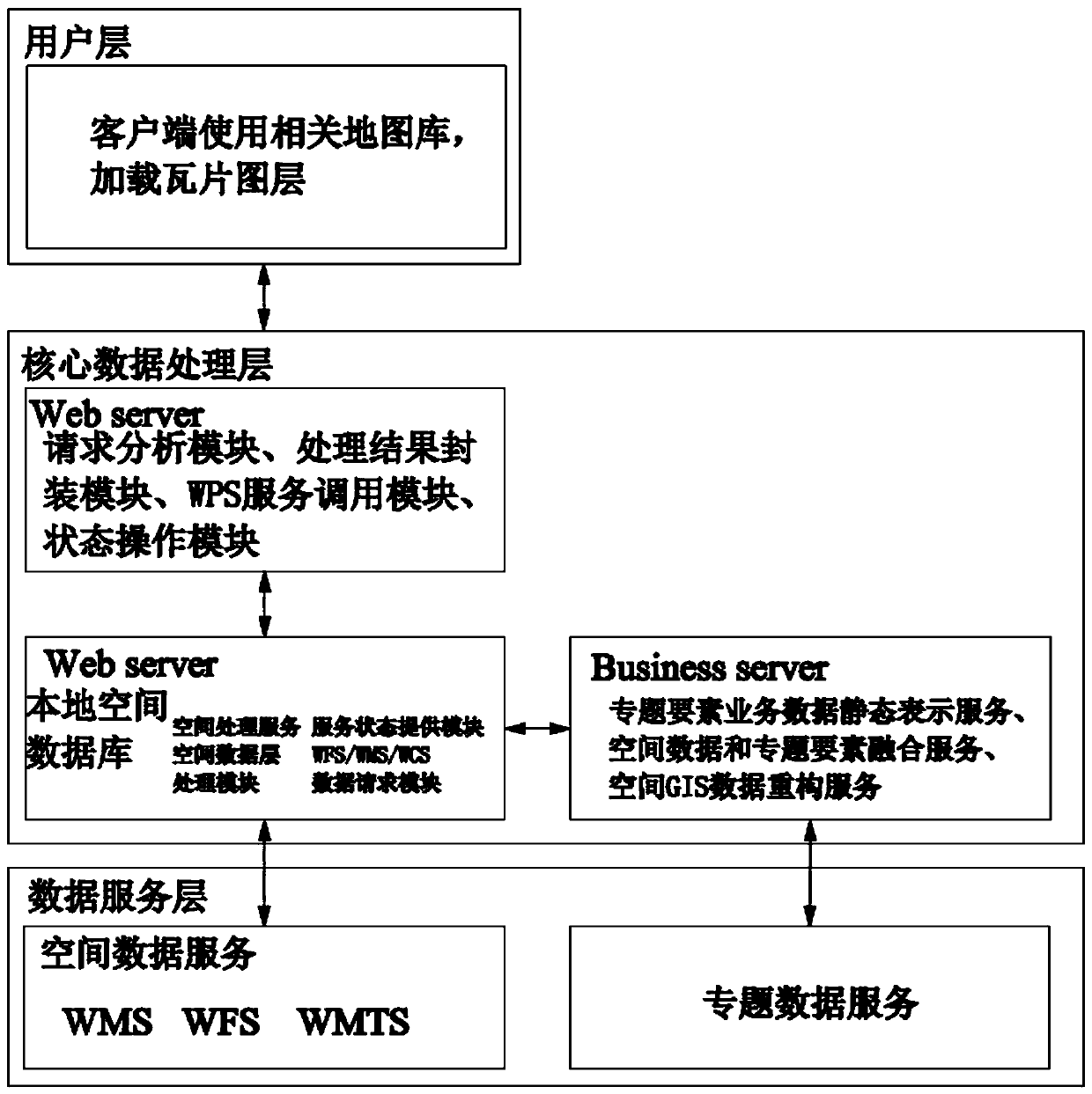
[0029] The present invention will be further described below in conjunction with the accompanying drawings. It should be noted that the following examples are based on the premise of this technical solution, and provide detailed implementation and specific operation process, but the protection scope of the present invention is not limited to the present invention. Example.

[0030] A method for sharing border control element business information to spatial data, the method for sharing border control element business information to spatial data is based on a GIS system, such as figure 1 shown, including the following steps:

[0031] The S1 client uses the specified map library to load the tile layer;

[0032] The S2 command is uploaded to the network server through the request analysis module, processing result encapsulation module, WPS service call module and status operation module of the core data processing layer;

[0033] S3 obtains preliminary processing results from th...


PUM


Abstract

The invention discloses a method for sharing frontier defense control element service information to spatial data, which is based on a GIS (Geographic Information System) and comprises the following steps that: a client loads a tile layer by using an appointed map library; The instruction is uploaded to a network server through a request analysis module, a processing result packaging module, a WPSservice calling module and a state operation module of a core data processing layer; After comparison of a local spatial database in the WPS server, a spatial processing service is completed throughthe spatial data layer processing module, and a special data service on the business server is completed through the WFS or WMS or WCS data request module and the service state providing module. The invention provides a method for sharing service information of special factors such as front-end equipment into spatial data, different GIS platforms do not need to perform corresponding system equipment interface protocol development, and the service information of the special factors of the front-end equipment can be separated from the front-end equipment and can be distributed to the different GIS platforms for use along with the shared spatial data information.

Description

technical field [0001] The invention relates to the technical field of border defense management and control, and specifically designs a method for sharing business information of frontier defense management and control elements to spatial data. Background technique [0002] With the advancement of three-dimensional border construction, video surveillance systems, radar early warning systems, and Beidou positioning systems have been built. However, there are many types of software platforms. The coupling between the systems is very high, and the ability to share and collaborate is lacking, forming an information island. With the increase in the number and types of new equipment, the data flow of each link in the border control system becomes more and more complicated, and the system lacks flexibility. and scalability. Therefore, there is an urgent need for a set of border three-dimensional display system based on spatial information, and part or all of the business inform...

Claims


Application Information

Patent Timeline
IPC IPC(8): G06F16/29G06F17/27G06T11/60
CPCG06T11/60G06F40/295
Inventor 郑建明王健王江
Owner 新疆蓝海远大智能科技股份有限公司
Why Eureka
Try Eureka