
A method and device for identifying effective cultivated land, storage medium and processor

A technology of cultivated land and area, applied in the field of cultivated land identification, can solve the problems of low identification accuracy, achieve high work efficiency, avoid human analysis and judgment, and achieve the effect of small data volume

Active Publication Date: 2021-04-20
SHENZHEN INST OF ADVANCED TECH CHINESE ACAD OF SCI
View PDF10 Cites 0 Cited by
  • Summary
  • Abstract
  • Description
  • Claims
  • Application Information

AI Technical Summary

Problems solved by technology

[0005] Embodiments of the present invention provide a method and device for identifying effective cultivated land, so as to at least solve the technical problem of low identification accuracy of existing agricultural cultivated land crop identification methods

Method used


Image

  • A method and device for identifying effective cultivated land, storage medium and processor
  • A method and device for identifying effective cultivated land, storage medium and processor
  • A method and device for identifying effective cultivated land, storage medium and processor

Examples


Embodiment 1

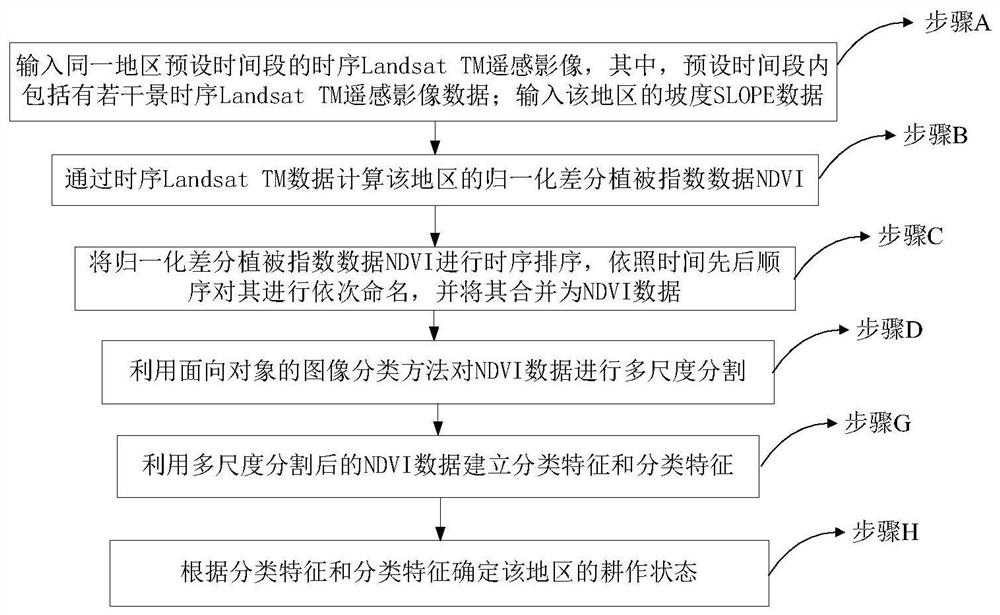
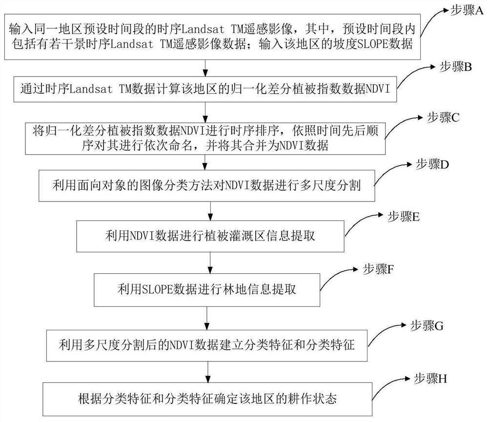
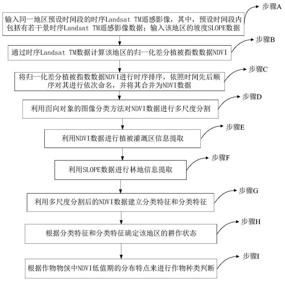
[0083] According to an embodiment of the present invention, a method for identifying effective cultivated land is provided, see figure 1 , including the following steps:

[0084] A. Input the time-series Landsat TM remote sensing images of the same area for a preset time period, wherein, the preset time period includes several time-series Landsat TM remote sensing image data; input the slope SLOPE data of the area;

[0085] B. Calculate the normalized difference vegetation index data NDVI of this area through the time series Landsat TM data;

[0086] C. Sorting the normalized difference vegetation index data NDVI in time series, and named it NDVI according to the order of time 1 、NDVI 2 、NDVI 3 ,...,NDVI n , where NDVI n It is the nth normalized difference vegetation index data NDVI, n is an integer ≥ 1, and it is merged into NDVI data;

[0087] D. Using an object-oriented image classification method to perform multi-scale segmentation of NDVI data;

[0088] G. Using mu...

Embodiment 2

[0147] According to an embodiment of the present invention, a storage medium is provided, and the storage medium stores a program file capable of implementing any one of the above methods for identifying effective cultivated land.

Embodiment 3

[0149] According to an embodiment of the present invention, a processor is provided, and the processor is used to run a program, wherein, when the program is running, any method for identifying effective cultivated land as described above is executed.


PUM


Abstract

The present invention relates to the field of cultivated land identification, in particular to a method and device for identifying effective cultivated land. The method and device use long-time sequence Landsat TM remote sensing data as a data source, use slope SLOPE data as auxiliary data, and use normalized differential vegetation The index NDVI is used as a classification feature, based on the phenological differences of crops on agricultural land, and reflects the differences in planting period, spectral difference and other characteristics of crop species to the distribution of time-series NDVI data, and designs a normalized difference The object-oriented decision-making classification rules combined with vegetation index NDVI and other classification features can not only extract the spatial distribution information of some crops on agricultural land, especially in West Asia, but also understand their cultivation conditions without considering the complex vegetation of different crops. However, the data source required by this method is easier to obtain, the amount of data to be processed is small, the classification rules are simple, and the work efficiency is high. It is also applicable to areas where the distribution of cultivated land is relatively fragmented.

Description

technical field [0001] The present invention relates to the field of cultivated land identification, in particular to a method and device for identifying effective cultivated land, a storage medium and a processor. Background technique [0002] It is generally believed that the NDVI time-series data of crops have a good correlation with their morphological characteristics, biochemical parameters and phenological information. Using NDVI time-series data can obtain crop category information on arable land. Therefore, multi-temporal time-series remote sensing image data is used for target crop Information identification is one of the most commonly used methods at present. However, due to the uneven distribution of crop phenology information in each time period, it is customary to use the best time-phase combination of crops for crop identification, which mainly uses the intermediate difference between crop spectrum and phenological information. [0003] At present, there are n...

Claims


Application Information

Patent Timeline
Patent Type & Authority Patents(China)
IPC IPC(8): G06K9/00G06K9/34G06K9/62
CPCG06V20/188G06V10/267G06F18/24
Inventor 韩宇李洪忠陈劲松姜小砾
Owner SHENZHEN INST OF ADVANCED TECH CHINESE ACAD OF SCI
Learn More