A method and system for calibrating an accelerometer using a satellite tracking satellite device

A technology for satellite tracking satellites and accelerometers, applied in the field of geodetic surveying, can solve problems such as inability to reach the level of accuracy and poor calibration effect, and achieve the effect of avoiding terrain constraints

Active Publication Date: 2020-05-01
湖北省地震局
View PDF4 Cites 0 Cited by
  • Summary
  • Abstract
  • Description
  • Claims
  • Application Information

AI Technical Summary

Problems solved by technology

However, this method has very high requirements for the selection of inspection areas. In practical applications, it is found that the calibration effect is the best in areas with gentle terrain fluctuations and dense data collection; the calibration effect is poor in areas with large terrain fluctuations and sparse data collection, which cannot meet the accuracy level requirements.

Method used


Image

  • A method and system for calibrating an accelerometer using a satellite tracking satellite device
  • A method and system for calibrating an accelerometer using a satellite tracking satellite device
  • A method and system for calibrating an accelerometer using a satellite tracking satellite device

Examples


Embodiment Construction

[0043]In order to make the object, technical solution and advantages of the present invention clearer, the present invention will be further described in detail below in combination with specific embodiments and with reference to the accompanying drawings. It should be understood that these descriptions are exemplary only, and are not intended to limit the scope of the present invention. Also, in the following description, descriptions of well-known structures and techniques are omitted to avoid unnecessarily obscuring the concept of the present invention.

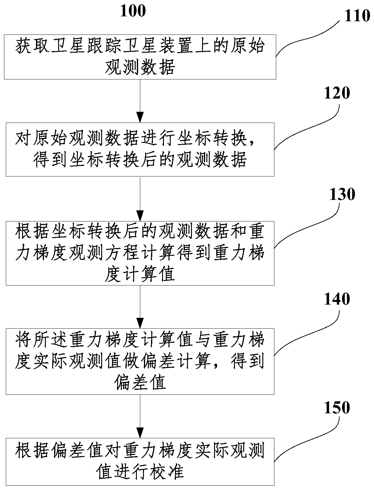
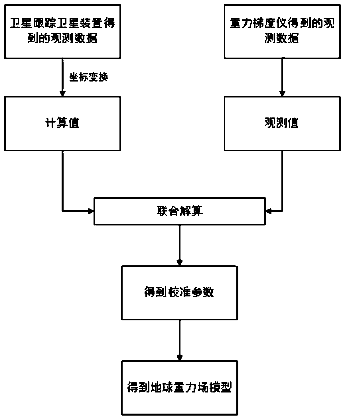
[0044] The calibration of the observed value of the gravity gradient refers to the comparison of the calculated value calculated by various methods with the actual observed data of the gravity gradient to obtain the deviation value, and the analysis of the deviation value can calibrate the observed value of the gravity gradient. The accuracy of the gravity gradient data is closely related to the calculated values ​​obtaine...


PUM


Abstract

The invention discloses a method and system for calibrating an accelerometer using a satellite-to-satellite tracking device. The method comprises the steps that original observation data on the satellite-to-satellite tracking device is acquired; coordinate transformation is performed on the original observation data to obtain observation data after the coordinate transformation; a gravity gradientcalculated value is calculated and obtained according to the observation data after the coordinate transformation and a gravity gradient observation equation; deviation calculation is performed on the gravity gradient calculated value and an actual gravity gradient observation value to obtain a deviation value; and the actual gravity gradient observation value is calibrated according to the deviation value. The method and system adopt the satellite-to-satellite tracking device to acquire the observation value, and calculate and obtain the gravity gradient calculated value, thereby effectivelysolving the problem that data generated simply by a gravity field model cannot meet better precision requirements, solving the problems such as terrain constraints, and achieving the purpose of high-precision calibration of the gravity accelerometer.

Description

technical field [0001] The invention relates to the field of geodesy, in particular to a method and system for calibrating an accelerometer by using a satellite tracking satellite device. Background technique [0002] At present, the satellite gravity gradient platform developed at home and abroad is mainly the GOCE gravity gradient measurement satellite mission launched by the European Space Agency and the civilian gravity gradient measurement satellite technology system being developed in my country. The GOCE satellite launched by the European Space Agency is equipped with multiple types of payloads, including three-axis orthogonal gravity gradiometer (EGG), laser retroreflector (LRR), high-precision dual-frequency GNSS receiver, satellite tracking device, attitude control system, Planetarium and ion thrusters. Among them, the gravity gradiometer and satellite tracking device are the key loads of the GOCE satellite technology system. [0003] The original observation dat...

Claims


Application Information

Patent Timeline
Patent Type & Authority Patents(China)
IPC IPC(8): G01V7/00G01V13/00
CPCG01V7/00G01V13/00
Inventor 吴云龙邹正波张毅胡敏章李查玮
Owner 湖北省地震局
Why Eureka
Try Eureka