A method and device for evaluating wind resources in complex terrain
A technology for complex terrain and wind resources, applied in the field of complex terrain wind resource assessment methods and devices, can solve the problems of different applicability, limited computing resources, inaccurate assessment and prediction results, etc., and achieve the goal of reducing uncertainty and forecasting accuracy Improve the effect of help, improve simulation ability
- Summary
- Abstract
- Description
- Claims
- Application Information
AI Technical Summary
Problems solved by technology
Method used
Image
Examples
Embodiment 1
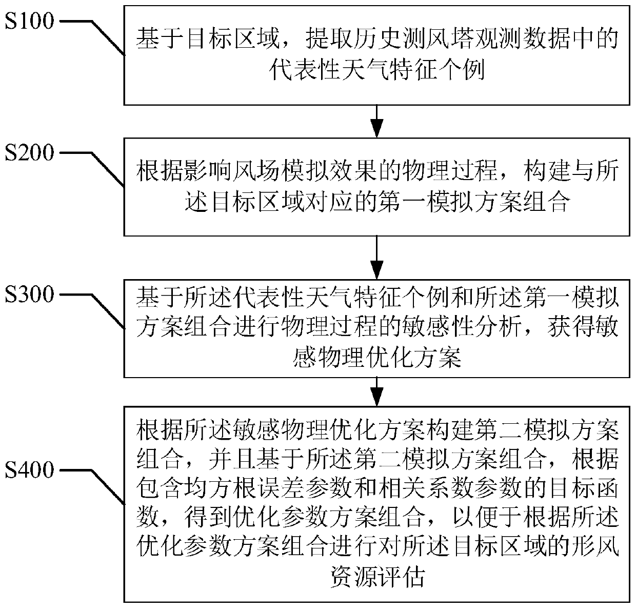
[0057] refer to figure 2 , the first embodiment of the present invention provides a method for evaluating wind resources in complex terrain, including:
[0058] Step S100, based on the target area, extract representative cases of weather characteristics in the historical wind tower observation data;
[0059] As mentioned above, it needs to be explained that the wind measuring tower is a towering tower structure used for measuring wind energy parameters, that is, a tower-shaped structure used for observing and recording the movement of airflow near the surface. In the past, most of them were built by wind power enterprises, meteorological and environmental protection departments, and were used for meteorological observation and atmospheric environment monitoring.
[0060] As mentioned above, the target area may be an area specific to a specific terrain in a specific area.
[0061] Above, the observation data of historical wind measuring towers are the observation data of exi...
Embodiment 2
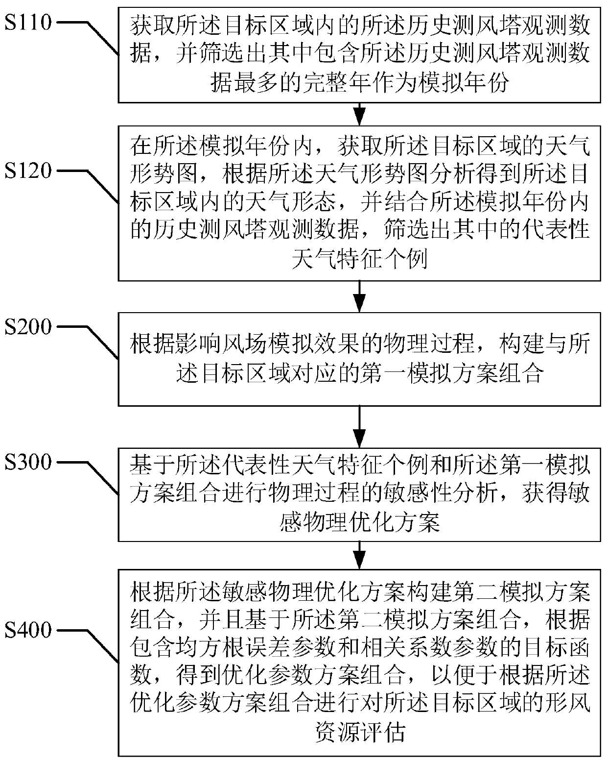
[0069] refer to image 3 , the second embodiment of the present invention provides a method for evaluating wind resources in complex terrain, based on the above figure 2 In the first embodiment shown, the step S100, "based on the target area, extracting a representative example of weather characteristics in the historical wind tower observation data" includes:
[0070] Step S110, obtaining the observation data of the historical wind measuring tower in the target area, and selecting the complete year containing the most observation data of the historical wind measuring tower as the simulation year;
[0071] Step S120, in the simulation year, obtain the weather situation map of the target area, analyze the weather pattern in the target area according to the weather situation map, and combine the observations of the historical wind measuring towers in the simulation year Data, and select representative cases of weather characteristics.
[0072] As mentioned above, when extract...
Embodiment 3
[0076] refer to Figure 4 , the third embodiment of the present invention provides a complex terrain wind resource assessment method, based on the above image 3 In the second embodiment shown, wherein, the physical processes affecting the wind field simulation effect include microphysical processes, radiation processes, land surface processes, boundary layers and cumulus convection;
[0077] The step S200, "construct the first simulation scheme combination corresponding to the target area according to the physical process affecting the wind field simulation effect" includes:
[0078] Step S210, for the microphysical process, the radiation process, the land surface process, the boundary layer and the cumulus convection, screen out a parameterization scheme corresponding to the target area in each physical process;
[0079] Step S220, according to the parameterization schemes screened out, each of the parameterization schemes in each of the physical processes is combined with ...
PUM
 Abstract
Description
Claims
Application Information
 - R&D
- Intellectual Property
- Life Sciences
- Materials
- Tech Scout
- Unparalleled Data Quality
- Higher Quality Content
- 60% Fewer Hallucinations
Browse by: Latest US Patents, China's latest patents, Technical Efficacy Thesaurus, Application Domain, Technology Topic, Popular Technical Reports.
© 2025 PatSnap. All rights reserved.Legal|Privacy policy|Modern Slavery Act Transparency Statement|Sitemap|About US| Contact US: help@patsnap.com


