A method and system for site modeling based on BIM model and aerial photography technology

A modeling method and model technology, applied in 3D modeling, image data processing, resources, etc., can solve the problems of poor versatility, inability to realize informatization and intelligence of engineering construction, and achieve easy layout and targeted Effect

Active Publication Date: 2019-03-15
GUANGXI ROAD & BRIDGE ENG GRP CO LTD
View PDF5 Cites 13 Cited by
  • Summary
  • Abstract
  • Description
  • Claims
  • Application Information

AI Technical Summary

Problems solved by technology

[0004] The technical problem to be solved by the present invention is to provide a construction site modeling method based on BIM model and aerial photography technology. This modeling method can solve the problem that the traditional modeling method has poor versatility and cannot realize the informatization and intelligence of engineering construction. technical issues

Method used


Image

  • A method and system for site modeling based on BIM model and aerial photography technology
  • A method and system for site modeling based on BIM model and aerial photography technology
  • A method and system for site modeling based on BIM model and aerial photography technology

Examples


Embodiment Construction

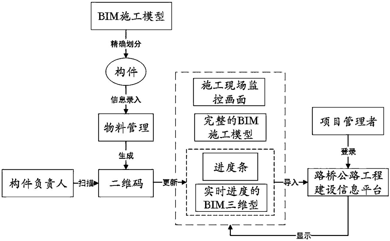
[0043] Such as figure 1 As shown, a construction site modeling method based on BIM model and aerial photography technology includes the following steps:

[0044] 1. Use UAV aerial photography technology to obtain topographic pictures of the construction site. The basic technical route is: set the basic parameters of UAV aerial photography (including navigation route, horizontal and vertical photo overlap rate, flight height, lens inclination, etc.) - construction site Control drones to collect on-site terrain data.

[0045] 2. Import the actual topographic map recorded with the geographical information data of the construction site collected by the drone into the Smart3D three-dimensional modeling software, perform aerial three-encryption calculations to generate point cloud data, and use the point cloud data to make a construction site. The 3D simulation model of the actual topographic map; import the topographic pictures collected by the UAV into Smart3D software, perform a...


PUM


Abstract

The invention provides a site modeling method and system based on BIM model and aerial photography technology. The method comprises the following steps: 1) acquiring geographic information data of thesite by aerial photography equipment; 2) importing the actual topographic picture of the construction site into the three-dimensional modeling software to make the three-dimensional simulation modelof the actual topographic map of the construction site; 3) Establishing BIM model of site environment by using modeling software; 4) analyze, converting and lighten that BIM model into the three-dimensional simulation model obtained in the step 2), and combining the BIM model with the three-dimensional simulation model on the site to form an open source system; 5) integrating the open source system and the business system obtained in the step 4) into an information management platform of engineering construction for managers to log in. The modeling method can solve the technical problems thatthe traditional modeling method has poor generality and can not realize the informationization and intelligence of engineering construction.

Description

technical field [0001] The present invention relates to the technical field of digital modeling, in particular to a construction site modeling method and system based on BIM model and aerial photography technology. Background technique [0002] The full English name of Building Information Modeling (BIM) is Building Information Modeling, which is a complete information model that can integrate engineering information, processes and resources in different stages of the project's life cycle into one model, which can be easily used by Used by all parties involved in the project. Through the three-dimensional digital technology to simulate the real information of the building, it provides a coordinated and internally consistent information model for engineering design and construction, so that the model can achieve the integration of design and construction, and all disciplines can work together, thereby reducing engineering production costs. Ensure that projects are completed ...

Claims


Application Information

Patent Timeline
Patent Type & Authority Applications(China)
IPC IPC(8): G06Q10/06G06Q50/08G06F17/50G06T17/05G06T17/20
CPCG06Q10/063114G06Q10/06313G06Q50/08G06T17/05G06T17/20G06F30/13
Inventor 王建军陈孝强林广泰孙辉郑健王渝清班贵生曾明智梁承斌许宗勇李雍友吕开明
Owner GUANGXI ROAD & BRIDGE ENG GRP CO LTD
Why Eureka
Try Eureka