
Improved interactive voting matching method for low-frequency GPS trajectory

A matching method and interactive technology, applied in the field of map matching, can solve the problem that the map matching algorithm cannot take into account matching accuracy and efficiency, and achieve the effect of improving matching accuracy, high efficiency, and high matching accuracy

Active Publication Date: 2019-03-12
HANGZHOU DIANZI UNIV
View PDF5 Cites 11 Cited by
  • Summary
  • Abstract
  • Description
  • Claims
  • Application Information

AI Technical Summary

Problems solved by technology

[0004] Aiming at the problem that the existing map matching algorithm cannot take into account the matching accuracy and efficiency, the present invention proposes an improved interactive voting matching method for low-frequency GPS trajectories

Method used


Image

  • Improved interactive voting matching method for low-frequency GPS trajectory
  • Improved interactive voting matching method for low-frequency GPS trajectory
  • Improved interactive voting matching method for low-frequency GPS trajectory

Examples


Embodiment Construction

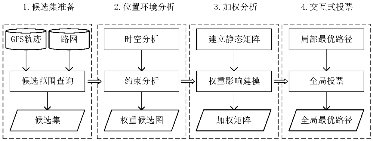
[0022] The system structure of the present invention is as figure 1 shown. It consists of the following parts: candidate point preparation, location context analysis, weighting analysis and interactive voting.

[0023] 1. Candidate point preparation

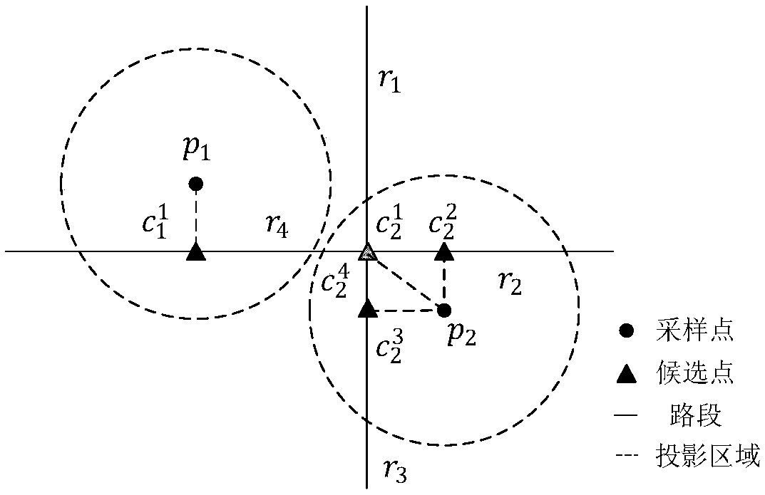
[0024] For GPS track P=(p i |i=1,2,3...N), select all the road sections within the radius r in the road network with the GPS point as the center as the candidate road sections k means GPS point p i The kth candidate road segment of , select the point closest to the GPS point on the road segment as the candidate point. Such as figure 2 As shown, the GPS point p 1 has a candidate road segment r 3 , corresponding to a candidate point GPS point p 2 There are four candidate road segments, road segment r 2 and r 3 corresponding candidate points and falls within the range of the road segment, and the road segment r 1 and r 4 corresponding candidate points and It falls on the starting node corresponding to the roa...


PUM


Abstract

The invention discloses an improved interactive voting map route matching method for a low-frequency GPS trajectory, which not only considers a distance feature, a topologic structure of a road and alimit speed of a road section, but also considers a real-time moving direction and speed of each GPS point, so that the matching accuracy can be improved; in addition, a filter is added, a candidate noise road section is removed by virtue of a constraint condition, so that the matching efficiency is improved. The improved interactive voting matching method for the low-frequency GPS trajectory hasthe advantages of high matching accuracy, high efficiency and high robustness.

Description

technical field [0001] The invention belongs to the technical field of map matching in intelligent transportation, relates to a map matching algorithm, and specifically relates to a method for processing low-frequency GPS tracks. Background technique [0002] With the popularity of electronic mobile devices with built-in GPS sensors, a large number of driving trajectories are generated every day. However, due to the limitations of satellite positioning systems, especially in urbanized areas with limited satellite visibility and high-rise buildings, satellite signals are blocked and refracted, resulting in inaccurate and lost positioning data. Therefore, the positioning data we collect through electronic devices is inaccurate. In addition, due to the limitations of device power, storage, and network transmission bandwidth, most of the trajectory data actually collected are of low sampling rate (for example: the sampling interval is 1 minute or more). A mobile object carryin...

Claims


Application Information

Patent Timeline
IPC IPC(8): G01C21/32
CPCG01C21/32
Inventor 周后盘严盛隆于娟
Owner HANGZHOU DIANZI UNIV
Learn More