Bidirectional interaction system for assisted total station measurement and rapid mapping

A total station, fast technology, applied in the direction of measuring devices, measuring instruments, surveying and navigation, etc., can solve the problems of weight measurement, poor communication, unintelligent, etc., and achieve the effect of improving surveying and mapping efficiency and reducing missed surveys

Inactive Publication Date: 2019-02-15
淮安市水利勘测设计研究院有限公司
View PDF7 Cites 3 Cited by
  • Summary
  • Abstract
  • Description
  • Claims
  • Application Information

AI Technical Summary

Problems solved by technology

[0003] Now the process of using the total station to measure points is to end with "obtaining its position information after aiming at the prism", which can be regarded as a one-way "communication" between the total station and the prism, that is, "the total station can obtain the position of the prism coordinate information, but the prism operator cannot obtain the generated coordinate information in time”, which will cause inconvenience to field measurement and internal page mapping
[0004] At the same time, due to the small and unintelligent input keyboard of the total station, and the poor communication between the total station and the prism operator, it is extremely inconvenient to record point attributes, which can only be done by drawing sketches and manually recording point attributes. Attributes are retained; in addition, each total station needs to observe multiple prisms at the same time, and the communication between the prism operators is also poor, so the prism operators do not have an intuitive grasp of all the measured points, which may lead to missing measurements or weighing
These two disadvantages of the total station application will increase the extra workload in the field, and at the same time increase the difficulty of drawing the inner pages

Method used


Image

  • Bidirectional interaction system for assisted total station measurement and rapid mapping
  • Bidirectional interaction system for assisted total station measurement and rapid mapping
  • Bidirectional interaction system for assisted total station measurement and rapid mapping

Examples


Embodiment Construction

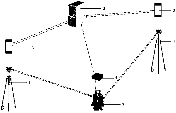
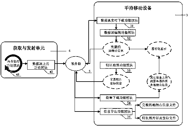
[0028] see figure 1 , is a schematic diagram of the surveying and mapping operation application structure of the two-way interactive system for auxiliary total station measurement and rapid mapping provided by the present invention, including prism 1 (including prism 1A, prism 1B), total station 2, and handheld mobile device 3 (including handheld Mobile device 3A, handheld mobile device 3B), acquisition and sending unit 4; the total station 2 is erected on the control point, and the prism 1A and prism 1B are respectively erected on any two fragmentary points, the acquisition and The sending unit 4 is connected with the total station 2 through a serial port line, and the handheld mobile device is used as a set with the prism, the handheld mobile device 3A is matched with the prism 1A, and the handheld mobile device 3B is matched with the prism 3B.

[0029] The prism 1 is a general reflective prism, and the total station 2 needs to be able to exchange data between internal progr...


PUM


Abstract

The invention discloses a bidirectional interaction system for assisted total station measurement and rapid mapping. The bidirectional interaction system comprises an acquisition and transmission unitand handheld mobile equipment, wherein the acquisition and transmission unit is connected with a total station; the handheld mobile equipment is simultaneously used by prism operators; the acquisition and transmission unit is capable of monitoring memory change of the total station in real time and uploading new data streams in the memory to a server by utilizing a network; and the handheld mobile equipment is capable of downloading the data streams from the server in real time for editing and graphical displaying, uploading the completed planimetric point information to the server, shootingreal photos of feature ground objects, downloading planimetric point information uploaded to the server by other handheld mobile equipment in batches and exporting standard file formats. With the adoption of the technical scheme, bidirectional 'communication' between the total station and prisms can be realized, and by virtue of cooperation of the prisms, the coordinate and attribute information of the ground objects can be synchronously acquired, the operating manners of sketching, manual attribute recording and the like can be effectively avoided, the prism operators have intuitive feeling on measured objects, the possibility of missing measure and weight sensing is reduced, the field operation surveying and mapping efficiency can be effectively improved, great convenience is brought toinside page mapping, and the bidirectional interaction system can be widely applied to occasions with severe sheltering conditions such as city engineering survey, river ground object survey and the like.

Description

technical field [0001] The invention relates to the technical field of engineering surveying, in particular to a two-way interactive system for assisting total station surveying and rapid mapping. Background technique [0002] At present, GNSS RTK technology has been widely used in the field of engineering surveying. It has the advantages of easy editing and clear point attributes, and fast measurement speed. , the measurement speed will be greatly reduced, and the accuracy will also be reduced to a certain extent, then a total station will be used for measurement. Under the premise that the accuracy of the control points meets the requirements, the accuracy of the results of the total station can be guaranteed. [0003] Now the process of using the total station to measure points is to end with "obtaining its position information after aiming at the prism", which can be regarded as a one-way "communication" between the total station and the prism, that is, "the total stati...

Claims


Application Information

Patent Timeline
Patent Type & Authority Applications(China)
IPC IPC(8): G01C15/00G06F16/29G06F16/904
CPCG01C15/00
Inventor 李磊丁旭东李亮王胜王建张明王丞沈正波丁中原顾利红张宁宁郑舒阳
Owner 淮安市水利勘测设计研究院有限公司
Why Eureka
Try Eureka