Space multi-robot autonomous navigation method oriented to geostationary orbit target operation

A technology of geostationary orbit and target operation, applied in the direction of integrated navigator, etc., can solve the problem of low navigation accuracy

Inactive Publication Date: 2019-01-25
SOUTHEAST UNIV
View PDF1 Cites 2 Cited by
  • Summary
  • Abstract
  • Description
  • Claims
  • Application Information

AI Technical Summary

Problems solved by technology

[0005] Purpose of the invention: The present invention aims at the problem of low navigation accuracy due to insufficient observation information, and proposes a space multi-robot autonomous navigation method for geostationary orbit target operations, using a star sensor to autonomously and continuously observe the relative direction vector. Orbital service space multi-robots provide high-precision relative observation information

Method used


Image

  • Space multi-robot autonomous navigation method oriented to geostationary orbit target operation
  • Space multi-robot autonomous navigation method oriented to geostationary orbit target operation
  • Space multi-robot autonomous navigation method oriented to geostationary orbit target operation

Examples


Embodiment Construction

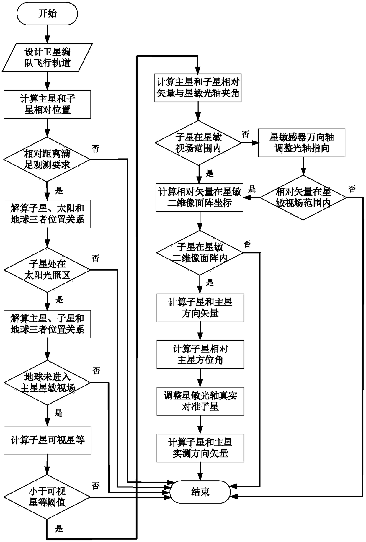
[0097] The technical solution of the present invention will be further introduced below in combination with specific implementation methods and accompanying drawings.

[0098] This specific embodiment discloses a space multi-robot autonomous navigation method for geostationary orbit target operation, such as figure 1 and figure 2 shown, including the following steps:

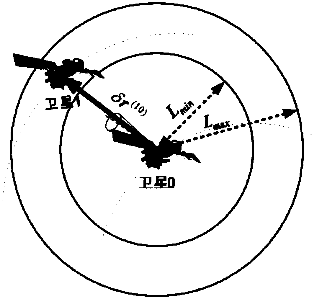
[0099] S1: Taking the GEO target satellite as the in-orbit service object, set the two space robots as the main star and the sub-star respectively, and design the formation flight configuration and orbit parameters of the main star and the sub-star; the orbit parameters include the orbital semi-major axis a, orbital eccentricity e, Orbital inclination i, right ascension of ascending node Ω, argument of perigee ω, perigee time t p ;

[0100] S2: According to the relative orbital dynamics model of the satellite in the earth-centered inertial coordinate system, establish the state model of the autonomous naviga...


PUM


Abstract

The invention provides a space multi-robot autonomous navigation method oriented to geostationary orbit target operation, and aims to provide high-accuracy location and velocity information for satellite formation flight and effectively solve the problem of lower navigation accuracy caused by insufficient observation information for the satellite formation flight. A satellite sensor is a celestialbody sensor for observing a fixed satellite, and a specific condition needs to be met when inter-satellite relative measurement is performed by using the satellite sensor. By adopting the method, light conditions required by inter-satellite observation and an observing condition of the satellite sensor are provided, so that the problem that the conventional satellite sensor can only be observed passively is solved, and the autonomous satellite selection accuracy is improved. On the basis of realizing inter-satellite observation, a method for calculating the orientation vector, orientation angle and pitch angle of a main satellite relative to a component in real time is provided. Moreover, the pointing direction of the satellite sensor is adjusted by using a universal shaft for continuously tracking the component, so that the problem of failure in continuous tracking existing in the conventional observation is solved, and the inter-satellite continuous observation efficiency is improved.

Description

technical field [0001] The invention relates to the field of spacecraft on-orbit service space measurement, in particular to an autonomous navigation method for space multi-robots operating in the face of geostationary orbit targets. Background technique [0002] Geostationary orbit (Geostationary orbit, GEO) is a unique orbital resource for human beings. Satellites in this orbit (GEO satellites for short) cover a large area and are stationary relative to the ground. The military field is playing an increasingly important role. For some tasks, multiple satellites need to be networked to form a constellation, such as the US DSP (Defense Support Program) missile early warning satellite, which always maintains 5 (3 working, 2 spare) satellites in GEO orbit; The high-orbit segment of the Space-Based Infrared System (SBIRS) also includes 4 GEO satellites and 2 large elliptical orbit satellites. The Beidou system under construction is a global satellite navigation system indepen...

Claims


Application Information

Patent Timeline
IPC IPC(8): G01C21/24
CPCG01C21/24
Inventor 王鹏
Owner SOUTHEAST UNIV
Why Eureka
Try Eureka