
Seabed sulfide ore prospecting method based on topographic analysis

A technology of terrain analysis and sulfide, applied in geophysical measurement, instruments, etc., can solve the problems of regular network sampling, etc., and achieve the effects of saving costs and labor costs, short offshore operation time, and good detection results

Active Publication Date: 2019-01-11
SECOND INST OF OCEANOGRAPHY MNR
View PDF4 Cites 9 Cited by
  • Summary
  • Abstract
  • Description
  • Claims
  • Application Information

AI Technical Summary

Problems solved by technology

However, the main problem at present is that it is impossible to achieve the same regular network sampling as on land. Due to the cost, there are few sampling stations for marine sediments. In this case, reasonable and efficient sampling station planning is of great significance. The position setting method puts forward new requirements, especially in the mid-ocean ridge region with complex terrain, there is no corresponding theory to guide, and the use of geochemical and heavy sand mineral methods to delineate mining areas in the mid-ocean ridge region is facing new challenges
From the analysis of retrieved public data, there is currently no mature technical method to guide the setting of sediment sampling stations in seabed sulfide exploration, and to conduct comprehensive exploration in combination with heavy sand minerals and geochemical methods

Method used


Image

  • Seabed sulfide ore prospecting method based on topographic analysis
  • Seabed sulfide ore prospecting method based on topographic analysis
  • Seabed sulfide ore prospecting method based on topographic analysis

Examples


Embodiment Construction

[0046] The following describes the implementation of the present invention in detail through specific examples in conjunction with the accompanying drawings, and those skilled in the art can easily understand the implementation steps, effects and advantages of the present invention according to the description. The present invention can also be applied to other types of prospecting work on the seabed, and technicians can adjust various details according to different application scenarios without departing from the spirit of the present invention, such as the acquisition method of various data, terrain data, etc. accuracy etc. It should be noted that any detailed adjustments made by those skilled in the art within the scope of the claims belong to the protection category of the present invention.

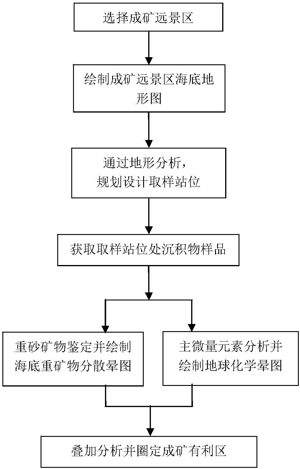
[0047] see figure 1 The process flow diagram, the present invention provides a kind of seabed sulfide prospecting method based on terrain analysis, comprises the following steps:

...


PUM


Abstract

The invention discloses a seabed sulfide ore prospecting method based on topographic analysis, which comprises the following steps: step 1: selecting a mineralizing prospect area; step 2: searching for topographic data of the mineralizing prospect area and drawing a topographic map of the seabed; step 3: analyzing the topographic map of the seabed, and planning and designing a sampling station; step 4: obtaining a sediment sample at the sampling station position in the step 3; step 5: performing heavy sand mineral identification and main trace element analysis on the sediment sample, and drawing a seabed heavy mineral dispersion halo map and a geochemical halo map; step 6: performing overlay analysis on the seabed heavy mineral dispersion halo map and the geochemical halo map, and defininga favorable mineralization area in combination with the topographic analysis. The method in the invention optimizes and innovates the sampling station setting of the seabed sediment, and the samplingstation setting is more reasonable and effective; combined with the heavy mineral and geochemical methods, a better detection effect is achieved for the inactive hydrothermal zone concealed sulfide and secondary enrichment mineralization; and the cost is low compared with other methods.

Description

technical field [0001] The present invention relates to a seabed sulfide ore prospecting method based on terrain analysis guidance, in particular to a seabed sulfide comprehensive prospecting method based on terrain analysis results to design and plan sediment sampling stations, combined with heavy sand minerals and geochemical analysis mine method. Background technique [0002] The 21st century is the century of the ocean. In particular, my country signed the world's first polymetallic sulphide exploration contract with the International Seabed Authority. A series of achievements have been made in sulphide exploration. [0003] In the past decade, the presence of hydrothermal activities was mainly judged by water body anomalies. Equipment such as MAPR turbidity detectors, various water chemical sensors, and grabs are widely used in ocean scientific research, which improves the efficiency of investigations. However, from the perspective of ore prospecting, water anomaly de...

Claims


Application Information

Patent Timeline
IPC IPC(8): G01V9/00
CPCG01V9/00
Inventor 陶春辉潘东雷廖时理邓显明王渊周建平顾春华王汉闯李泽刘露诗
Owner SECOND INST OF OCEANOGRAPHY MNR
Learn More