Vehicle positioning method based on vision, GPS and high-precision map fusion

A technology for GPS positioning and vehicle positioning, applied in the field of safe assisted driving, can solve the problems of low GPS positioning accuracy, cumulative errors in visual positioning, and inability to global positioning, and achieve the effects of strong robustness, high accuracy and low cost.

Active Publication Date: 2018-11-20
HEBEI UNIV OF TECH
View PDF6 Cites 25 Cited by
  • Summary
  • Abstract
  • Description
  • Claims
  • Application Information

AI Technical Summary

Problems solved by technology

The construction of the map in this method solves the problems of lack of map data and wear and tear of road signs in some complex road sections. Fusion positioning overco...

Method used


Image

  • Vehicle positioning method based on vision, GPS and high-precision map fusion
  • Vehicle positioning method based on vision, GPS and high-precision map fusion
  • Vehicle positioning method based on vision, GPS and high-precision map fusion

Examples


Embodiment 1

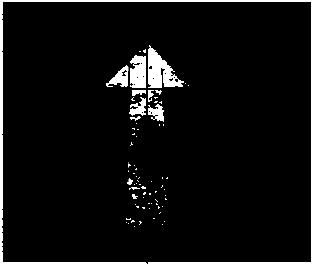
[0088] In this embodiment, Shouqin Road and Xuexi Road of Hebei University of Technology are used as test sites, and the straight arrows of the sites are used as experimental reference objects. All pictures taken by the vehicle-mounted camera system are 640*480 (pixels).

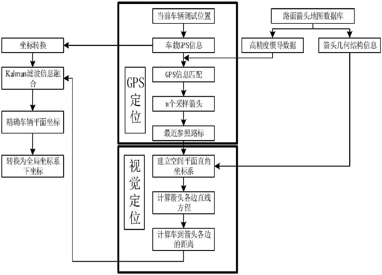
[0089] In this embodiment, the vehicle positioning method based on fusion of vision, GPS and high-precision map includes the following steps:

[0090] The first step is to build a high-precision road arrow map:

[0091] 1-1. Map data collection:

[0092] The vehicle-mounted camera is placed behind the windshield, with a height of 123cm, looking down at an angle of about 30 degrees, and the camera is kept in a fixed position during the experiment. Shoot when there are indicating arrows on the road surface, and at the same time use GPS receiver, integrated inertial navigation system and DGPS base station to collect high-precision inertial navigation data of the arrow, and use measuring tools (tape measure, sq...

Embodiment 2

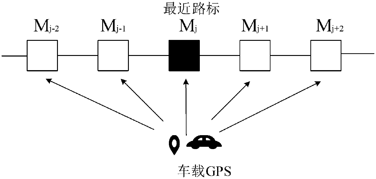
[0119] Select Ziqiang Road, Chengxue Road, and Xuexi Road of Hebei University of Technology as the test site. In addition to straight arrows, it also includes various other types of arrows, such as right turn, left turn, double turn, right turn plus straight, etc., respectively. Other types of arrows are fused and positioned with reference to the nearest landmarks, and 15 sets of positioning experiments are carried out for each type of arrow at different locations, and other experimental procedures are the same as in Example 1.

[0120] After a series of vehicle positioning experiments using the arrow as a reference, comparing the error comparison results of GPS positioning and fusion positioning, it is proved that the method of the present invention can improve the positioning accuracy of the vehicle, and the positioning accuracy reaches centimeter level.

[0121] What is not mentioned in the present invention is applicable to the prior art.


PUM


Abstract

The invention relates to a vehicle positioning method based on vision, GPS and high-precision map fusion. The method comprises steps that firstly, inertial navigation data and vehicle GPS coordinatesin the map are converted to spatial plane coordinates, a road arrow closest to the current vehicle position is obtained through matching, the vision positioning scope is determined, a Kalman filter isthen utilized to fuse GPS positioning and vision positioning results, vision positioning data is utilized to correct the GPS positioning result, the more accurate position information of a vehicle ina global coordinate system can be obtained, and positioning is completed. The method is advantaged in that traditional nonlinear constraints based on the distance between points are overcome, the distance from the point to arrow sides is utilized as a constraint, a linear Kalman filter is constructed, system accuracy is improved, problems of map data missing and road sign wear of some complex road segments of the map are solved, problems of low GPS positioning accuracy, accumulation errors of vision positioning and incapability in global positioning are overcome through fusion positioning, and thereby centimeter-level positioning accuracy is achieved.

Description

technical field [0001] The invention relates to the field of safety assisted driving for vehicle positioning, in particular to a vehicle positioning method based on fusion of vision, GPS and high-precision maps. Background technique [0002] The improvement of the national motor industry has led to the vigorous development of the automobile industry. According to statistics, by the end of 2016, the number of domestic automobiles was about 194 million. The urban traffic problems caused by such a large number have gradually become prominent. Accurate and real-time vehicle positioning is of great help to ease the driving Safety, autonomous navigation and positioning, traffic congestion and other issues are of great significance. At present, the core technology of GPS positioning is mature and widely used, but its positioning error is about 10m, the accuracy is low, and there are signal blind spots in the environment of tall buildings, dense trees, bridges and tunnels, etc., usu...

Claims


Application Information

Patent Timeline
IPC IPC(8): G01S19/45
CPCG01S19/45
Inventor 胡钊政孙莹妹李招康夏克文
Owner HEBEI UNIV OF TECH
Why Eureka
Try Eureka