
Plateau area cloud snow classification method based on multidimensional multi-granularity cascading forest

A classification method and multi-granularity technology, applied in the field of computer vision, can solve the problem of insufficient utilization of cloud image features, and achieve the effects of accurate classification, improved classification speed, and high scanning efficiency

Active Publication Date: 2018-11-06
NANJING UNIV OF INFORMATION SCI & TECH
View PDF3 Cites 13 Cited by
  • Summary
  • Abstract
  • Description
  • Claims
  • Application Information

AI Technical Summary

Problems solved by technology

[0005] The purpose of the present invention is to overcome the deficiencies of the above-mentioned background technology, provide a kind of cloud and snow classification method in the plateau area based on multi-dimensional multi-granularity cascading forest, overcome the defect that the traditional neural network has insufficient utilization of cloud map features

Method used


Image

  • Plateau area cloud snow classification method based on multidimensional multi-granularity cascading forest
  • Plateau area cloud snow classification method based on multidimensional multi-granularity cascading forest
  • Plateau area cloud snow classification method based on multidimensional multi-granularity cascading forest

Examples


Embodiment Construction

[0033] The present application will be further described in detail below in conjunction with the accompanying drawings and specific embodiments.

[0034] The technical solutions of the present invention will be described in detail below in conjunction with the accompanying drawings.

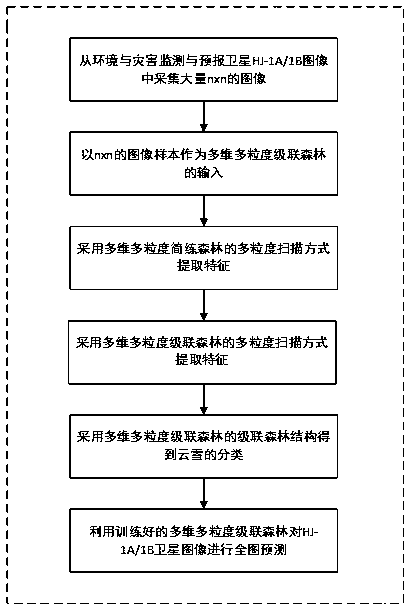
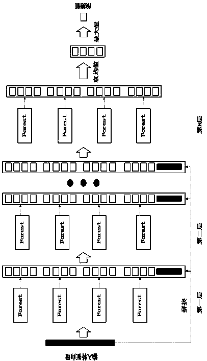
[0035] Such as figure 1 As shown, the cloud and snow classification method in the plateau area of ​​the multi-dimensional and multi-granularity cascaded forest of the present embodiment includes the following steps:

[0036]Step 1: Training of multi-dimensional and multi-granularity cascaded forest model structure: set the dimensions of multi-dimensional and multi-granularity scanning to be equal to the number of spectra, different a, b three different granularity windows and step size s, a, b satisfy a, bi ,Y i ), perform feature re-expression on the multi-dimensional and multi-granularity cascaded forest structure, use the multi-dimensional and multi-granularity scanned cascaded forest structu...


PUM


Abstract

The invention relates to a plateau area cloud snow classification method based on a multidimensional multi-granularity cascading forest. According to the method, a multidimensional multi-granularity scanning structure of the multidimensional multi-granularity cascading forest is utilized to perform spatial feature extraction on cloud snow image samples of a plateau area, spectral information of amultispectral image is extracted through a multidimensional scanning mode, and then the extracted spatial features and spectral information are used for training the cascading forest structure of themultidimensional multi-granularity cascading forest. Through the method, on the premise of improving accuracy, sample training speed and sample classification speed are higher than those in traditional convolution deep learning under the same hardware condition, and experiment results indicate that the result obtained through the method is good and is more suitable for cloud snow classification research on a satellite image.

Description

technical field [0001] The invention belongs to the technical field of computer vision, and in particular relates to a cloud and snow classification method in plateau areas based on multi-dimensional and multi-granularity cascading forests. Background technique [0002] With the continuous development of satellite remote sensing technology, the application of satellite remote sensing images is becoming more and more extensive, involving various aspects such as resource investigation, natural disasters, and environmental pollution. Among them, remote sensing satellites have also become the main technical means for snow disaster monitoring. However, there are many technical problems in cloud and snow classification, which are mainly reflected in three aspects. First, the surface characteristics of cloud and snow are complex; second, the similarity of cloud and snow spectral features; The lack of measurement accuracy of remote sensing image data. [0003] To solve the above pr...

Claims


Application Information

Patent Timeline
Patent Type & Authority Applications(China)
IPC IPC(8): G06K9/00G06K9/62G06N3/08
CPCG06N3/084G06V20/188G06F18/24G06F18/214
Inventor 翁理国刘万安张旭
Owner NANJING UNIV OF INFORMATION SCI & TECH
Learn More