Vegetation coverage area soil moisture inversion method based on Gaofen-3 satellite data

A technology of soil moisture and vegetation coverage, which is applied in the fields of electrical digital data processing, special data processing applications, complex mathematical operations, etc., and can solve problems such as low inversion accuracy

Inactive Publication Date: 2018-10-19
INST OF REMOTE SENSING & DIGITAL EARTH CHINESE ACADEMY OF SCI
View PDF3 Cites 17 Cited by
  • Summary
  • Abstract
  • Description
  • Claims
  • Application Information

AI Technical Summary

Problems solved by technology

[0005] Aiming at the problem of the first C-band SAR satellite independently developed by my country and the low accuracy of soil moisture retrieval in vegetation-covered areas, this inve

Method used


Image

  • Vegetation coverage area soil moisture inversion method based on Gaofen-3 satellite data
  • Vegetation coverage area soil moisture inversion method based on Gaofen-3 satellite data
  • Vegetation coverage area soil moisture inversion method based on Gaofen-3 satellite data

Examples


Embodiment Construction

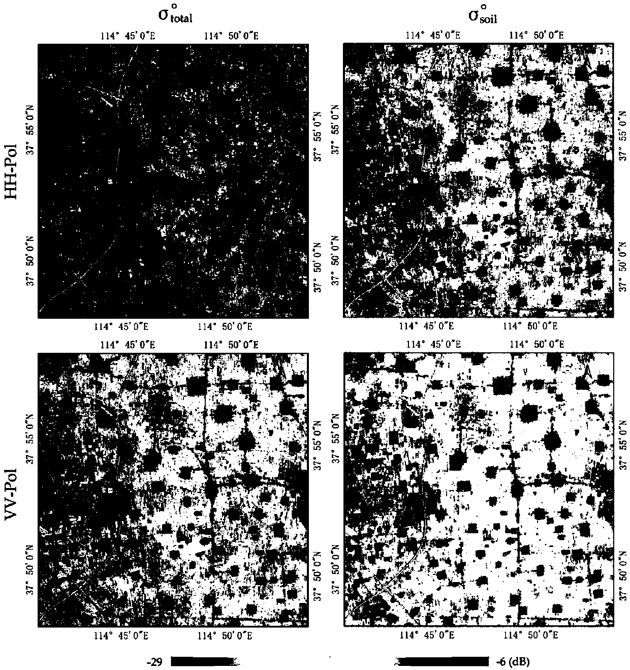
[0025] In the following, the present invention "a method for retrieving soil moisture in vegetation-covered areas based on Gaofen-3 data" will be further elaborated in conjunction with the accompanying drawings.

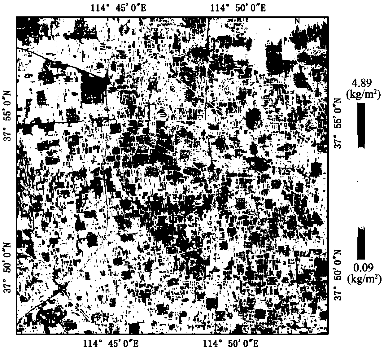
[0026] (1) Optimizing the best optical vegetation index to realize the inversion of vegetation water content in the study area

[0027] Based on 12 kinds of optical vegetation indices (MSI, MSI2, NMDI, NDI, NDII, NDVI, NDWI, EVI, SRWI, SWIRR, SIWSI and OSAVI), the fitting relationship with the field measured vegetation water content data was respectively established ( figure 1 ), and according to the goodness of fit R 2 The optimal optical vegetation index suitable for the study area is optimized to realize the inversion of vegetation water content in the study area ( figure 2 ). The calculation formula of each vegetation index is as follows:

[0028]

[0029] (For Landsat 8OLI optical remote sensing data, ρ red is the 4th band, ρ blue is the 2nd band, ρ ...


PUM


Abstract

Aiming at the first C-band SAR satellite independently developed by China and the problem that the inversion accuracy of soil moisture in the vegetation coverage area is low, the invention discloses avegetation coverage area soil moisture inversion method based on Gaofen-3 satellite data, which can realize the high-precision inversion of soil moisture in the vegetation coverage area. The method comprises the following steps: step 1) the best optical vegetation index suitable for the study area is preferentially selected to realize the vegetation moisture inversion; step 2) a co-polarization backscatter coefficient database is simulated according to the payload characteristics of the Gaofen-3 satellite and in combination with the AI EM model; step 3) the backscatter coefficient of bare soil after correcting the influence of vegetation optical thickness is calculated based on the improved water cloud model; and step 4) based on the newly established cost function Z, the difference of data in HH and VV polarization two channels is minimized simultaneously, and the nearest backscatter coefficient is obtained by matching, and the corresponding soil moisture is taken as the soil moisture of the pixel to realize the soil moisture inversion in the vegetation coverage area.

Description

technical field [0001] The present invention relates to a soil moisture inversion method in vegetation coverage area based on Gaofen-3 data. Aimed at my country's first self-developed C-band multi-polarization SAR satellite, a systematic and complete soil moisture inversion process is formed. Realize high-precision inversion of soil moisture in vegetation-covered areas. Background technique [0002] Soil moisture is an important part of the global energy cycle and an important parameter in the research of disciplines such as hydrology, meteorology and agronomy. Obtaining soil moisture information traditionally relies on station observations, which is time-consuming and laborious, and because the stations are sparsely distributed, it cannot fully reflect the spatial distribution characteristics of soil moisture. Synthetic aperture radar (SAR) has all-weather and all-weather observation capabilities, is less affected by clouds, rain, and snow, and can penetrate deeper into veg...

Claims


Application Information

Patent Timeline
IPC IPC(8): G06F17/50G06F17/15G01S7/41
CPCG01S7/41G06F17/15G06F30/20
Inventor 张琳琳孟庆岩姚舜雷志斌
Owner INST OF REMOTE SENSING & DIGITAL EARTH CHINESE ACADEMY OF SCI
Why Eureka
Try Eureka