Watershed multi-scale landscape pattern and water quality index relationship research method
A landscape pattern and multi-scale technology, applied in the field of remote sensing technology and landscape ecology, can solve problems such as the uncertainty of the optimal research scale, achieve the effect of optimizing the pattern and improving the contrast index
- Summary
- Abstract
- Description
- Claims
- Application Information
AI Technical Summary
Problems solved by technology
Method used
Image
Examples
Embodiment Construction
[0033] The technical solutions in the embodiments of the present invention will be clearly and completely described below. All other embodiments obtained by persons of ordinary skill in the art based on the embodiments of the present invention belong to the protection scope of the present invention. The present invention proposes a method for researching the relationship between watershed multi-scale landscape patterns and water quality indicators based on remote sensing technology, and the technical solution is realized in this way:
[0034] A method for researching the relationship between watershed multi-scale landscape patterns and water quality indicators based on remote sensing technology, comprising the following steps:
[0035] Step S1, extracting the source-sink pattern information of the watershed landscape combined with the "map" feature;
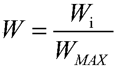
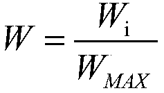
[0036] Step S2, the calculation of the landscape space load contrast index based on the minimum hydrological unit;
[0037] S...
PUM
 Abstract
Description
Claims
Application Information
 - R&D
- Intellectual Property
- Life Sciences
- Materials
- Tech Scout
- Unparalleled Data Quality
- Higher Quality Content
- 60% Fewer Hallucinations
Browse by: Latest US Patents, China's latest patents, Technical Efficacy Thesaurus, Application Domain, Technology Topic, Popular Technical Reports.
© 2025 PatSnap. All rights reserved.Legal|Privacy policy|Modern Slavery Act Transparency Statement|Sitemap|About US| Contact US: help@patsnap.com


