Aircraft listing method based on combination of video analysis and positioning information
A technology of positioning information and video analysis, applied in image analysis, geographic information database, instruments, etc., can solve the problems of unsatisfactory listing results, unsatisfactory results, false detection, etc.
- Summary
- Abstract
- Description
- Claims
- Application Information
AI Technical Summary
Problems solved by technology
Method used
Image
Examples
Embodiment Construction
[0032] Below in conjunction with accompanying drawing, mainly take airliner as example, the present invention will be further described.
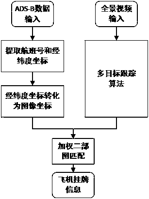
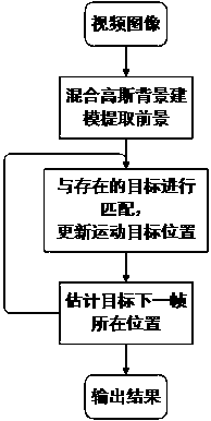
[0033] Such as Figure 1-3 As shown, the present invention relates to an aircraft listing method based on the combination of video analysis and positioning information, which needs to complete the acquisition of flight information of known aircraft, the mapping from latitude and longitude coordinates to image coordinates, and the video surveillance system uses multi-target tracking algorithm to detect aircraft The matching of target, latitude and longitude information and the result of target tracking (matching between known aircraft and aircraft target), the overall process is as follows (see figure 1 ):
[0034] Step 1. Obtain flight information
[0035] The flight information mainly includes the aircraft ID (flight number or other identification information), longitude and latitude information of known aircraft, etc., and the flight in...
PUM
 Abstract
Description
Claims
Application Information
 - R&D
- Intellectual Property
- Life Sciences
- Materials
- Tech Scout
- Unparalleled Data Quality
- Higher Quality Content
- 60% Fewer Hallucinations
Browse by: Latest US Patents, China's latest patents, Technical Efficacy Thesaurus, Application Domain, Technology Topic, Popular Technical Reports.
© 2025 PatSnap. All rights reserved.Legal|Privacy policy|Modern Slavery Act Transparency Statement|Sitemap|About US| Contact US: help@patsnap.com


