On-site operation safety risk management and control method based on geographic information aggregation

A technology for on-site operations and safety risks, applied in the field of on-site operation safety risk management and control based on geographic information aggregation, can solve the problems of irregular layout of risks and inability to browse the global risk distribution as a whole, so as to improve loading performance, interaction experience, The effect of reducing the number of markers

Inactive Publication Date: 2018-05-29
ZHUHAI POWER SUPPLY BUREAU GUANGDONG POWER GIRD CO
View PDF3 Cites 3 Cited by
  • Summary
  • Abstract
  • Description
  • Claims
  • Application Information

AI Technical Summary

Problems solved by technology

[0005] 3. There are certain limitations in the area displayed by mobile devices. After the risk points are directly tiled and displayed, the visible area is restricted, and it is impossible to browse the overall risk distribution as a whole;
[0006] 4. The layout of risks is irregular, and it is impossible to implement effective risk management and control according to the risk measures required by the risk management and control business, such as regional bureaus, departments, and inspection centers.

Method used


Image

  • On-site operation safety risk management and control method based on geographic information aggregation

Examples


Embodiment 1

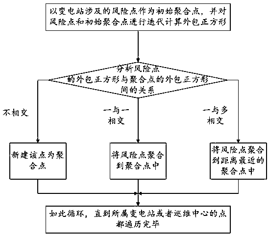
[0030] Such as figure 1 Shown is the first embodiment of the on-site operation safety risk management and control method based on geographical information aggregation of the present invention, using a point aggregation algorithm based on the combination of squares and distances, and the level to which the risk belongs, to map the risk of the global power grid on the electronic map When the scale is reduced or enlarged on the map, the lowest-level map positioning points are automatically aggregated upwards or decomposed downwards, and a small number of points or icons are used to represent them. The number of risk points in a certain area on the map makes the display of risk points on the map more clear and clear, and realizes the management and control of the overall safety production risk. In this embodiment, the number of risk points in the global power grid is 200-1100, the number of aggregation points is 10-80, and the number of risk points included in each aggregation poi...


PUM


Abstract

The invention relates to the technical field of power grid risk management and control, in particular to an on-site operation safety risk management and control method based on geographic informationaggregation. The method comprises the steps that upward aggregation and downward decomposition of risks of risk points of the whole power grid on an electric map are performed by adopting a point aggregation algorithm based on the combination of grids and distance and levels of the risks. According to the method, multiple points are upwardly aggregated to be marking points of a map by means of thepoint aggregation algorithm of the map, the number of markers of the map is greatly reduced, the risk points on the map do not cover a base map of the electric map, an overall risk condition of a specific zone can be checked by users clearly, and therefore management and control of a global safety and production risk are achieved; the method has the advantages that resource overhead of a front end can be relieved, and loading performance of the map and interaction performance of the users are improved.

Description

technical field [0001] The present invention relates to the technical field of risk management and control of power grids, and more specifically, to a method for managing and controlling safety risks of on-site operations based on geographic information aggregation. Background technique [0002] At present, risk information buckets such as power grid risk, operation risk, and power grid events in the safety production system only publish risk description information and risk control measure requirements in the form of a structured form, as well as feedback process management of the implementation of risk control measures; risk sand table system Through the use of geographic information positioning technology to dynamically monitor structured risk data on the map, the blind area of ​​real-time control of power grid security risks is solved, but the following technical problems still exist: [0003] 1. There are hundreds or even thousands of on-site operation risks every day. ...

Claims


Application Information

Patent Timeline
Patent Type & Authority Applications(China)
IPC IPC(8): G06Q10/06G06Q50/06
CPCG06Q10/0635G06Q50/06Y04S10/50
Inventor 皮霄林游雪峰王力伟林玮玲王强廖石江黎锐烽邓丽芬张烁郭斯晓裴星宇喻厅王志银廖泽浩王永鹏
Owner ZHUHAI POWER SUPPLY BUREAU GUANGDONG POWER GIRD CO
Why Eureka
Try Eureka