
Agricultural drought monitoring method for multi-source remote sensing data

A technology of remote sensing data and remote sensing monitoring, applied in the field of agricultural drought monitoring, can solve the problems of cumbersome implementation, not taking much consideration of soil moisture changes, etc., and achieve the effect of avoiding the low precision of drought monitoring.

Inactive Publication Date: 2018-03-09
BEIJING NORMAL UNIVERSITY
View PDF5 Cites 42 Cited by
  • Summary
  • Abstract
  • Description
  • Claims
  • Application Information

AI Technical Summary

Problems solved by technology

[0004] Although the above method uses remote sensing data for drought monitoring, due to its cumbersome implementation, it can only determine the drought situation, and only considers the vegetation index and surface temperature, without much consideration of the change of soil moisture. The prediction of farmland soil moisture is both It is the focus of research on water balance of farmland and water transformation in the soil-plant-atmosphere continuum, and it is also the best indicator factor to characterize agricultural drought

Method used


Image

  • Agricultural drought monitoring method for multi-source remote sensing data
  • Agricultural drought monitoring method for multi-source remote sensing data
  • Agricultural drought monitoring method for multi-source remote sensing data

Examples


Embodiment 1

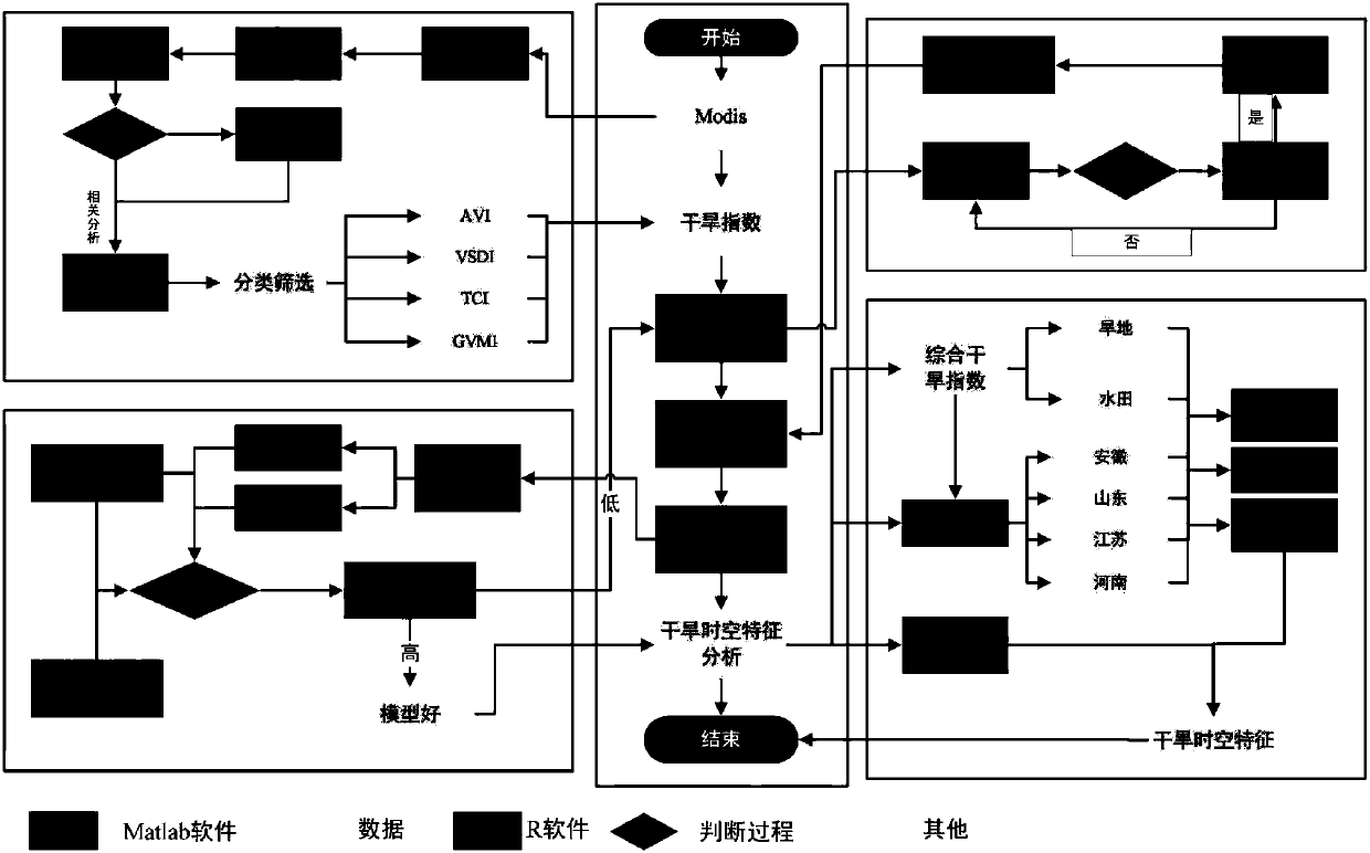
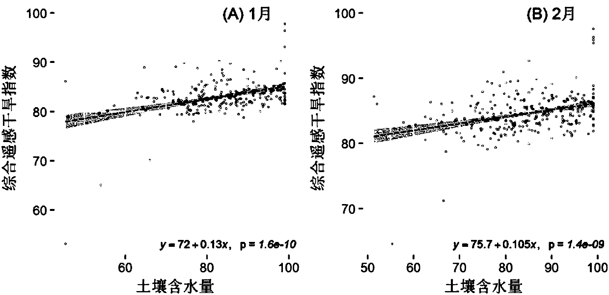
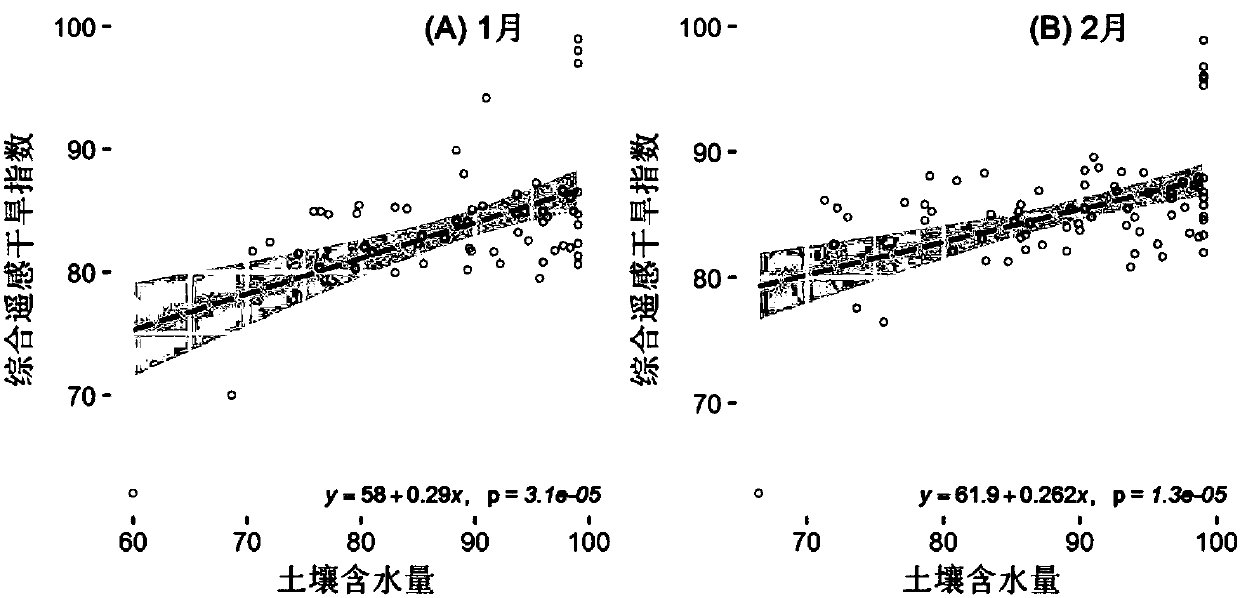
[0070] Example 1, such as figure 1 As shown, it is the construction process of the comprehensive remote sensing drought index of multi-source data, figure 2 It is a schematic diagram of the correlation coefficient between the comprehensive remote sensing drought index and the soil moisture of the modeling site. It is found that the correlation coefficient between the comprehensive remote sensing drought index and the soil moisture has passed the 99% significance test, and the fitting accuracy of the multiple linear regression equation with soil moisture as the dependent variable is is very high; and in order to better reflect the applicability of the constructed model, such as image 3 As shown, the correlation analysis between the soil moisture stations not involved in the modeling and the monthly-scale comprehensive remote sensing drought index was carried out, and the results found that all passed the 99% significance test, indicating that it can well reflect the 20cm soil...


PUM


Abstract

The invention provides an agricultural drought monitoring method for multi-source remote sensing data. According to the method, the following most frequently used four categories of agricultural drought remote sensing monitoring indexes (including 16 indexes) are selected: crop canopy temperature change ( 4 indexes), crop form and vegetation greenness change (5 indexes), soil water change (3 indexes) and crop canopy water contents (4 indexes); a constructed comprehensive remote-sensing drought model is checked and corrected by standard potential evapotranspiration indexes SPEI of a monitoringsite of a research region and 20 cm soil moisture status data, and drought of a data acquiring region can be monitored and evaluated in a large range. By the method, agricultural drought can be continuously, dynamically, quantitatively and visually monitored, analyzed and researched on fine space scale, and decision support and information service are provided for prevention and reduction of natural disasters.

Description

technical field [0001] The invention relates to the technical field of agricultural drought monitoring, in particular to a method for agricultural drought monitoring based on multi-source remote sensing data. Background technique [0002] At present, there are many studies on the agricultural drought monitoring index. Under the current climate warming environment, the frequency of drought is gradually increasing, so the platform for drought monitoring and early warning and drought monitoring has become a popular research for many researchers. field. [0003] Among the current similar technologies, the patent number "Agricultural Drought Monitoring Method Based on MODIS Data" applied by the Shenyang Institute of Applied Ecology, Chinese Academy of Sciences is typically CN200910248457.3: this patent is an agricultural drought monitoring method based on MODIS data. Monitor farmland drought, and use crop water supply index and rainfall anomaly index to determine agricultural dr...

Claims


Application Information

Patent Timeline
Patent Type & Authority Applications(China)
IPC IPC(8): G01N21/55
CPCG01N21/55
Inventor 张强孙鹏
Owner BEIJING NORMAL UNIVERSITY
Learn More