Mountain torrent critical rainfall calculation method based on rainstorm characteristics
A calculation method and mountain torrent technology, applied in the fields of calculation, climate change adaptation, and data processing applications, can solve problems such as large changes in calculation results, lack of mountain torrent disaster data, and lack of river regulation projects, achieving high accuracy and saving manual calculations. The effect of time and cost
- Summary
- Abstract
- Description
- Claims
- Application Information
AI Technical Summary
Problems solved by technology
Method used
Image
Examples
Embodiment 1
[0037] A method for calculating critical rainfall based on torrential rain features torrents, said calculation method comprising the steps of:
[0038] Selection of geographical location: The selected location is Yudu County, Jiangxi Province, located in the east of Ganzhou City, with a total area of 2893 square kilometers and an average annual precipitation of 1507 mm. The landform in the territory is complex, with higher terrain in the south, east and north, gradually inclining to the central and west, forming a closed hilly and low-mountain landform dominated by low mountains, hills and basins, with large and small rivers collecting tribute water. Yudu County is located in the upper reaches of the Gongshui River, which is the source of the Ganjiang River. It gathers 4 major tributaries, including the Meijiang River, Chengjiang River, Lianshui River, and Xiaoxi River.
[0039] According to the mountain torrent survey and evaluation results of Ganzhou City Hydrology Bureau ...
Embodiment 2
[0088] Using the cloud computing platform for intelligent computing, first build a mountain torrent critical rainfall cloud computing platform, as follows:
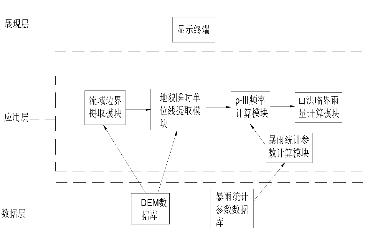
[0089] Described cloud computing platform comprises data layer, application layer and display layer, and data layer provides the data used for computing for the module in application layer; Application layer provides calculation result to display layer; Display the data and support display device display.
[0090] The data layer includes a DEM database and a rainstorm statistical parameter database; the application layer includes a drainage basin boundary extraction module, a landform instantaneous unit line extraction module, a p-III frequency calculation module and a mountain torrent critical rainfall calculation module connected in sequence, and also includes a rainstorm statistical parameter calculation module; wherein, the watershed boundary extraction module and the landform instantaneous unit line extraction module...
PUM
 Abstract
Description
Claims
Application Information
 - R&D Engineer
- R&D Manager
- IP Professional
- Industry Leading Data Capabilities
- Powerful AI technology
- Patent DNA Extraction
Browse by: Latest US Patents, China's latest patents, Technical Efficacy Thesaurus, Application Domain, Technology Topic, Popular Technical Reports.
© 2024 PatSnap. All rights reserved.Legal|Privacy policy|Modern Slavery Act Transparency Statement|Sitemap|About US| Contact US: help@patsnap.com


