
Device for measuring elevation of road cross square grid

A measurement device and grid grid technology, applied in the field of measurement, can solve the problems of large manpower input, difficulty in ensuring measurement accuracy, cumbersome workload, etc., and achieve the effects of reduced workload, flexible data observation angle, and improved work efficiency

Pending Publication Date: 2017-11-21
上海山南勘测设计有限公司
View PDF0 Cites 3 Cited by
  • Summary
  • Abstract
  • Description
  • Claims
  • Application Information

AI Technical Summary

Problems solved by technology

It can be seen that the biggest disadvantage of the above method is that the workload is cumbersome, the investment of manpower is large, and the measurement accuracy is difficult to be guaranteed.

Method used


Image

  • Device for measuring elevation of road cross square grid

Examples


Embodiment

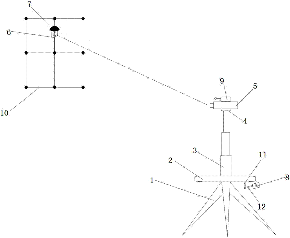
[0021] Such as figure 1 As shown, a measuring device for the elevation of the road intersection grid includes a tripod 1, a horizontal workbench 2 arranged on the top of the tripod 1, and a multi-section telescopic Rod 3, the rotating round table 4 that is arranged on the top of the multi-section telescopic rod 3, the total station 5 fixed on the rotating round table 4, the circular prism 6 that is arranged on the square grid 10 to be measured and used in conjunction with the total station 5, A GPS-RTK measuring receiver 7 fixedly connected to the circular prism 6, a digital display controller 8 electrically connected to the total station 5 and the GPS-RTK measuring receiver 7 respectively.

[0022] Wherein, a speech recognizer 9 is arranged on the top of the total station 5 , and the speech recognizer 9 is electrically connected with the digital display controller 8 . The top of the circular prism 6 is provided with a chopping block. The GPS-RTK measuring receiver 7 is fixe...


PUM


Abstract

The invention relates to a measuring device for the elevation of the road crossing grid, which comprises a tripod, a horizontal workbench arranged on the top of the tripod, multi-section telescopic rods arranged on the horizontal workbench along the vertical direction, The rotating round table set on the top of the multi-section telescopic pole, the total station fixed on the rotating round table, the circular prism set on the grid to be measured and used in conjunction with the total station, the GPS-RTK measurement receiver fixedly connected with the circular prism The digital display controller is electrically connected with the total station and the GPS‑RTK measuring receiver respectively. Compared with the prior art, the overall structure of the present invention is simple and compact, and the operation is convenient and flexible. It has a long service life and has a good application prospect.

Description

technical field [0001] The invention belongs to the technical field of measurement, and relates to a measuring device for the elevation of a road crossing grid. Background technique [0002] The elevation measurement of road intersection grid is an important design basis for the design of road longitudinal slope and edge joint, and is a major task in the measurement task of municipal road engineering projects. The existing measurement process is mainly to use GPS-RTK to set out the road intersection grid first, then mark the points, and then use a total station or a level to measure the elevation of all the marked points. This requires three surveyors, one for GPS-RTK point placement, one for running poles, and one for operating total station survey points. Simultaneously, since the point is placed first for marking, and then the point is measured, the position of the point and the point for measurement inevitably deviates. It can be seen that the biggest disadvantage of t...

Claims


Application Information

Patent Timeline
Patent Type & Authority Applications(China)
IPC IPC(8): G01C5/00
CPCG01C5/00
Inventor 周俊程强丁海建
Owner 上海山南勘测设计有限公司
Learn More