Preliminary judgment method for slope stability based on terrain and geologic map

A discrimination method and geological map technology, applied in excavation, infrastructure engineering, construction, etc., can solve problems such as time-consuming, heavy workload, inapplicable slope stability and preliminary assessment of site suitability, etc., to achieve strong pertinence , high reliability, good practical effect

Inactive Publication Date: 2017-11-14
CHONGQING UNIV
View PDF4 Cites 10 Cited by
  • Summary
  • Abstract
  • Description
  • Claims
  • Application Information

AI Technical Summary

Problems solved by technology

[0003] At present, in the site selection stage in the early stage of project construction, subjective judgments are generally made on the slope stability and site safety based on the collection of terrain and other data; if further objective, effecti...

Method used


Image

  • Preliminary judgment method for slope stability based on terrain and geologic map
  • Preliminary judgment method for slope stability based on terrain and geologic map
  • Preliminary judgment method for slope stability based on terrain and geologic map

Examples


Embodiment Construction

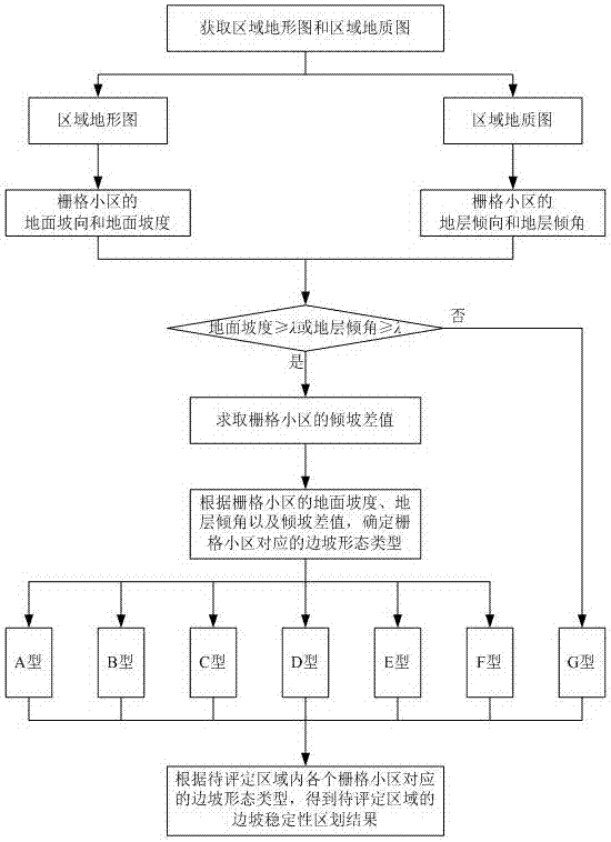
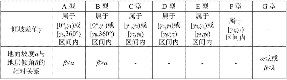
[0030] Facing the problems of the existing slope stability investigation and evaluation technology, which are heavy workload, time-consuming, and have limited reference significance for engineering construction, the present invention provides a preliminary judgment method for slope stability based on topographic and geological maps. Such as figure 1 shown, including the following steps:

[0031] 1) Obtain the regional topographic map and regional geological map of the area to be assessed.

[0032] In this step, the scale of the obtained regional topographic map and regional geological map is preferably not less than 1:10000, so as to better ensure that the regional topographic map and regional geological map can refine and characterize the different local positions in the area to be evaluated. Slope related properties.

[0033] 2) Generate a digital elevation model of the area to be assessed according to the regional topographic map, and determine the occurrence of each stra...


PUM


Abstract

The invention provides a preliminary judgment method for slope stability based on a terrain and geologic map. The method comprises the following steps: utilizing an area terrain map and an area geologic map as main characteristic data for evaluating the slope stability; extracting the parameters capable of finely representing the characteristics related to the slope forms in different local areas in a to-be-evaluated area from the main characteristic data; classifying the divided forms according to the parameter data and confirming the categories of slope forms in different local areas in the to-be-evaluated area, thereby realizing the preliminary evaluation for the slope stability in the to-be-evaluated area. The acquired evaluation result for the slope stability has the characteristics of high specificity, high reliability and high practicability, can be used for preliminarily judging the slope stability in the to-be-evaluated area, can be used for quickly and preliminarily checking the hidden danger of areal geological disasters, has higher accuracy and guidance and is capable of supplying valid reference information to the applications of geological disaster prevention and control, engineering construction, building construction, and the like.

Description

technical field [0001] The invention relates to the technical field of engineering geology and geological disaster exploration and prediction, in particular to a method for preliminary determination of slope stability based on topographic and geological maps. Background technique [0002] my country's mountainous area accounts for 2 / 3 of the country's land area. In recent years, my country's engineering construction is in a stage of great development. Engineering construction is affected by the engineering environment. In the mountainous environment, the influence of slope stability even determines the form, scale, and Safety, cost, construction period and other aspects. Especially in the southwestern mountainous area, the geological conditions are complex, and the engineering construction is greatly affected by the geological environment such as the stratum geological structure. In order to ensure the safety of the engineering construction, we need to quickly and effectively...

Claims


Application Information

Patent Timeline
IPC IPC(8): G06F17/50E02D17/20
CPCE02D17/20G06F30/20
Inventor 文海家王桂林黄雪浪薛靖元谢朋张岩岩
Owner CHONGQING UNIV
Why Eureka
Try Eureka