Rare earth mine area land damage and recovery analysis method based on multi-source timing sequence images

A rare earth mining area and analysis method technology, applied in the direction of instruments, character and pattern recognition, scene recognition, etc., can solve the problems of difficult application and promotion, time-consuming and laborious, technical methods and financial constraints, etc., and achieves easy promotion, high efficiency, and related characteristics. The effect of description refinement

Active Publication Date: 2017-09-15
JIANGXI UNIV OF SCI & TECH
View PDF6 Cites 3 Cited by
  • Summary
  • Abstract
  • Description
  • Claims
  • Application Information

AI Technical Summary

Problems solved by technology

[0003] At present, the land damage and restoration analysis methods in mining areas mainly include the land damage and restoration evaluation model based on measured data and the dynamic monitoring of land damage and restoration process based on remote sensing data. The former method not only requires a large amount of measured data, but is time-consuming and laborious. In addition, different models need to be established for different locations, and it is difficult to apply and promote them. Due to the limitation of technical methods and funds, the early dynamic monitoring of land damage and restoration process mostly uses a few remote sensing images with long intervals and no clouds. The research method is multi-time Facies classification post-comparison method, which can reflect the spatial distribution of surface object type changes, but little is known about the process of surface object type change; the continuous enrichment of remote sensing data sources and the development of remote sensing time series analysis methods provide a basis for improving The understanding of ecological processes on broad spatio-temporal scales offers major opportunities

Method used


Image

  • Rare earth mine area land damage and recovery analysis method based on multi-source timing sequence images
  • Rare earth mine area land damage and recovery analysis method based on multi-source timing sequence images
  • Rare earth mine area land damage and recovery analysis method based on multi-source timing sequence images

Examples


Embodiment Construction

[0038] Such as figure 1 with figure 2 As shown in the present invention, a multi-source time-series image land damage and restoration analysis method for rare earth mining areas includes the following steps,

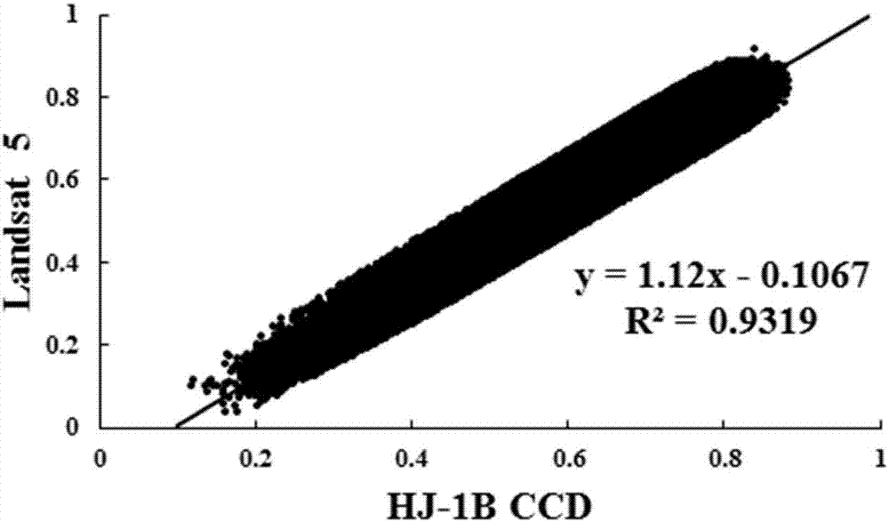
[0039] Step S1: Acquisition of data in the study area. The original remote sensing images needed for the study area are obtained through the data acquisition unit; including Landsat 5 TM, Landsat 8 OLI and HJ-1B CCD remote sensing images with a spatial resolution of 30m.

[0040] Step S2: data preprocessing, the remote sensing data obtained in step S1 is radiometrically calibrated to the original image through the radiometric calibration module, after the radiometric calibration, the atmospheric correction module is used to perform atmospheric correction, and after the atmospheric correction, the geometric correction module is used to correct the image. After geometric correction, the image cropping module was used to obtain the remote sensing image of the study area. ...


PUM


Abstract

The invention relates to the technical field of land recovery analysis, in particular to a rear earth mine area land damage and recovery analysis method based on multi-source timing sequence images. The method comprises following steps of step S1, researching regional data acquisition; step S2, data processing and carrying out radiation correction, atmospheric correction, geometric correction and image cutting on the acquired original remote sensing image so as to obtain a remote sensing image of the researched region; step S3, calculating vegetation indexes; step S4, constructing a transfer equation; and step S5, converting NDVI determining relevant parameters of the timing sequence analysis method, and carrying out quantitative analysis for the land damage and recovery. According to the invention, surface information of a rear earth mine region can be acquired in real time quickly in large area. Compared with the traditional analysis method based on measured data modeling, the provided method is quite high in efficiency, quite simple to apply and quite easy to promote. In addition, by use of the timing sequence analysis method, relative features of land damage and recovery processes in a rear earth exploiting environment are analyzed and the relative features are described in a quite detailed manner.

Description

technical field [0001] The invention relates to the technical field of land restoration analysis, in particular to a method for analyzing land damage and restoration in rare earth mining areas with multi-source time-series images. Background technique [0002] Ionic rare earth ore was first discovered in Jiangxi, my country in 1969. It has the advantages of wide distribution, abundant reserves, low radioactivity, complete distribution of rare earth, and rich in medium and heavy rare earth elements. It is a unique rare earth mineral resource in my country and is also rare in the world Minerals are widely distributed in Jiangxi, Fujian, Hunan, Guangdong, Guangxi and other provinces in southern my country, of which Jiangxi Province has the largest share. The mining techniques mainly include pool leaching, heap leaching and in-situ leaching. The two mining processes of pool leaching and heap leaching need to strip the ore body and topsoil vegetation, resulting in huge damage to ...

Claims


Application Information

Patent Timeline
IPC IPC(8): G06K9/00
CPCG06V20/188G06V20/13
Inventor 李恒凯雷军杨柳王秀丽
Owner JIANGXI UNIV OF SCI & TECH
Why Eureka
Try Eureka