Dynamic three-dimensional-scene virtual-landform visual rapid discrimination method

A technology of three-dimensional scene and discrimination method, which is applied in image data processing, 3D image processing, instruments, etc., and can solve the problem of inability to detect the visual field in real time.

Inactive Publication Date: 2017-07-18
CHANGCHUN UNIV OF SCI & TECH
View PDF3 Cites 2 Cited by
  • Summary
  • Abstract
  • Description
  • Claims
  • Application Information

AI Technical Summary

Problems solved by technology

For an environment containing N entities, one needs to do O( n 2 ) order of magnitude inspection calculation, in the 3D dynamic scene, it is impossible to detect the visual field of the point in real time

Method used


Image

  • Dynamic three-dimensional-scene virtual-landform visual rapid discrimination method
  • Dynamic three-dimensional-scene virtual-landform visual rapid discrimination method
  • Dynamic three-dimensional-scene virtual-landform visual rapid discrimination method

Examples


Embodiment Construction

[0041] In order to make the features and advantages of the method more clear, the method will be further described below in conjunction with specific embodiments. In this embodiment, two kinds of terrain data are considered: 1) DEM real data, and 2) virtual terrain data generated based on Perlin noise. The CPU of the computer system is Intel(R) Xeon(R) CPU E5620@ dual-core 2.40GHz, the memory is Kingston 8GB DDR3 1333, the hard disk is Buffalo HD-CE 1.5 TU2; the graphics card is NVIDIA Quadrok5000, the computer operating system is Windows 7, software programming The tool uses VC++ 2010.

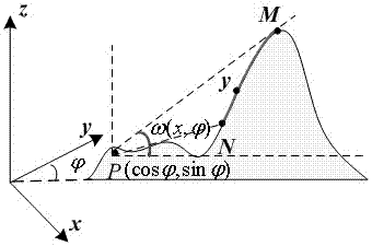
[0042] A method for quickly discriminating visibility of virtual terrain in a dynamic three-dimensional scene is characterized in that: the method is composed of three parts. The first part is to construct a proxy bounding box for the initial virtual terrain. Design a visibility function , the local maximum and minimum values ​​of the basic points of the geometric primitives are randomly s...


PUM


Abstract

The invention relates to a dynamic three-dimensional-scene virtual-landform visual rapid discrimination method. The method is characterized in that the method comprises three portions; in a first portion, aiming at an initial virtual landform, an agent bounding box is formed; a visibility function is designed; local maximum and minimum values of a basic point of a geometric graphic element are randomly extracted; and through the visibility function, a test wire used for approximation detection is intersected with a virtual landform. In the method, through designing one agent bounding box of the virtual landform, an intersection point of the test wire and a scene is rapidly detected; and through designing a phase-type parallel height field scanning algorithm, a maximum aspect angle of any one point in the scene is pre-calculated so that complexity of a traditional scanning method is effectively reduced and point-to-point visibility discrimination efficiency of the virtual landform in a three-dimensional virtual scene is increased.

Description

technical field [0001] The invention relates to a method for quickly discriminating the visibility of a virtual terrain in a dynamic three-dimensional scene, which is a method for quickly discriminating the visibility of a point-to-point in a virtual terrain in a dynamic three-dimensional scene through forward staged parallel scanning, and belongs to the technical field of three-dimensional graphics rendering. Background technique [0002] Terrain is one of the most important components of natural scenes, and terrain rendering is the main research content of realistic rendering. Digital Elevation Model (DEM) is a discrete digital landform model, interactive visualization of terrain based on DEM is an important research content of scientific visualization, flight simulation, virtual reality, and interactive 3D games. In theory, terrain visibility judgment needs to calculate the occlusion relationship from vertices in all directions. For a size of n x n The height field vir...

Claims


Application Information

Patent Timeline
IPC IPC(8): G06T15/00
Inventor 李华杨华民陈纯毅蒋振刚韩成丁岩权巍薛耀红
Owner CHANGCHUN UNIV OF SCI & TECH
Why Eureka
Try Eureka