Photogrammetric survey absolute orientation method by utilizing center coordinates of GNSS antenna

A technology of photogrammetry and center coordinates, which is applied in photogrammetry/video metrology, radio wave measurement system, satellite radio beacon positioning system, etc. It can solve the problem of high price and low-altitude photogrammetry accuracy. , Geometric size and product weight can only be applied and other issues, to achieve the effect of low cost

Active Publication Date: 2017-07-18
SOUTHEAST UNIV
View PDF7 Cites 7 Cited by
  • Summary
  • Abstract
  • Description
  • Claims
  • Application Information

AI Technical Summary

Problems solved by technology

Not only are they expensive, but the geometry and product weight can only be applied to large UAVs
The attitude and positioning accuracy of MIMU / GNSS, the flight navigation system of small rotor UAVs, cannot meet the accuracy requirements of relevant specifications in low-altitude photogrammetry (General Administration of Quality Supervision, Inspection and Quarantine of the People's Republic of China, Standardization Administration of China. "IMU / GPS Auxiliary aerial photography technical specification "GB / T27919.1-2011)

Method used


Image

  • Photogrammetric survey absolute orientation method by utilizing center coordinates of GNSS antenna
  • Photogrammetric survey absolute orientation method by utilizing center coordinates of GNSS antenna
  • Photogrammetric survey absolute orientation method by utilizing center coordinates of GNSS antenna

Examples


Embodiment Construction

[0033] The technical solution of the present invention will be described in detail below in conjunction with the accompanying drawings.

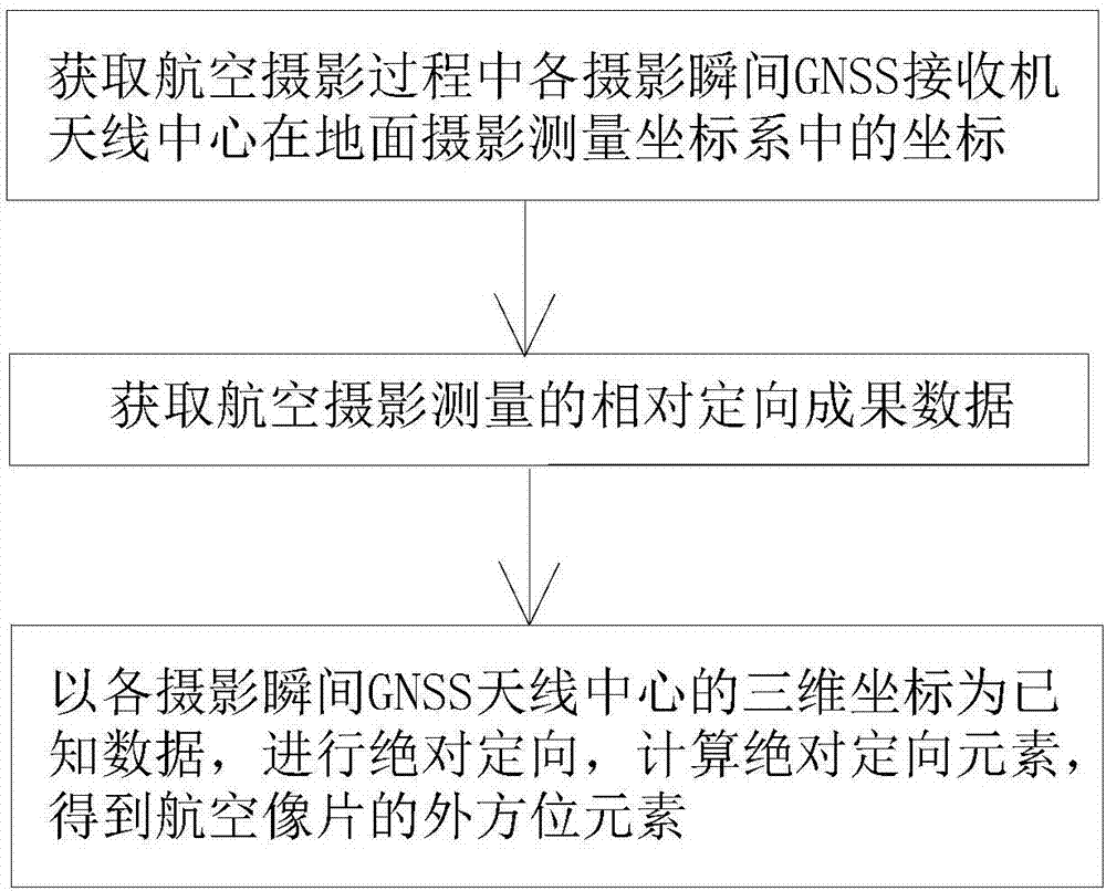
[0034] Such as figure 1 As shown, a method of using the central coordinates of the GNSS antenna to perform photogrammetry absolute orientation in the embodiment of the present invention includes:

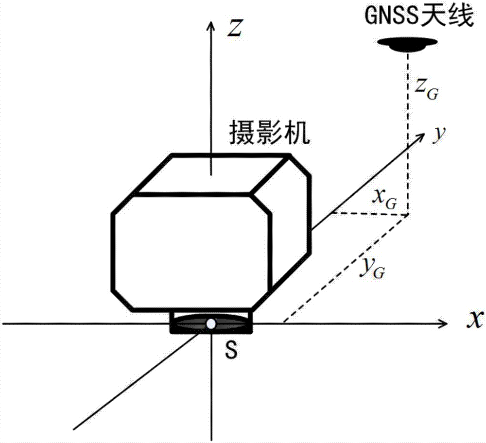
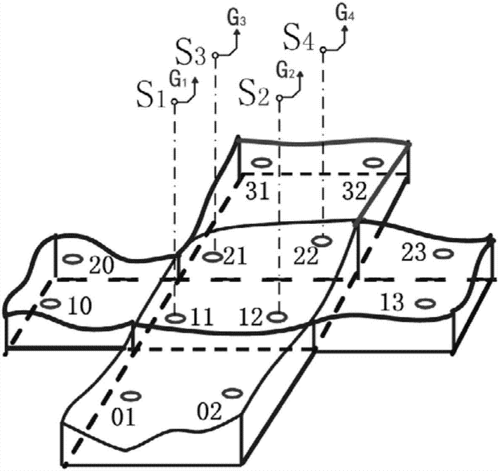
[0035] Step 10) Obtain the coordinates of the GNSS receiver antenna center in the ground photogrammetry coordinate system at each photographing moment in the aerial photography process represents the abscissa of the antenna center, Indicates the ordinate of the antenna center, Indicates the elevation of the antenna center, and j indicates the photo number in the photographing area;

[0036] Step 20) Obtain the relative orientation result data of aerial photogrammetry, the data includes the three-dimensional coordinates of the center of the objective lens at the instant when each photo is taken and the opposite corner element of the photo (...


PUM


Abstract

The invention discloses a photogrammetric survey absolute orientation method by utilizing center coordinates of an GNSS antenna. The method comprises the following steps: (10) acquiring coordinates of the center of each photogrammetric instant GNSS receiver antenna in a terrestrial photogrammetric coordinate system during the aerial photographing process; (20) acquiring data of relative orientation results of aerial photogrammetric survey; and (30) performing absolute orientation by using three-dimensional coordinates of the center of each photogrammetric instant GNSS antenna as known data, and calculating the absolute orientation element to obtain an exterior orientation element of an aerial photograph. The method can realize photogrammetric survey of no ground control point without precise IMU.

Description

technical field [0001] The invention belongs to the field of photogrammetry, and in particular relates to a method for absolute orientation of photogrammetry by using the antenna center coordinates of the Global Navigation Satellite System (English full name: Global Navigation Satellite System, abbreviated as GNSS). Background technique [0002] Photogrammetry includes two important processes of relative orientation and absolute orientation. Relative orientation does not require ground control points, while absolute orientation often requires ground control points to achieve, and photogrammetry methods without ground control points require the support of high-precision POS systems (attitude positioning systems). At present, two high-precision IMU / DGPS systems commonly used in the world are the POS AV series products of Applanix in Canada and the AEROcontrol series products of IGI in Germany (Zhang Zuxun, Zhang Jianqing. Digital Photogrammetry. Wuhan University Press Publishi...

Claims


Application Information

Patent Timeline
Patent Type & Authority Applications(China)
IPC IPC(8): G01C11/00G01S19/42
CPCG01C11/00G01S19/42
Inventor 沙月进
Owner SOUTHEAST UNIV
Why Eureka
Try Eureka