Block type rural settlement place remote sensing fast labeling method

A technology for residents and rural areas, applied in character and pattern recognition, special data processing applications, instruments, etc., can solve the problems that the degree of algorithm automation cannot reach a practical level, the labeling process is cumbersome and time-consuming, and the classification accuracy is low, achieving good results. Guarantee automation and real-time requirements, and reduce the effect of cumbersomeness

Inactive Publication Date: 2017-06-23
INST OF GEOGRAPHICAL SCI & NATURAL RESOURCE RES CAS
View PDF7 Cites 2 Cited by
  • Summary
  • Abstract
  • Description
  • Claims
  • Application Information

AI Technical Summary

Problems solved by technology

[0003] There are two main problems in the existing high-resolution remote sensing image settlement information extraction algorithms: first, the algorithm based on the supervised classification mechanism requires a large number of manually labeled training samples, the labeling process is cumbersome and time-consuming, and the degree of automation of the algorithm cannot be practical. Second, although the algorithm based on the unsupervised mechanism does not require training samples, its classification accuracy is relatively low and needs to be further improved

Method used


Image

  • Block type rural settlement place remote sensing fast labeling method
  • Block type rural settlement place remote sensing fast labeling method
  • Block type rural settlement place remote sensing fast labeling method

Examples


Embodiment Construction

[0049] The specific embodiments of the present invention are described below so that those skilled in the art can understand the present invention, but it should be clear that the present invention is not limited to the scope of the specific embodiments. For those of ordinary skill in the art, as long as various changes Within the spirit and scope of the present invention defined and determined by the appended claims, these changes are obvious, and all inventions and creations using the concept of the present invention are included in the protection list.

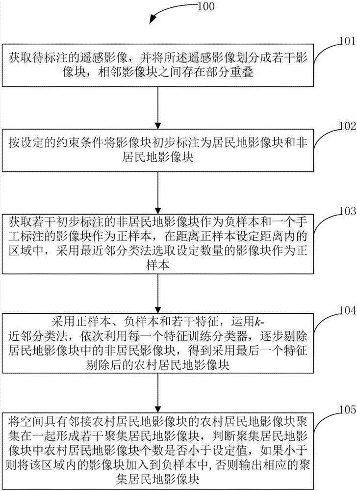
[0050] refer to figure 1 , figure 1A flow chart of an embodiment of a block-style rural residential area rapid remote sensing labeling method is shown; figure 1 As shown, the method 100 includes step 101 to step 105 .

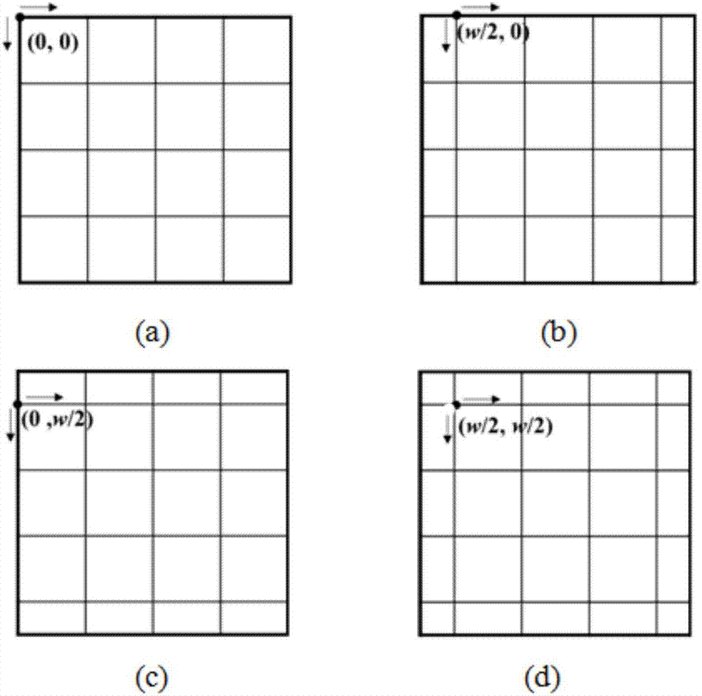
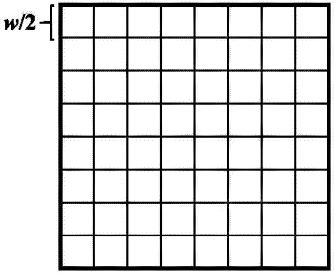
[0051] In step 101, the remote sensing image to be marked is obtained, and the remote sensing image is divided into several image blocks (the window side length of the image block in this program is select...


PUM


Abstract

The invention discloses a block type rural settlement place remote sensing fast labeling method. The method comprises the steps of obtaining a remote sensing image to be labeled, and dividing the remote sensing image into multiple image blocks; primarily labeling the image blocks as settlement place image blocks and non-settlement place image blocks according to a set constraint condition; obtaining the multiple primarily labeled non-settlement place image blocks as a negative sample and one manually labeled image block as a positive sample, and adopting a nearest neighbor classification method to choose the image blocks of a preset number as the positive sample; adopting the positive sample, the negative sample and multiple characteristics and adopting a k-nearest neighbor classification method to gradually remove the non-settlement place image blocks in the settlement place image blocks; gathering the rural settlement place image blocks which have the adjacent rural settlement place image blocks in space together to form multiple agminated settlement place image blocks, judging whether the number of the rural settlement place image blocks in the agminated settlement place image blocks is smaller than a set value or not, if the number is smaller than the set value, adding the agminated settlement place image blocks into the negative sample, or, outputting the corresponding agminated settlement place image blocks.

Description

technical field [0001] The invention relates to a marking technology of residential areas in remote sensing images, in particular to a rapid remote sensing marking method of block-type rural residential areas. Background technique [0002] With the continuous improvement of the spatial resolution of remote sensing images, remote sensing images provide more detailed information such as geometry, texture, shape, etc., and the internal composition and external contours of residential areas can be better displayed on remote sensing images. Information on the spatial distribution of residential areas becomes possible. However, the interior of residential areas is composed of buildings, roads, green spaces, shadows, etc., and the spectra of different components are quite different. It is difficult to extract residential area information only by using spectral information. The technical difficulty of the extraction algorithm. In order to solve this technical problem and serve the...

Claims


Application Information

Patent Timeline
IPC IPC(8): G06F17/30G06K9/20G06K9/38G06K9/46G06K9/62
CPCG06F16/5866G06V10/16G06V10/10G06V10/28G06V10/44G06V10/50G06F18/24133G06F18/214
Inventor 杨晓梅陆尘周成虎
Owner INST OF GEOGRAPHICAL SCI & NATURAL RESOURCE RES CAS
Why Eureka
Try Eureka