A 3D Terrain Rendering Method for Airborne Synthetic Vision

A technology of 3D terrain and synthetic vision, applied in 3D image processing, instrumentation, calculation, etc., can solve problems such as difficulty in ensuring real-time performance and large amount of calculation, and achieve the effect of improving efficiency and rendering efficiency

Active Publication Date: 2020-05-05
LUOYANG INST OF ELECTRO OPTICAL EQUIP OF AVIC
View PDF8 Cites 0 Cited by
  • Summary
  • Abstract
  • Description
  • Claims
  • Application Information

AI Technical Summary

Problems solved by technology

There are no related airborne products in China. On the one hand, it is because the resources of the airborne computing platform are limited. On the other hand, because of the large-scale terrain processing, the amount of calculation is huge, and the usual calculation methods are difficult to guarantee real-time performance.

Method used


Image

  • A 3D Terrain Rendering Method for Airborne Synthetic Vision
  • A 3D Terrain Rendering Method for Airborne Synthetic Vision
  • A 3D Terrain Rendering Method for Airborne Synthetic Vision

Examples


Embodiment Construction

[0024] The embodiments of the present invention are described in detail below. The embodiments are exemplary and are intended to explain the present invention, but should not be understood as a limitation to the present invention.

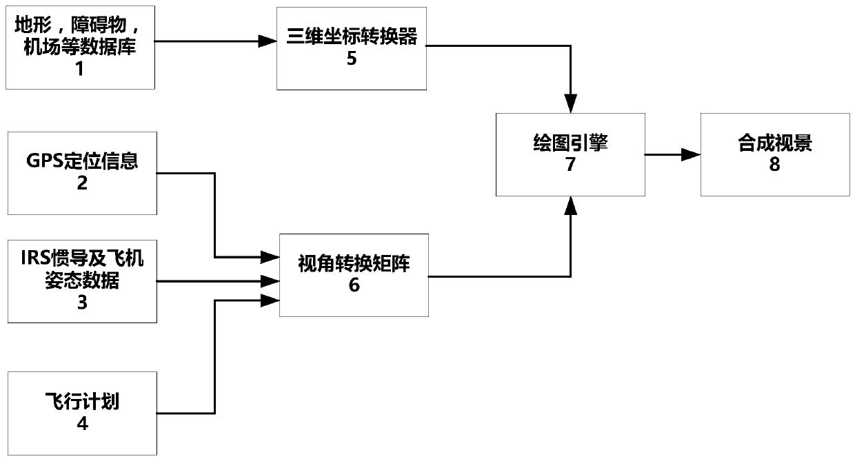
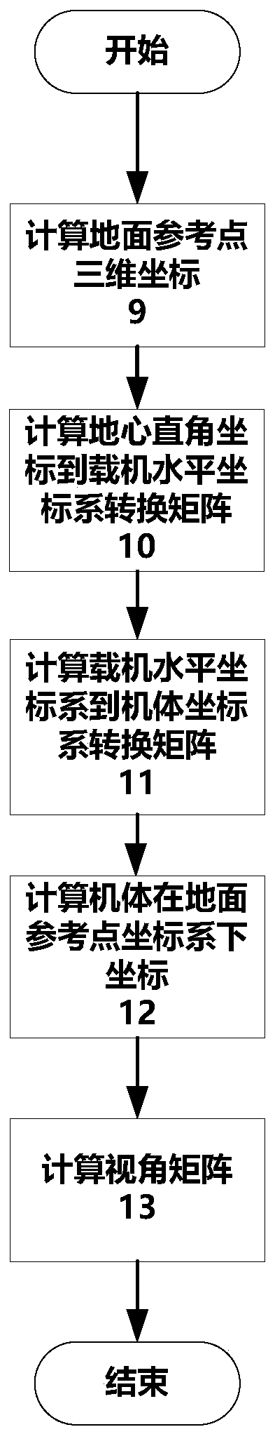
[0025] The airborne synthetic visual scene uses terrain data, aircraft position, heading and attitude information to perform three-dimensional rendering of the flight track, trend vector and surrounding environment to improve the pilot’s situational awareness and situational awareness, thereby improving flight safety and Reduce the workload of pilots. Generally, airborne embedded platforms have limited computing resources and weaker graphics processing capabilities than ordinary consumer electronics. Therefore, it is more difficult to meet the requirements of resource-constrained embedded platforms and run synthetic visual systems with high real-time requirements. By adopting this method, the calculation requirements in the rendering process of the sy...


PUM


Abstract

The invention provides a three-dimensional terrain rendering method used for airborne synthetic vision, and aims at enhancing the rendering efficiency of the synthetic vision operating on the resource-constrained embedded platform, enhancing the real-time performance of the synthetic vision system and also meeting the requirements of airworthiness regulations and advisory notices for the synthetic vision system on the aspect of accuracy and security. Usually the airborne embedded platform has limited computing resource and has weaker graphic processing capacity than that of the common consumer electronics so as to be difficult to operate the synthetic vision system of high real-time requirement on the resource-constrained embedded platform. With application of the method, the computing requirement in the synthetic vision rendering process can be reduced, the terrain rendering efficiency can be enhanced, the computing process can be optimized and the terrain rendering accuracy can also be guaranteed. The test platform verifies that the three-dimensional rendering efficiency can be effectively enhanced by the method.

Description

Technical field [0001] The invention belongs to the airborne synthetic visual scene technology, and relates to a three-dimensional terrain rendering method for the airborne synthetic visual scene. Background technique [0002] The limited vision of aircraft pilots is one of the main factors of serious flight accidents worldwide. In order to solve this problem, research institutions in various countries have invested a lot of manpower and material resources to develop new aircraft cockpit display technology. The synthetic visual system came into being under this background. Synthetic vision is a system that uses terrain data, obstacle data, and airport runway data to generate three-dimensional virtual vision, and integrates the virtual vision with flight instrument information, guidance information, and warning information. One of the key components of the new combined display system (SVS, EVS, HUD) required by civil aircraft to improve the low-visibility takeoff and landing cap...

Claims


Application Information

Patent Timeline
Patent Type & Authority Patents(China)
IPC IPC(8): G06T15/00G06T17/05
CPCG06T15/005G06T17/05
Inventor 马兵兵张锦赓黄程
Owner LUOYANG INST OF ELECTRO OPTICAL EQUIP OF AVIC
Why Eureka
Try Eureka