
Method for video layout planning based on time-space two dimensions

A space planning and video technology, applied in the field of big data, can solve problems such as lack of solutions and quantitative index systems, staying in methodology, lack of science, and data support for system solutions, so as to reduce the interference of human subjective factors and ensure Applicability and long-term effects

Inactive Publication Date: 2017-05-17
SOUTH CHINA NORMAL UNIVERSITY
View PDF1 Cites 6 Cited by
  • Summary
  • Abstract
  • Description
  • Claims
  • Application Information

AI Technical Summary

Problems solved by technology

[0003] Although the ideas of the two methods have played a certain role in promoting social public video and bayonet planning, due to the lack of scientific and systematic solutions and necessary data support, the above planning concepts still remain at the methodological level and lack specific solution and quantitative index system
[0004] Moreover, the site selection of the video (bayonet) in the two methods mainly relies on local personnel or experienced staff who are familiar with the terrain to arrange the sites, and it is impossible to achieve a working method that is separated from manual operations.
At the same time, social security video (checkpoint) mainly serves the public security industry, and the specific planning must be closely related to the business of "fighting, prevention, management, and control" of public security, so there are still certain difficulties in actual promotion and application

Method used


Image

  • Method for video layout planning based on time-space two dimensions
  • Method for video layout planning based on time-space two dimensions
  • Method for video layout planning based on time-space two dimensions

Examples


Embodiment Construction

[0077] The present invention will be described in further detail below in conjunction with the examples and the accompanying drawings, but the embodiments of the present invention are not limited thereto.

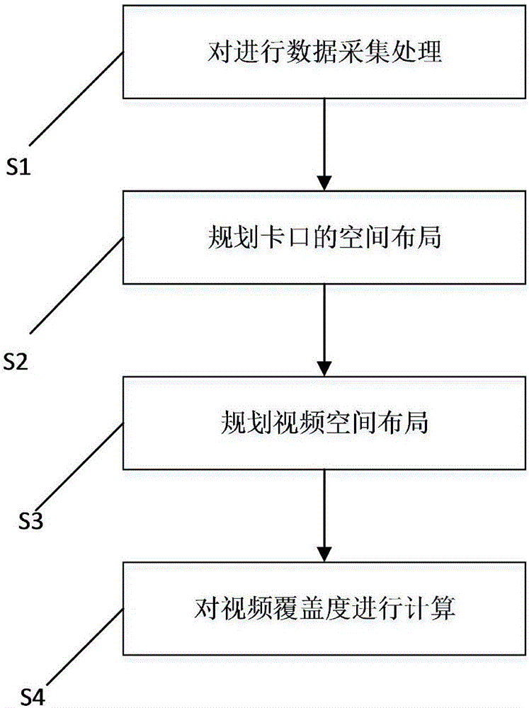
[0078] see figure 1 , which is a flow chart of the steps of the space-time two-dimensional video layout planning method of the present invention.

[0079] The present invention provides a video layout planning method based on two-dimensional time and space, comprising the following steps:

[0080] S1: Collect and process the data.

[0081] Further, the data collected in the step S1 includes: basic geographic information, geographic information on traffic themes, geographic information on public resources, and geographic information on police services.

[0082] Specifically, the basic geographic information includes: basic maps, landforms, buildings and structures, water systems, land uses, and the like.

[0083] The traffic thematic geographic information includes: traff...


PUM


Abstract

The invention provides a method for video layout planning based on time-space two dimensions. The method comprises the steps that (S1) data is collected; (S2) space layout of ports is planned; and (S3) video space layout is planned. In comparison with the prior art, the method provided by the invention is characterized in that a visual pyramid graded address selection model is established through design and quantification of planning indexes; and the model is used to complete rational planning of videos (ports) in a whole province. Hence, a scientific and accurate layout point basis can be provided for an urban united prevention and control system more effectively.

Description

technical field [0001] The invention relates to the field of big data, in particular to a space-time two-dimensional video layout planning method. Background technique [0002] In the past, social video (checkpoint) planning was mainly based on empirical knowledge, and extensive thinking was used to determine the spatial point of surveillance video. In recent years, with the deepening of the construction of the crime prevention and control system, the public security department urgently needs a scientific, accurate and reasonable public video (checkpoint) planning method. At present, there are two social surveillance video (bayonet) planning ideas recognized by the public security department in our country, namely "circle block grid line points" and "five network projects". Among them, the concept of "circle block grid line point" considers the spatial relationship between administrative divisions, roads, information points and cities, and "encloses", "cuts", "grids", "conn...

Claims


Application Information

Patent Timeline
Patent Type & Authority Applications(China)
IPC IPC(8): G06F17/50H04N7/18
CPCG06F30/18G06F30/20H04N7/181
Inventor 李卫红
Owner SOUTH CHINA NORMAL UNIVERSITY
Learn More