A flight simulator situation rendering method

A flight simulator and situational technology, applied in the field of simulation, can solve the problems of no weapon deterrent range, launch beam, line-of-sight rendering, no support for real-time rendering of the sky, and database not suitable for command and control, etc., to achieve realistic simulation effects

Active Publication Date: 2021-01-12
北京蓝天航空科技股份有限公司
View PDF3 Cites 0 Cited by
  • Summary
  • Abstract
  • Description
  • Claims
  • Application Information

AI Technical Summary

Problems solved by technology

[0003] 1. The terrain module of some software only uses the database from the perspective of the pilot, and uses an algorithm to directly render the static database. The database rendered by this algorithm is not suitable for command and control;
[0004] 2. The sky module of some software uses skybox technology for simulation, but only applies the algorithm for simulating several typical time points, and does not support real-time rendering of the sky;
[0005] 3. The special effects module of some software only simulates the special effects. This method does not render the radar scanning direction, range, weapon deterrence range, launch beam, line of sight, etc.

Method used


Image

  • A flight simulator situation rendering method
  • A flight simulator situation rendering method
  • A flight simulator situation rendering method

Examples


Embodiment Construction

[0033] The present invention will be further described in detail below in conjunction with the embodiments and the accompanying drawings, but the embodiments of the present invention are not limited thereto.

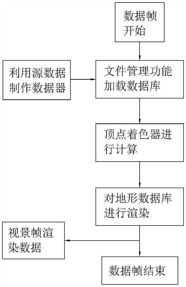
[0034] The design method of the terrain module is as follows: firstly classify the remote sensing image data and digital elevation data, then use VPB to make the source data into a database, and then use the file management function to load the database, and then obtain the longitude and latitude of each vertex in the vertex shader , and then combine the height information of each vertex for coloring, and finally generate a terrain database suitable for command and control special effects through OSG rendering.

[0035] figure 1 It shows the design flow chart of the terrain module. The graphics and image rendering in the field of flight simulation is iterated according to the frame rate, usually with 60Hz as the frame period for calculation, so the realization starts fro...


PUM


Abstract

The invention discloses a flight simulator situation rendering method, is realized on the basis of OSG and at least comprises rendering for a landform module. The method comprises steps that A1, two types of original data including the remote sensing image data and the digital elevation model data are resolved, and a database is established; A2, database loading is realized at a pre-determined frame period, and a vertex coloring device is further utilized to color each vertex; and A3, after coloring, a special-efficacy landform database suitable for command control is generated through OSG rendering. The method has an advantage of abundant functions.

Description

technical field [0001] The invention relates to the technical field of simulation, more specifically, it relates to a flight simulator situation rendering method. Background technique [0002] With the rapid development of computer graphics and virtual technology, the fidelity of graphics and images is getting higher and higher. At present, in the field of flight simulation, the related technologies of situation simulation have also been developed accordingly. However, the situation simulation software on the market simulates some basic There is still a large difference between the functions of the user and the real needs and concerns of the users. The main situations are as follows: [0003] 1. The terrain module of some software only uses the database from the perspective of the pilot, and uses an algorithm to directly render the static database. The database rendered by this algorithm is not suitable for command and control; [0004] 2. The sky module of some software us...

Claims


Application Information

Patent Timeline
Patent Type & Authority Patents(China)
IPC IPC(8): G06T15/55G06F30/20
CPCG06T15/55G06F30/20
Inventor 詹淇
Owner 北京蓝天航空科技股份有限公司
Why Eureka
Try Eureka