Satellite remote sensing image atmospheric correction spectral analysis method

A technology of atmospheric correction and satellite remote sensing, which is applied in the field of satellite remote sensing, and can solve problems such as the need to improve the accuracy of atmospheric correction, the high cost of correction, and the increase in the cost of atmospheric correction

Inactive Publication Date: 2017-01-18
NORTHEAST NORMAL UNIVERSITY
View PDF4 Cites 4 Cited by
  • Summary
  • Abstract
  • Description
  • Claims
  • Application Information

AI Technical Summary

Problems solved by technology

[0010] ① Atmospheric correction accuracy needs to be improved
[0011] ②Atmospheric correction of mountain images relies on DTM, which increases the cost of atmospheric correction
[0012] ③The cost of high-precision atmospheric correction is high (synchronous measurement of atmospheric parameters, or simultaneous measurement of surface object reflectivity), most applications are unacceptable, and atmospheric correction has to be given up

Method used


Image

  • Satellite remote sensing image atmospheric correction spectral analysis method
  • Satellite remote sensing image atmospheric correction spectral analysis method
  • Satellite remote sensing image atmospheric correction spectral analysis method

Examples


Embodiment Construction

[0070] GPFX atmospheric correction is completed in two steps: (1) write the atmospheric correction program; (2) run the atmospheric correction program for atmospheric correction.

[0071] (1) Write the atmospheric correction program:

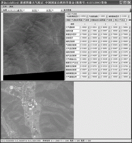
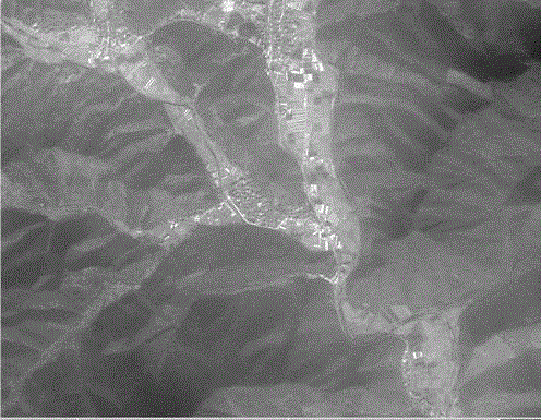
[0072] The GPFX atmospheric correction program adopts Visual Studio C#2008, and according to the technical plan ① the satellite remote sensing image is calibrated into a reflectivity image; ② the reflectivity image is separated into a ground object image and an atmospheric image; It is QB9963, with a total of 6673 lines of source programs, in which formulas (1)-(18) are rewritten into C# language programs to complete the above three operations, and supplementary image reading and writing, image browsing, parameter input and other auxiliary codes constitute QB9963. All the images of atmospheric correction results in this paper are completed by QB9963, and the "AA" version of QuickBird satellite remote sensing images is used to test the effect of ...


PUM


Abstract

The invention belongs to the technical field of satellite remote sensing, and particularly relates to a satellite remote sensing image atmospheric correction spectral analysis method. Atmospheric correction is performed according to spectral information of the image completely with no requirement for equivalent precision of the image topographic relief area and the flat area after DTM correction or synchronous atmospheric measurement data or ground object reflectivity measurement data, and the correction precision is obviously better than that of the image corrected by the present popular atmospheric correction software. The output atmospheric image and the ground object image are reflectivity images and can be synthesized into true color images and used for quantitative analysis. Landform information and BRDF information of the original image are completely reserved. Partitioned correction is performed on a huge image and the images are spliced into a complete image without lapping defect, and general atmospheric correction software can be developed. The satellite remote sensing image atmospheric correction spectral analysis method is the scientific achievement of the China's national natural science fund ("remote sensing image atmospheric correction spectral vector analysis model", the grant number: 41371394) project.

Description

technical field [0001] The invention belongs to the technical field of satellite remote sensing, and in particular relates to a spectral analysis method for atmospheric correction of satellite remote sensing images. Background technique [0002] Typically, satellite remote sensing images come from ground object reflection radiation, accounting for 50% in the 450nm band and 80% in the 850nm band, which are superimposed with the atmospheric image through atmospheric scattering and absorption, resulting in blurred ground objects and spectral Distortion, build a model to correct the influence of the atmosphere on the image to obtain a clear image of the surface object, and obtain accurate data of the reflectance of the surface object. Scholars at home and abroad have conducted research for more than 40 years and have achieved gratifying results. The results have been included in the remote sensing theory system and written in monographs , the excellent results were developed int...

Claims


Application Information

Patent Timeline
IPC IPC(8): G06T5/00
CPCG06T2207/30181G06T2207/10024G06T2207/10032G06T5/00
Inventor 陈春张树清卢珊韩阳赵建军瞿瑛
Owner NORTHEAST NORMAL UNIVERSITY
Why Eureka
Try Eureka