
Accounting method for setting visual corridor three dimension scale under urban planning design

A technology of urban planning and design and corridors, applied in the direction of calculation, instrumentation, electrical digital data processing, etc., can solve problems that are not practical, have to be adopted according to the actual situation, and cannot comprehensively solve practical problems

Active Publication Date: 2016-11-30
QINGDAO TECHNOLOGICAL UNIVERSITY
View PDF2 Cites 6 Cited by
  • Summary
  • Abstract
  • Description
  • Claims
  • Application Information

AI Technical Summary

Problems solved by technology

However, in actual operation, no specific calculation basis is provided for how to control the vertical and horizontal scales inside the corridor by combining people's sight ability and the existing surrounding buildings. There are also a few domestic research papers involving visual corridors, such as China The thesis titled "Sight Analysis and Altitude Control ~ Taking the Protection of Beijing and Xi'an Historic and Cultural Cities as Examples" by Wang Shengli of the Academy of Arts discussed the problem of visual corridors in a relatively complete way, but there are still the following problems: First, human vision In the ability analysis, the analysis is only done from the angle of sight (P19), while the observer is usually in a state of looking around during the observation process
Therefore, it can only be said that the sight angle has a certain degree of influence on the corridor, and the analysis of the human eye's sight distance ability is an important factor affecting the setting of the corridor; the second is the introduction of the concept of "visual landscape control surface" in the paper (P23) , which is an ideal visual environment analysis. In actual work, there will be a problem of coordinating the relationship between the original building, the building under construction, the building to be built and the corridor target, and the height control between the viewpoint and the target is also a problem. It will show a dynamic change process with the change of the sight distance, and the analysis from the perspective of building shielding coefficient cannot fully solve the practical problems; thirdly, the design of corridors must be based on the actual situation and adopt mandatory regulations
In the paper, the "building control height table" classification method (P30) is adopted for the height control of buildings within the vertical 6° angle of view of the ancient city of Beijing, which is rigid and not practical

Method used


Image

  • Accounting method for setting visual corridor three dimension scale under urban planning design
  • Accounting method for setting visual corridor three dimension scale under urban planning design
  • Accounting method for setting visual corridor three dimension scale under urban planning design

Examples


Embodiment

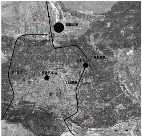
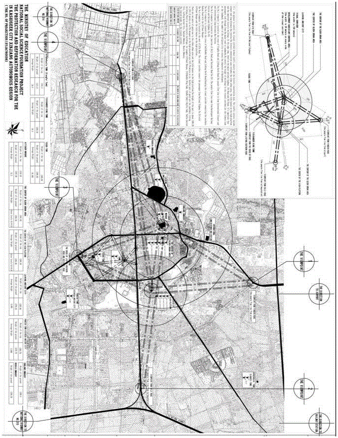
[0031] In this embodiment, taking Kashgar, Xinjiang as an example, the three-dimensional scale is set under different viewing distance conditions. The specific process is as follows:

[0032] Step 1: Kashgar has identified four urban viewpoints located on the main traffic routes and hubs:

[0033] Viewpoint 1: The intersection of Yingbin Avenue where the flow of people from Kashgar International Airport and International Long-distance Bus Station enters the urban area;

[0034] Viewpoint 2: The passenger flow of Kashgar Railway Station is from the intersection of National Highway 315 and Century Avenue;

[0035] Viewpoint 3: On the south side of Kashgar City, the South Ring Expressway and the 315 National Highway heading north to the urban area converge at the intersection of Keziduwei Road (Kanjian Road) and Jiefang South Road;

[0036] Viewpoint 4: The traffic on National Highway 314 on the east side of the urban area extends along Xiyu Avenue to the west end of the road th...


PUM


Abstract

The invention belongs to the technical field of urban design and planning, and relates to an accounting method for setting a visual corridor three dimension scale under urban planning design. The method comprises the steps that layered height limiting is conducted on a building in the direction of the horizontal axis of a corridor through specific analysis on the length and width of the visual corridor and the height of the target building; specific data accounting is conducted on the height of the building on the longitudinal axis position in the corridor according to a relation between viewpoints and the target height, a smooth visual relation between an important viewpoint of a city and a representative target landscape is guaranteed, planning design requirements of borrowed scenery and oppositive scenery within a reasonable visibility range are met, a blind one-size-fits-all city control way is effectively reduced, and setting of the visual corridor in urban planning and historical urban protection is evidence-based; specific accounting and design implementation are conducted by combining the actual urban environment situation, and scientization and systematization of urban design are guaranteed.

Description

Technical field: [0001] The invention belongs to the technical field of urban design and planning, and relates to an accounting method for setting the three-dimensional scale of the visual corridor under urban planning and design, especially the setting position of the visual corridor and the setting of its internal three-dimensional scale under different viewing distance conditions According to the calculation method, through the specific analysis of the length, width and target building height (three-dimensional scale) of the urban design and planning visual corridor, the buildings in the horizontal direction of the corridor are restricted in layers; the longitudinal axis position in the corridor ( The height of buildings with different sight distances) is calculated according to the relationship between the viewpoint and the height of the target object, so as to ensure the smooth visual connection between the important viewpoints of the city and the representative target lan...

Claims


Application Information

Patent Timeline
IPC IPC(8): G06F19/00
CPCG16Z99/00
Inventor 庞峰孟丹袁梦霄郭翔于佳璐徐彤彤
Owner QINGDAO TECHNOLOGICAL UNIVERSITY
Learn More