Spacecraft combination navigation method

A technology of integrated navigation and spacecraft, applied in the directions of integrated navigator, navigation, surveying and navigation, etc., can solve the problems of drift, inapplicability, and inability to use for a long time, and achieve the effect of simple algorithm and easy engineering implementation.

Active Publication Date: 2016-11-23
SHANGHAI AEROSPACE CONTROL TECH INST
View PDF4 Cites 9 Cited by
  • Summary
  • Abstract
  • Description
  • Claims
  • Application Information

AI Technical Summary

Problems solved by technology

[0002] Orbital parameters are required to determine the attitude of the body relative to the orbital system based on the star sensitivity, and there is drift in the added table, and the inertial navigation integration leads to navigation accumulation errors, and the orbital parameters cannot be calculated based on the position / velocity output by the inertial navigation for a long time
[0003] The ground is generally based on the WGS-84 non-inertial system for inertial navigation calculation, which is not applicable in high latitude areas; the orbit is generally based on the orbit flat root noted on the ground for orbit calculation, which cannot be used for a long time and is not suitable for orbit changes

Method used


Image

  • Spacecraft combination navigation method
  • Spacecraft combination navigation method
  • Spacecraft combination navigation method

Examples


Embodiment Construction

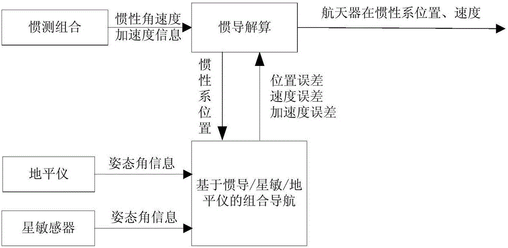
[0016] Such as figure 1 As shown, the present invention provides a kind of spacecraft integrated navigation method, realizes the star-sensitive / horizon / inertial autonomous astronomical integrated navigation based on PI filter, estimates the position / velocity error correction amount based on the star-sensitive and the horizon geocentric pointing deviation, and Determine orbit parameters based on inertial-astronomical integrated navigation, which specifically includes:

[0017] Calculate the inertial navigation position error based on the star sensitivity and the earth center pointing deviation of the horizon, and estimate the position / velocity error correction amount based on the PI filter;

[0018] Inertial navigation calculation based on J2000 inertial system, and inertial-astronomical integrated navigation based on position / speed error correction;

[0019] The orbit parameters are calculated based on the position / velocity output by the inertial-astronomical integrated navig...


PUM


Abstract

The invention relates to a spacecraft combination navigation method. The problem that as drifting exists on the earth surface, the orbital parameter cannot be calculated based on the positions/speeds output based on inertial navigation for a long time is solved through satellite sensor/horizon sensor/inertia automatic astronomy combination navigation based on PI filtering. The positions and the speeds output by inertial navigation are corrected based on the earth core pointing error determined by a satellite sensor and a horizon sensor, the inertial navigation accumulative error can be restrained through the inertia/astronomy combination navigation. According to the spacecraft combination navigation method, under the abnormal situations that a satellite GNSS compatible machine becomes abnormal and ground orbital parameters are not transmitted in real time, corresponding orbital parameters are calculated through the positions/speeds output by the satellite sensor and horizon sensor inertia-astronomy combination navigation, and the posture, determined based on a satellite sensor, of a body relative orbit system can be ensured. Compared with the prior art, the spacecraft combination navigation method has the advantages that the algorithm is simple and effective and engineering achievement is easy.

Description

technical field [0001] The invention relates to a spacecraft integrated navigation method, in particular to a PI filter-based star-sensing / horizon / inertial autonomous astronomical integrated navigation method. Background technique [0002] Orbital parameters are required to determine the attitude of the body relative to the orbital system based on the star sensitivity, and there is drift in the added table, and the inertial navigation integration leads to cumulative navigation errors, and the orbital parameters cannot be calculated based on the position / velocity output by the inertial navigation for a long time. [0003] The ground is generally based on the WGS-84 non-inertial system for inertial navigation calculation, which is not applicable in high latitude areas; the orbit is generally based on the orbit flat root noted on the ground for orbit calculation, which cannot be used for a long time and is not suitable for orbit changes . [0004] Correct the position and velo...

Claims


Application Information

Patent Timeline
Patent Type & Authority Applications(China)
IPC IPC(8): G01C21/24G01C21/00G01C21/16
CPCG01C21/005G01C21/165G01C21/24
Inventor 王献忠张丽敏张肖张国柱程颢汤敏兰
Owner SHANGHAI AEROSPACE CONTROL TECH INST
Why Eureka
Try Eureka